
Data Downloads
Posters of Rangewide Distribution
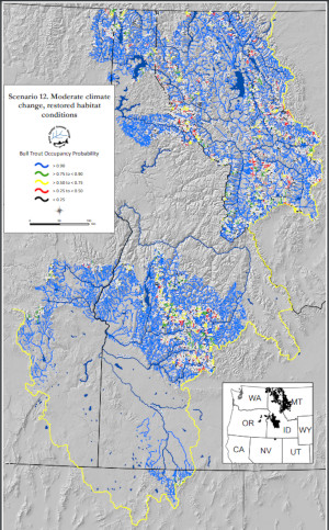
Revised Bull Trout Climate Shield ModelIsaak et al. (2022) published a revised Climate Shield model for juvenile bull trout that provides stream-specific probabilistic predictions about occurrence within 991 natal habitat patches across Montana, Idaho, and eastern Oregon. The model is more accurate than the original Climate Shield model and was used in 16 scenarios to assess the effects of habitat restoration and brook trout removals on improving population resilience under three climatic conditions (baseline, moderate change, and extreme change). That information is available from the table below as digital maps (.pdf files) and ArcGIS shapefiles. Please refer to this ReadMe document for descriptions of the scenarios and the Isaak et al. 2022 publication for additional details.
Related WebsitesNorWeST: Regional Database & Modeled Stream Temperature SSN & STARS: Tools for Spatial Statistical Modeling on Stream Networks Stream Temperature Modeling and Monitoring U.S. Stream Flow Metric Dataset National Genomics Center for Wildlife and Fish Conservation Sculpins of the West - A molecular taxonomy of Cottus in western North America The Range-Wide Bull Trout eDNA Project
Find W&W and follow us on your favorite social media site:
| RMRS Home | W&W Home | Disclaimers | Freedom of Information Act (FOIA) | Privacy Notice | Quality of Information | Print This Page | https://www.fs.usda.gov/rm/boise/AWAE/projects/ClimateShield/maps.html | ||||||||||||


