

Pinaleno Mountains

 The Pinaleno Mountains have a paved highway to the top. It has been designated the Swift Trail Scenic Byway. Photo by Charlie McDonald.
 Desertscrub and grasslands surround the base of this mountain range. Photo by Charlie McDonald.
 Deep canyons often have running water and support lush understory vegetation. Golden columbine (Aquilegia chrysantha) in the foreground is common in this type of habitat throughout the Sky Islands. Photo by Charlie McDonald.
 The Columbine Visitor’s Center sits in mixed conifer forest at over 9,000 feet in elevation, very different from the desert only a few miles below. Photo by Charlie McDonald.
 This grassy bald at the crest of the mountain range shows the effects of repeated fires. Photo by Charlie McDonald.
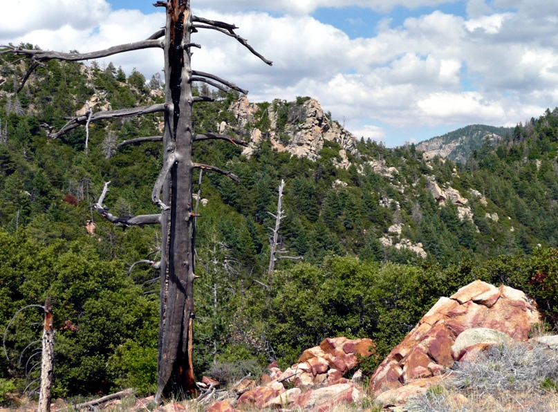 This is typical scenery along the crest of the Pinaleno Mountains. Photo by Charlie McDonald.
High Point: Mount Graham, 10,724 feet
Elevation Change from Base: 7,524 feet
Vegetation at Highest Elevations: Engelmann Spruce–Alpine Fir Forests
The Pinaleno Mountains are the highest of Arizona’s Sky Island mountain ranges and are the only range with peaks higher than 10,000 feet in elevation. While other Sky Island mountain ranges may have a few sharp peaks that project well above the general elevation of the range, the summit of the Pinaleno Mountains is relatively level with extensive areas above 9,000 feet in elevation. The elevations above 10,000 feet support the southernmost Engelmann spruce-corkbark fir old growth forest in the United States. Extensive Douglas-fir–mixed conifer forests are found throughout the mountaintop above about 8,500 feet and lower in canyons and on north-facing slopes. Subalpine meadows are found in many of the areas identified as “flats” on topographic maps; Hospital Flat and Chesley Flat are two examples.
Special Places:
- Swift Trail (Arizona Highway 366): With over 7,000 feet of vertical relief, a drive on this highway is the ecological equivalent of driving from Mexico to Canada, all in one leisurely afternoon. The road is 35 miles long, with 22 miles paved and 13 miles graded dirt. There are six campgrounds and two picnic areas along the way, most of them at the higher elevations. There are many hiking trails that vary from short loops through mountain meadows to rigorous climbs of more than 5,000 feet from the desert valley to the alpine forests.
- Mount Graham International Observatory: The sky conditions in southeastern Arizona are among the best in the world for astronomical observations. Congress authorized construction of the first telescope on Mount Graham in 1989. The observatory now has three telescopes, with the Large Binocular Telescope being one of the world’s largest and most powerful. Tours of the observatory are available, but must be booked in advance through the Discovery Park Campus of Eastern Arizona College. Establishment of the observatory on Mount Graham created two points of controversy. First, some Native Americans consider the site to be sacred and argued that an observatory would deface the sacred mountain. Second, some environmentalists worried that construction would harm the endangered Mount Graham red squirrel that occupies the very limited spruce-fir forest on Mount Graham. Actions to minimize impacts to the squirrel have included: careful site selection for the telescopes, minimizing the telescopes’ footprint, establishing a 1,750 acre red squirrel refugium, reforestation of some previously disturbed habitat, and a continuing program of study and monitoring.
Special Plants:
- Erigeron heliographis
- Hieracium rusbyi
- Potentilla albiflora
Further Reading: