

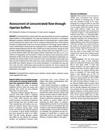
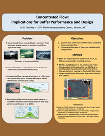
AgBufferBuilder
AgBufferBuilder is a GIS-based computer program for precision design of vegetative filter strips around agricultural fields. The tool analyses the terrain for spatial patterns of overland runoff and designs a variable-width configuration that matches those patterns to provide a constant, user-selected, level of performance along the field margin. The tool also can assess the performance level of existing or hypothetical configurations.
Why Use AgBufferBuilder?
- To improve filter strip performance by enlarging the strip where overland flow concentrates.
- To reduce costs by downsizing filter strip where little runoff flow occurs.
- To assess and compare the performance of alternative designs.
- AgBufferBuilder designed configurations are, on average, twice as effective as fixed width configurations covering the same number of acres (see AgBufferBuilder: A geographic information system (GIS) tool for precision design and performance assessment of filter strips).
AgBufferBuilder 2.0 works with ArcGIS 10.0, 10.1, 10.3, and 10.4.
Documentation
- How to use it: Users Guide for AgBufferBuilder Version 2.0 (PDF, 1.7 MB)
- How it works: AgBufferBuilder: A geographic information system (GIS) tool for precision design and performance assessment of filter strips (PDF)
Supporting Information

Webinar
WebinarLink opens a new window. providing an overview of the AgBufferBuilder tool presented to the Ohio Watershed Network on September 2, 2015.


Practice data
A complete set of prepared input files and results of both a design procedure and an assessment procedure (.zip, 3.3 MB).
Development History
AgBufferBuilder utilizes relationships between buffer-area-ratio and performance that were developed using the process-based Vegetative Filter Strip Modeling System. Those relationships were, then, adapted to run with ArcGIS (ESRI, Redlands, CA). Key stages in the development of AgBufferBuilder are described in the following publications.
Contact
Todd Kellerman, tkellerman@fs.fed.us
Funded by


Funding to support development of AgBufferBuilder was provided by the U.S. Department of Agriculture, Forest Service, National Agroforestry Center, Lincoln, Nebraska and Southern Research Station, Asheville, North Carolina to the University of Kentucky (grant no. 10-JV- 11330152-119) and from Kentucky state water quality grants (SB-271) administered by the University of Kentucky, College of Agriculture, Food and Environment, Lexington, Kentucky.
Disclaimer
AgBufferBuilder and associated documentation is supplied as-is with no warranty, explicit or implied. The quality of results is highly dependent on the user’s skill and ability to select input data and parameters that accurately represent the field site, to run GIS software, and to properly interpret the results.