

Fern Viewing Areas
Fern Viewing Areas on National Forests
Art’s Dream Fern Area
Art’s Dream Fern Area is located in the Cle Elum Ranger District, Okanogan and Wenatchee National Forest, on the east side of Cle Elum Lake, near the base of the east slope of the Washington Cascade Range. It is the richest fern site known on the Cle Elum Ranger District, as well as in eastern Washington, in both diversity of fern species and population size. The majority of the ferns are associated with a massive rock outcrop and associated bare ridges that overlook the lake.
The rock outcrop is on the lower slopes of Sasse Ridge and forms part of the east side of the Cle Elum Lake basin. This outcrop provides ideal habitat for six species of small rock ferns and a rich assemblage of dry site flowering plants. This rock outcrop is most prominent on the side overlooking Cle Elum Lake. The outcrop then continues as a series of bare ridges interspersed with forested draws and slopes as Sasse Ridge climbs upward away from the lake to an elevation of 5,400 feet. The six species of rock ferns found on the site grow only on rock outcrops, talus slopes, rock ledges, or cliff faces. These ferns are Indian’s dream fern (Aspidotis densa), lace fern (Cheilanthes gracillima), American parsley fern (Cryptogramma acrostichoides), mountain cliff fern (Woodsia scopulina), fragile fern (Cystoperis fragilis) and western polypody (Polypodium hesperium).
Four of these ferns (Indian’s dream fern, lace fern, American parsley fern and mountain cliff fern) are associated with dry conditions on open rock and shallow soils.
There are moist cliff faces along parts of Dry Creek, where the creek is deeply incised. In these areas, spraying water from the creek increases humidity and along with the presence of small seeps in the rock walls provide habitat for the fifth rock fern, western polypody. This fern also grows in wet cracks along rocky ridges. The sixth rock fern, fragile fern, can tolerate dry, rocky conditions, but often grows on moist rock.
In addition, western sword fern, Polystichum munitum, grows in the area’s moderately moist forests with deeper soils.
Art’s Dream Fern Area is located east of Cle Elum Lake, just east of and bordering Cle Elum River Road, SR903. Access is via SR903, north from Ronald. There is a designated lake view pullout for parking on the west side of the main road 3.8 miles north of Wish Poosh Campground, or on road 903-120, north of the pullout. On foot from the pullout, access is to the southernmost rock outcrop as it rises directly from the north side of the spur road; from the 903-120 road, access is east up Dry Creek drainage. The area is approximately 280 acres (113 ha.) in size; the elevation ranges from 2,400 feet to 5,120 feet (1,646 to 1,561 meters) above sea level.
Dr. Arthur Kruckeberg, University of Washington, first brought this site to the attention of the Cle Elum Ranger District in a July 2000 letter, wherein he stated “there is no other locality in eastern Washington as rich in fern diversity, as is this massive, nearly treeless outcrop”. When Dr. Kruckeberg originally suggested that the Forest Service protect the rock outcrop as an important fern site, he proposed naming the area “Indian’s Dream”, the common name of a small rock fern (Aspidotis densa). In appreciation for his efforts in bringing this area to the attention of the Forest Service, the proposed Botanical Special Interest Area will be named “Art’s Dream”, after Dr. Kruckeberg.
Devil’s Head National Recreation Trail
Devil’s Head National Recreation Trail is on the Pike National Forest in central Colorado. Devil’s Head is about 55 miles southwest of Denver. Take US Highway 85 (called Santa Fe Drive in Denver) from Denver south to Sedalia. At Sedalia, turn right (west) on State Highway 67 and go west to Rampart Range Road, turn left (south) onto Rampart Range Road and then continue 10 miles to the Devil’s Head National Recreation Trailhead. Visitors from the south may reach Devil’s Head by following I-25 to Castle Rock and following U.S. Highway 85 to Sedalia. Devil’s Head is a prominent granite outcrop with a 360° panoramic view; on clear days mountains over 100 miles away are visible from the top of the trail!
 A view of the end of the Devil's Head Trailhead. Photo took from the lookout. US Forest Service.
This trail of moderate difficulty ends at the top of Devil’s Head. The hike is 1.4 miles long one-way and gains 940 feet in elevation, but the hike is not strenuous. There are several rest stops with benches and tables along the trail.
The Rampart Range is a ridge of Pike’s Peak granite. The area is dominated by coniferous forest with some grassy meadows. There is a parking area and a campground at the base of Devil’s Head. Near the base of the trail, male fern (Dryopteris filix-mas) grows in cracks in the granite. Near the top of Devil’s Head a side trail leads to the Zinn Memorial Overlook where you can see more male ferns and Rocky Mountain polypody (Polypodium saximontanum). Forked spleenwort (Asplenium septentrionale) and Oregon cliff fern (Woodsia oregana subsp. cathcartiana) also grow here. On the top of Devil’s Head is one of the few remaining functional wildfire lookout towers, which is staffed and open to the public from mid-May through mid-September. Several creeks flow down the east side of the Rampart Range. Along them you can see lady ferns, Athyrium filix-femina subsp. cyclosorum. An interesting thing about these lady ferns is that they resemble the eastern subspecies A. f. subsp. angustum. Scouring rushes, Equisetum hyemale, also grow along these creeks.
East Glacier Trail
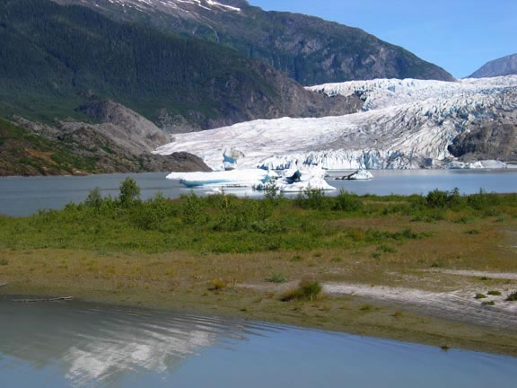 Mendenhall Glacier flows into Mendenhall Lake. Pioneering shrubs and herbs on the lake margin. Photo by Mary Stensvold.
The East Glacier Trail is located at Mendenhall Glacier, Juneau Ranger District, Tongass National Forest, Juneau, Alaska. Although the entire loop trail is impressive in the number of ferns that line the trail, the first 1.5 miles of the loop’s west side supports a wide array of ferns (see the trail on this map). The following is a list of ferns that can be found along the trail:
- Western maidenhair fern, Adiantum aleuticum
- Northwestern lady fern, Athyrium filix-femina subsp. cyclosorum,
- Deer fern, Blechnum spicant
- American parsley fern, Cryptogramma acrostichoides
- Alaska parsley fern, Cryptogramma sitchensis
- Fragile fern, Cystopteris fragilis
- Northern wood fern, Dryopteris expansa
- Western oak fern, Gymnocarpium disjunctum
- Northern beech fern, Phegopteris connectilis
- Licorice fern, Polypodium glycyrrhiza
- Anderson’s sword fern, Polystichum andersonii
- Braun’s holly fern, Polystichum braunii
- Holly fern, Polystichum lonchitis
- Alaska sword fern, Polystichum setigerum
- Mountain wood fern, Thelypteris quelpaertensis,
- Rusty cliff fern, Woodsia ilvensis
Meyers Creek
Meyers Creek is located on the Ouachita National Forest, Garland County, Arkansas. From Hot Springs, Arkansas, go west on Highway 270 to the town of Royal, continue for approximately two more miles. Turn south on County Road 112 (Ragweed Valley Road) for approximately 6 miles. Turn south on County Road 103 (Meyers Creek Road) and go approximately 1.5 miles. The seep is on the west side of the road.
This area is a network of springs and seeps feeding Meyers Creek. The area can be described as a wood seep dominated by oak and hickories. Common woody species include umbrella magnolia, spicebush and red maple. There is diverse herbaceous vegetation throughout the area, and the area is known for its wide variety of ferns. Listed below are some of the ferns and other interesting plants scattered throughout the area.
- Northern maidenhair fern, Adiantum pedatum
- Ebony spleenwort, Asplenium platyneuron
- Lady fern, Athyrium filix-femina var. asplenioides
- Southern grapefern, Botrychium biternatum
- Rattlesnake fern, Botrychium virginianum
- Dryopteris australis
- Log fern, Dryopteris celsa
- Sensitive fern, Onoclea sensibilis
- Southern adder’s tongue fern, Ophioglossum vulgatum
- Cinnamon fern, Osmunda cinnamomea
- Royal fern, Osmunda regalisvar. spectabilis
- Broad beech fern, Phegopteris hexagonoptera
- Resurrection fern, Pleopeltis polypodioidesvar. michauxiana
- Christmas fern, Polystichum acrostichoides
- Bracken fern, Pteridium aquilinum var. pseudocaudatum
- Southern shield fern, Thelypteris kunthii
- Marsh fern, Thelypteris palustrisvar. pubescens
- New York fern, Thelypteris noveboracensis
- Blunt-lobed cliff fern, Woodsia obtusa subsp. obtusa
- Netted chain-fern, Woodwardia aerolata
Old Sauk River Trail
Old Sauk River Trail is located in the Cascade Mountains about four miles south of Darrington Ranger Station, Mt. Baker-Snoqualmie National Forest, Washington. This is an easy trail over gentle terrain along the Sauk Wild and Scenic River. You can see beautiful old forests with lush growth of mosses and ferns including:
- Northern maidenhair fern, Adiantum pedatum
- Northwestern lady fern, Athyrium filix-femina subsp. cyclosorum,
- Deer fern, Blechnum spicant
- Northern wood fern, Dryopteris expansa
- Common oak fern, Gymnocarpium dryopteris
- Licorice fern, Polypodium glycyrrhiza
- Common sword fern, Polystichium munitum
- Bracken fern, Pteridium aquilinium.
See the complete list of plants that can be found along this trail.
Perry Creek Trail
Perry Creek Trail is located in the Cascade Mountains on the Darrington Ranger District, Mt. Baker-Snoqualmie National Forest, Washington. According to the Hardy Fern Foundation, the Perry Creek-Mount Forgotten Trail (No. 711) boasts approximately 35 species of ferns and lycophytes. The trail is located roughly 75 miles east of Seattle and is the best place to view ferns in Washington State! The hike to the falls is 2 miles one way, with an elevation gain of about 1,000 feet. The first part of August is an ideal time to take this fantastic hike. Be on the lookout for:
- Maidenhair spleenwort, Asplenium trichomanes
- Green spleenwort, Asplenium viride
- Anderson’s sword fern, Polystichum andersonii
- Shasta fern, Polystichum lemmonii
- Mountain cliff fern, Woodsia scopulina
- Irregular polypody, Polypodium amorphum, and
- Many kinds of moonwort ferns, Botrychium.
Silver Meadow
Silver Meadow is in north central Utah on the Uinta National Forest. This meadow is located on the Heber Ranger District about 33 miles from Heber. The wet meadow supports a large population of dainty moonwort (Botrychium crenulatum), a tiny fern that grows only one leaf each year. The leaf is divided into a small lobed blade and a strange-looking stalk with clusters of little tiny spore-bearing capsule. Especially in the West, most moonworts are uncommon and hard to find even in known populations. The moonwort ferns are best seen on the east side of the meadow in the wet sites with shorter vegetation, mixed in with patches of pink elephant head flowers. Be sure and explore the drier uplands surrounding the meadow for displays of other wildflowers.
Vallecito Creek
Vallecito Creek is located in southwestern Colorado on the San Juan National Forest. This is one of the best places in Colorado to see a good assortment of ferns. To reach the site from Durango, follow State Highway160 East to Bayfield. The site is 22 miles north of Bayfield via Vallecito Road (County Road 501), the road passes the western side of Vallecito Reservoir. At the north end of the reservoir, pass through the Vallecito Lake community and head east around the upper end of the reservoir, then turn north onto County Road 500. The Vallecito Campground (parking for the trail) is approximately 3 miles up the road. The trail along Vallecito Creek begins at the Vallecito Campground and follows the creek into the Weminuche Wilderness.
This is an easy to moderate trail. The trail is mostly gently sloping with some moderate uphill sections, and the trail can be followed for several miles. The campground area is accessible to the disabled.
The Vallecito Campground is on a terrace by the creek with big ponderosa pines and a few cork bark firs. At the west side of the campground at the base of a limestone ridge, you can find Oregon cliff fern (Woodsia oregana subsp. cathcartiana) and Plummer’s cliff fern (Woodsia plummerae). Along with the Woodsia there are members of the fragile fern (Cystopteris fragilis) complex. Along the trail American parsley fern (Cryptogramma acrostichoides) and Fendler’s lip fern (Cheilanthes fendleri) grow. Scouring rush, Equisetum hyemale, grows near the edge of the campground, and the male fern (Dryopteris filix-mas) is quite common here. The type location for Rocky Mountain polypody (Polypodium saximontanum) is nearby. The maidenhair spleenwort (Asplenium trichomanes subsp. trichomanes) has been observed near the trail. A weedy fern, bracken (Pteridium aquilinum)sprouts up along the roadside south of the campground.
Fern Viewing Areas Not On National Forests
Fern Canyon Trail
Fern Canyon Trail is located in Redwood National Park, about 30 miles North of Arcata, California. This level trail of about 1 mile follows Home Creek as it courses through the forest. This modest stream has over the eons carved a deep (50 to 80 feet) canyon through the sedimentary soils. The vertical walls sprout an amazing variety of ferns and other moisture-loving plants and mosses.”
Ferns include California maidenhair, (Adiantum jordanii), deer fern (Blechnum spicant), California polypody (Polypodium californicum), licorice fern (Polypodium glycyrrhiza) and western sword fern (Polystichum munitum).
Fern Display and Study Gardens
The Hardy Fern Foundation has 15 satellite and display gardens throughout the United States. These are in essence test gardens, where a variety of ferns is evaluated yearly to obtain accurate hardiness information and garden worthiness under varying climactic conditions. The Hardy Fern Foundation supplies ferns to these gardens free of charge in exchange for these yearly evaluations.”
Fern Forest
Fern Forest is located near Ft. Lauderdale, Florida. Ten plant communities, including a tropical hardwood hammock, an open prairie, and a cypress/maple swamp, are protected in the 247 acres of wilderness that make up Fern Forest Nature Center, which also includes a remnant of the Cypress Creek floodway and other geological features. Several particularly interesting ferns are present in this conservation area, including shoestring fern (Vittaria lineata), resurrection fern Pleopeltis polypodioides var. michauxiana) and swamp fern (Blechnum serrulatum). The nature center is also a refuge for resident and migratory birds and wildlife.
A complex consisting of assembly hall, exhibit room, and amphitheater is near the entrance to the major trails. Trails consist of both boardwalk and foot trails. Special programs for school groups and other organizations are available by reservation. Various programs on specific topics and environmental events and walks are also presented throughout the year.
Fern Room, Garfield Park Conservatory
The Fern House of the Garfield Park Conservatory is located in Chicago, Illinois. “Jens Jensen, who designed the Conservatory in 1906, wanted to give visitors a glimpse of what Illinois might have looked like millions of years ago. Lush ferns, rocky outcroppings and an indoor lagoon evoke the swampy landscape of prehistoric Chicago.”