

Alaska Region Viewing Area
LOCATION and PHOTOS
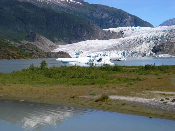 Mendenhall Glacier flows into Mendenhall Lake. Pioneering shrubs and herbs on the lake margin. Note the brownish carpet of mosses, lichens and short sedges in the spaces between the shrubs. Photo by Mary Stensvold.
 Nugget Falls, with Mendenhall Lake and shore in middle distance, with pioneering shrubs alder and willow in the foreground. A trail runs along the lakeshore between the Visitor Center and the base of Nugget Falls. Photo by Mary Stensvold.
 Beside the Moraine Ecology Trail: moss grows on a boulder dropped by the melting glacier in the recent past. The canopy of a young Sitka spruce forest is beginning to close. Photo by Mary Stensvold.
 Along the Moraine Ecology Trail a delicate array of lichens and mosses carpet the sandy soil. Young Sitka spruces are gaining a foothold. Photo by Mary Stensvold.
 Ground cone; note the numerous snapdragon-like flowers crowding each flowering spike. Photo by Mary Stensvold.
 Looking up at a rock face along the Trail of Time; “ICE LIMIT 1938” carved into the rock of a “whaleback” (rock outcrop shaped and smoothed by glacial action). Note the pioneering mosses beginning to grow on the rock. Photo by Mary Stensvold.
Mendenhall Glacier Visitor Center
Forest: Tongass National Forest
District: Juneau Ranger District
Description: Mendenhall Glacier Visitor Center Wildflower Viewing Area offers a unique opportunity to observe plant succession in action. Glacial movements have, and still are influencing where, when, and what plants may occur. Several trails radiate from the visitor center offering access to a variety of habitat types and stages of plant community development.
Wildflower Viewing: For panoramic views of the lake, glacier, peaks and sandy shoreline with its collection of early succession plants, try the Photo Point Trail (0.3 miles) and Nugget Falls Trail (0.7 miles), both begin in front of the Visitor Center. A close-up look at early succession vegetation will reveal pioneers such as tiny fungi, mosses and lichens that form a “crust” over the loose sand and facilitate the establishment of larger plants. You may notice scattered lupines (Lupinus nootkatensis), young willows (Salix spp.), Sitka spruce trees (Picea sitchensis), and Sitka alder shrubs beginning to work their way into the landscape which has been ice free for only fifty years or less.
Moraine Ecology Trail (1.5 miles) starts at the north side of the second parking lot. This trail meanders over glacial outwash plain and into young forest 25 – 100 years old. Tall black cottonwood trees (Populus balsamifera subsp. trichocarpa) join Sitka spruce and western hemlock (Tsuga heterophylla) trees along the stream where visitors may observe salmon spawning and bears fishing during the summer and fall. This area is generally flat with large open areas with a thick ground cover of an array of lichens, including Iceland, whiteworm, foam, coral, reindeer, Cladonia, kidney and pelt lichens. Mosses generally carpet the floor of young forested areas. Be sure to check shrubs and trees for other mosses and lichens. Glacial influence creates conditions similar to those in the alpine and species usually limited to alpine may be found here.
Three other trails begin behind the Visitor Center and travel upslope into forest 100 – 400 years old. As you will probably notice, the farther away and higher in elevation you are from the glacier and lake, the more diversity of broadleaf plants and larger trees you will see.
The wintergreen family is well represented in the more forested areas. Look for the tiny, one-flowered single delight (Moneses uniflora), usually on mossy logs. Most common is pink wintergreen (Pyrola asarifolia), recognized by its roundish, shiny, dark green basal leaves and small bell-shaped pink flowers nodding along the tall pink flower stalk. A close cousin, one-sided wintergreen (Orthilla secunda), gets its name from the pale-green to white bell-shaped flowers arranged along only one side of the flower stalk. It’s mostly basal leaves have toothed edges and are a clear green above and paler beneath.
Other common forest plants include dwarf dogwood (Cornus canadensis), foam flower (Tiarella trifoliata), and stair-step and lanky mosses (Hylocomium splendens and Rhytidiadelphus loreus). There are three species of twistedstalk; the tallest (up to 1 meter or more) is clasping twistedstalk (Streptopus amplexifolius) with leaf bases clasping the stem and greenish white bell-shaped flowers hanging on thin, kinked stalks; medium sized rosy twistedstalk (S. lanceolatus var. curvipes) has leaves with tiny teeth and pink flowers on curved stalks; in the most dense forest is the small twisted stalk (S. streptopoides) with plain leaves and purplish-green saucer-shaped flowers.
You may encounter small groups of purple-brown, many-flowered spikes arising from the ground under alders. This is groundcone (Boschniakia rossica), a member of the broomrape family, that makes its living by parasitizing the alder roots. In turn, its thickened rhizome is a favorite nutritious fall delicacy of bears.
Trail of Time forms a short loop (0.5miles) with an elevation gain of about 50 feet, and crosses Steep Creek twice. On this trail you will see rock outcrops with lichens, mosses, several types of saxifrages, and small ferns in the recesses. Large ferns like lady fern (Athyrium filix-femina) and shield fern (Dryopteris expansa) occur in the shaded, moist areas. In several places along this traial the date the snout of the Mendenhall Glacier left a particular area is chiseled into the rock (see the photo for the 1938 “Ice Limit”).
East Glacier Loop (3.5 miles) follows the glacial trim line with an elevation gain of about 400 feet. Forest along this trail is 100-200 years old and is beginning to develop some “old growth” characteristics, such as gaps with blueberry (Vaccinium ovalifolium) and salmonberry (Rubus spectabilis) bushes, and trees of various ages. Wet seepy conditions encourage devil’s club (Oplopanax horridus) and skunk cabbage (Lysichiton americanum) to form thickets and lush patches as inclusions in the forest matrix.
Nugget Creek Trail (3 miles + 3.5 mile access trail) follows Nugget Creek above the falls with a 500 foot elevation gain. You may reach this trail from the east portion of East Glacier Loop along Nugget Creek. Besides passing through streamside habitats with violets, buttercups, Sitka burnet (Sanguisorba canadensis), various willows, currants and gooseberries, the trail leads to a copse of yellow cedar trees (Chamaecyparis nootkatensis) which are rare in the northern part of the Tongass National Forest.
Safety First: Many black bears reside in the Mendenhall Glacier Visitor Center area and rely on the salmon return to Steep Creek and berries ripening in late summer and fall to prepare them for winter hibernation. When in bear country, make lots of noise to make your presence known especially if you are by yourself or in a small group. Bear spray and insect repellent are recommended items to carry. Be prepared for inclement weather by wearing non-cotton clothing and have rain gear handy.
Directions: Coming from downtown Juneau, you reach this area by travelling about 13 miles north on Egan Drive to the intersection of Mendenhall Loop Road. There turn right and continue straight out until the road ends at the Visitor Center. Parking is available in 2 formal parking lots and along the roadside. Watch for tourists and bears crossing the road, as well as buses loading and unloading passengers.
Map: Get a map of the Mendenhall Glacier trail system…
Ownership and Management: USDA Forest Service, Tongass National Forest, Juneau Ranger District (907) 586-8800.
Closest Town: Juneau, Alaska.