

Intermountain Region Viewing Area
Green River Lakes and Squaretop Mountain
By Charmaine Delmatier
Forest: Bridger-Teton National Forest
District: Pinedale Ranger District
Description: The Green River Lakes are nestled behind a natural terminal-moraine dam scoured out by glacial action and surrounded by the stark, cold, steep topography of the Wind River Range. Mostly composed of granite uplifts from deep within the earth over 1 billion years ago, these granite monoliths were uplifted and carved by glaciers 500,000 years ago to form circular valley cirques. The Wind River Range is not only one of the oldest mountain ranges in North America, but has the most extensive glacial network in the lower 48 states. Elevations range from 8,000 feet at Green River Lakes to 13,804 feet at Gannett Peak, the tallest mountain in the middle Rocky Mountains.
The Green River Lakes are considered the headwaters of the Green River; the chief tributary to the Colorado River. The Green River runs 730 miles through Wyoming, Utah, Colorado, and eventually terminates in northern Mexico.
The Green River Lakes are also the starting point for many backpacking trails including the northern entrance to the frequently used Highline Trail, which extends along most of the Wind River Range and follows the spine of the Continental Divide south to Big Sandy Opening.
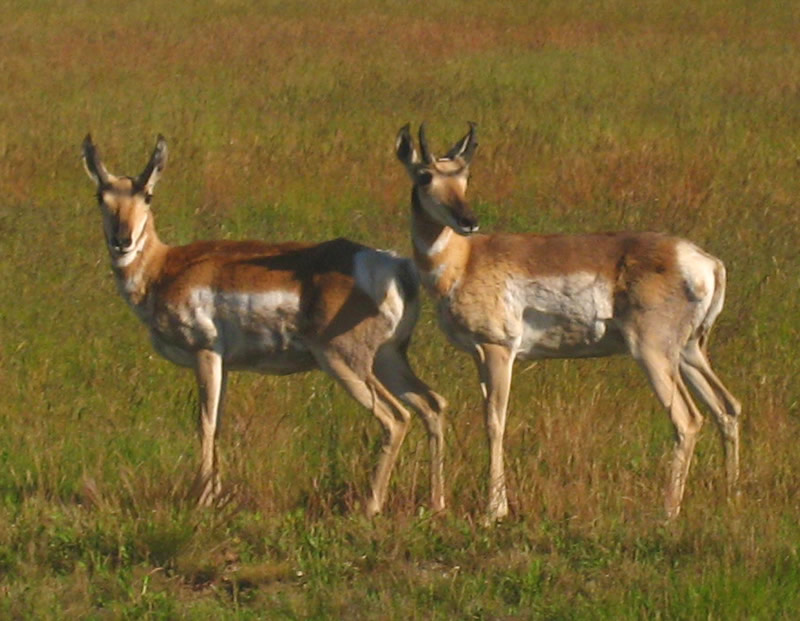 Pronghorn antelope. Photo by Drew Maraglia.
 Golden-mantled squirrel. Photo by Charmaine Delmatier.
Visitors have a view of the much-photographed large-granite monolith, Squaretop Mountain (11,695 feet, per Wind River Topographic Map, Earthwalk Press, 1998) from the Green River Lakes. The mountain looms over pristine blue-green lakes. You can expect to view glimpses of large game animals such as moose, elk, deer, and pronghorn. Other remarkable and more common animals observed in the area include several hawks, both bald and brown eagles, fox, coyote, wolverines, yellow-bellied marmots (rock-chucks), and the golden-mantled squirrel. Occasionally a black bear or grizzly bear are spotted. If you are lucky, you will be able to see or hear, set against the high alpine glaciers and rock talus, the rare white-tailed ptarmigan or the more common "king of the mountain", the pika.
Social History: The Wind River Range and the Upper Green River Valley were home to both Shoshone and Arapaho Native Americans, and provided sustenance and marketable goods for their daily livelihood as well as to early trappers and settlers. The road to Green River Lakes, which roughly parallels the river, passes the remains of the earliest dude ranch in Sublette County, the first in a long line of successful ranching businesses. For several weeks each June, the Green River Drift, one of the longest-running cattle drives in the nation takes place as wranglers push livestock from adjacent valleys to higher grounds with rich mountain pastures, a distance of about 70 miles.
It is also a naturalist and angler’s paradise being home to the Mackinaw (lake trout), golden, brook, rainbow, brown, cutthroat, and grayling trout. Motorized boats are allowed on the lower Lake; however, the earthen boat ramp is suitable only for smaller vessels. The upper lake within the Wilderness area (Upper Green River Lake), therefore no motorized boats of any kind are allowed. Jet skis and other personal watercraft are not allowed.
Safety First: It can snow any day of the year in the Wind River Range! Visitors should come prepared for cold weather. Afternoon thunderstorms and rain showers are common in the summer and can build quickly. While summer days may be warm, nights are generally cool to cold. Bring warm clothing. Also, bring and use sunscreen. At this high elevation, the sunlight is severe. Ultraviolet (UV) rays are very intense because the air is thinner and does not filter out the UV rays as it does at lower elevations where the air is thicker. Those of you who are sunburned at lower elevations must take especially good care of your exposed skin as serious sunburns can happen quickly. Mosquitoes and biting flies can be thick, especially in July, so bring repellant for both yourself and your stock.
Be sure to fill your gas tank before you head out from Pinedale and always have a spare tire along. The closest commercial services along this road are available at Elk Ridge Lodge Resort on the Green River, which offers lodging and a restaurant by reservation. The nearest gas station is at Daniel Junction on Highway 191, five miles north of the Cora turnoff, or back in Pinedale.
Early in the season, hikers should be prepared to encounter high water crossings, muddy trail conditions, and tree downfall. Note that this is designated grizzly bear habitat and food storage regulations apply for both the campground and backcountry users.
Directions: Located in the Bridger Wilderness of the Bridger-Teton National Forest, the lakes are 52 miles north of Pinedale and approximately 120 miles southeast of the Tetons. Traveling northwest from Pinedale, take US Highway 191 north for about six miles, turn north (right) onto State Highway 352 at the Cora turnoff. Once past Cora, the last 23 miles are a rough dirt road maintained by the Forest Service. During the summer, it is suitable for most cars, but slow speeds are necessary, so plan on a leisurely pace.
There is a first-come, first-served campground with 39 units tucked under the trees near the lower edge of the bottom lake and is one of the most scenic campgrounds in the surrounding area. It has handicapped-accessible restrooms and plenty of level trails close to the lake’s edge for those who are not up to strenuous activity and prefer a leisurely stroll. Group campsites can be reserved in advance online through Recreation.gov. Each unit has a fire-pit, but there are no showers.
For winter visitors, the road is plowed to the end of the pavement, where a large parking area for trucks and snowmobile trailers provides access to a groomed Continental Divide Snowmobile Trail to Union Pass and Green River Lakes. Because dog-sled mushers and cross-country skiers also share the trails in winter, courtesy and awareness are essential.
Ownership and Management: U.S. Forest Service, Bridger-Teton National Forest, Pinedale Ranger District. 307-367-4326.
Closest Town: Pinedale, Wyoming.
More Information
LOCATION and PHOTOS
 Green River Lakes vicinity, Wyoming (PDF, 4.9 MB).
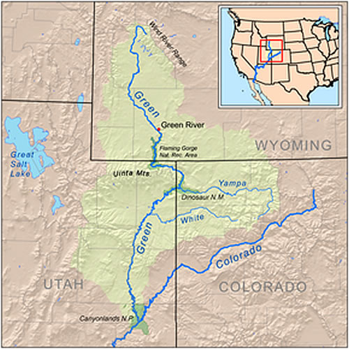 Map of the Green River.
 Square Top Mountain and Lower Green River Lake. Photo by Charmaine Delmatier.
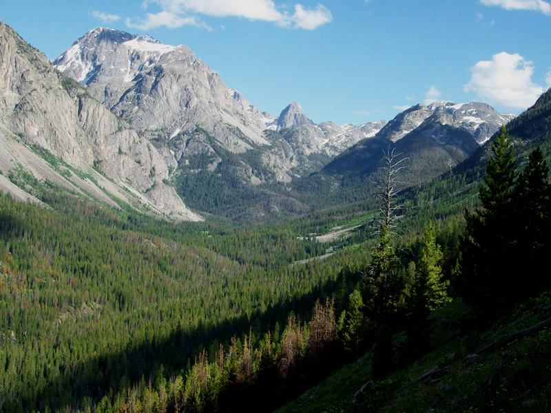 Ice carved valley behind Square Top Mountain, Beaver Park and Three Forks Park. Photo by Charmaine Delmatier.
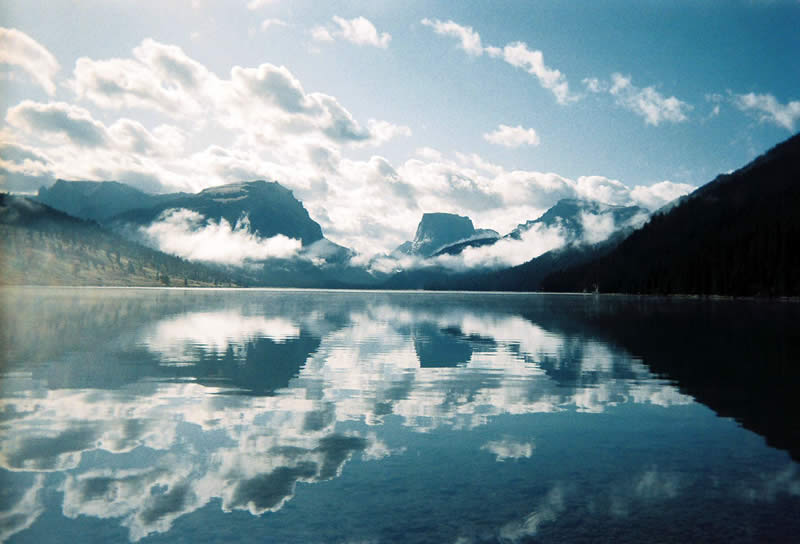 Lower Green River Lake. Photo by Charmaine Delmatier.
"Backbone of America"
 Grand Tetons.
 Ostler Peak, Uinta Mountain Range.
The Rocky Mountains are often referred to as the "Backbone of America" and extend for over 2,000 miles from British Columbia to New Mexico. The Wind River Range extends for 150 miles running north and south in west-central Wyoming and is the apex to the middle Rocky Mountains, which also includes the familiar Teton Mountains Range, the Uinta Mountain Range, the Beartooth Range, and the Bighorn Mountains.
Finis Mitchell Wind River Range Legacy
 Finis Mitchell, Audubon Magazine, 1986.
You cannot mention the Green River Lakes or the Wind River Range without recognizing and paying tribute to its most well known legacy, Finis Mitchell, "The Lord of the Winds." Finis, an explorer and naturalist since childhood, has walked over 15,000 backcountry miles and climbed these mountain peaks 276 times.