Southwestern Region Viewing Area
LOCATION and PHOTOS
 View of Valle Vidal from the southern slope of Little Costilla Peak. A bristlecone pine (Pinus aristata) frames the left side of this picture. Photo source: TheGreatCornHolio.com, © 2005, Greg Gowins.
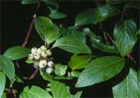
 Red osier dogwood (Cornus sericea) is a low shrub in wet places. The red stems are particularly attractive in winter. Photo source: CalPhotos, © 2005, Bob Sivinski.
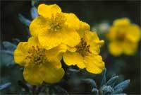
 Shrubby cinquefoil (Dasiphora fruticosa ssp. floribunda) is a common shrub in mountain meadows. Photo source: CalPhotos, © 2005, Bob Sivinski.
Valle Vidal
Forest: Carson National Forest
District: Questa Ranger District
Description: The Valle Vidal (The Valley of Life) unit of the Carson National Forest was donated to the People of the United States by the Pennzoil Company in 1982. This lush mountain basin, located in the heart of New Mexico's Sangre de Cristo Mountains, is home to a magnificent elk herd and other abundant wildlife. The vistas of high peaks, forests, and alpine meadows are breathtaking. With elevations of 7,700-12,584 feet, the plant life is abundant and varied.
As a small sample of the flora, try hunting along marshy areas that grade into dry grassy slopes to find penstemons (Penstemon spp.), paintbrush (Castilleja spp.), cinquefoils (Potentilla spp.), harebells (Campanula rotundifolia), skyrocket (Ipomopsis aggregata), purple geranium (Geranium caespitosum), and monument plant (Frasera speciosa). Look in boggy areas along streams to find gentians (Gentiana spp.), checkermallow (Sidalcea spp.), bog primrose (Primula parryi), shooting star (Dodecatheon pulchellum), and elephant-head lousewort (Pedicularis groenlandica).
The best season for wildflower viewing is July and August when usually brief, but sometimes torrential, afternoon rains green-up the landscape. The Valle Vidal is in a remote sparsely populated part of New Mexico, which results in low summertime visitation for such a beautiful area.
Safety First: Summer storms can cause drastic temperature drops and hypothermia is possible even during the warmest months so always carry protective clothing. If you go for a hike, take a small pack with protective clothing, compass, flashlight, first aid kit, water, and snack foods. Summer storms produce lightning that is very dangerous for hikers on peaks and exposed ridges. If you are going to a high peak, get an early start in the morning and be off the peak by 2:00 p.m. before storms build up. Move to a lower elevation if a storm is approaching.
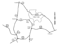
Directions: From Taos, New Mexico, travel north on U.S. Highway 64 to the junction with State Highways 552 and 150. At this intersection, go straight on State Highway 552 (U.S. Highway 64 turns left) through Questa to the Village of Costilla then turn east onto State Highway 196. This highway will change to gravel past the Village of Amelia and become Forest Road 1950. Travel on 1950 east to the junction with Forest Road 1900. Turn right staying on Forest Road 1950 for 10 miles to the junction with Forest Road 1910. Go 1 mile up the hill on Forest Road 1910 to Cimarron Campground, which has 36 campsites for tents and trailers, tables, fireplaces, toilets, and drinking water.
Contact: Carson National Forest, Questa Ranger District, P.O. Box 110, Questa, New Mexico 87556. Phone: (575) 586-0520.
Closest Town: Questa, New Mexico.


