Southern Region Viewing Area
LOCATION and PHOTOS
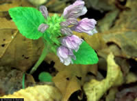
 Meehania, uncommon mint found in rich, mesic sites. Photo by Thomas G. Barnes*.
 Crested Coralroot, a summer flowering orchid. Photo by Thomas G. Barnes*.
 Twinleaf, a spring wildflower associated with rich, mesic sites. Photo by Thomas G. Barnes, University of Kentucky.
* Barnes, T.G., and S.W. Francis. 2004. Wildflowers and ferns of Kentucky. University Press of Kentucky.
War Fork and Steer Fork at Turkey Foot
Forest: Daniel Boone National Forest
District: London Ranger District
Description: War Fork and Steer Fork are streams that sit in limestone valleys. The tops of ridges are sandstone. The combination of bedrock types provides for diverse soils and a diverse flora. A walk along either stream is a pleasant affair, although climbing on the slope is sometimes necessary. Trail 303 leads out of a campground in the area to the north. This trail, with a portion of the Sheltowee Trace National Recreation Trail (#100), makes about a 4-mile loop. Portions of the trail are steep and sometimes muddy (clay soils).
Wildflower viewing: Wildflowers are present in the area throughout the growing season (late March-mid October), but are most spectacular in mid-April. A walk along either of the streams will provide the opportunity to see meehania, bloodroot, large white trillium, red trillium, wood betony, wild ginger, twinleaf, hairy Jacob' ladder, yellow trout lily, foamflower, crested iris, long-spurred violet, wood vetch, showy orchis among other species. Walking the trail loop provides the opportunity to see species more commonly associated with acid soils such as partridgeberry, trailing arbutus and spotted wintergreen. Both pink (mid-April) and yellow (mid-May) lady's-slippers have been seen in the area. False dandelions (Krigia spp.), hawkweeds (Hieracium spp.), Virginia lespedeza, and numerous asters and goldenrods can be found later in the summer. Crested coralroot (Hexalectris spicata) has been found in the area in August. Cranefly orchid (Tipularia discolor) is also present in late summer. The area is home to about 25 species of sedges (Carex).
Safety First: Walking along the creeks can involve walking in the creek at times or climbing upslope. Good, supporting hiking boots are recommended. The trails are slippery in places after rain and portions are steep and narrow. There are small cliffs in the area. Both timber rattlesnakes (uncommon) and copperheads are poisonous snakes in the area. Mosquitoes and black flies are frequently encountered during summer. Poison ivy is abundant in a few areas along the creeks. Long pants are recommended. Branches and logs may be encountered across the trail in places. Areas along the creek are cool, but because summers tend to be warm and humid, portions of the trail may be strenuous for some people. Anyone taking this trail is encouraged to take water.
Directions: From Lexington, Kentucky, take I-75 south to the second Berea exit (Exit 76). Turn left at the top of the ramp on to KY 21. Follow the road up the hill and move into the left hand lane. US 25 will merge with KY 21 from the right. Follow KY 21/US 25 into the center of town. The road passes through Berea College campus. At the main crosswalk (a traffic light and College Square here), take the right turn (the left is US 25 North) traveling a few hundred feet to a 4-way stop. Go straight through passing Union Church on your right and Boone Tavern on the left. You are on KY 21 heading east. Drive for roughly five miles, ending at a T with US 421 in the community of Bighill. Turn right on US 421. You will drive for roughly 18 miles until you reach the intersection with KY 89 North in the center of McKee (the junction with KY 89 South is just as you get to McKee). Turn left onto KY 89, following this for about 3.25 miles. Look for a hard right to the rear near the community of Macedonia. This is a small road. There should be a sign up that points to Turkey Foot. Follow this road for about 0.5 mile, then take a left onto what will become Forest Road 4. (If you pass Pilgrim's Rest Church, turn around and take the other way).You will enter national forest in about 1.2 miles. Follow Forest Road 4 to the bottom of the hill. Turn left on Forest Road 482 to find parking near the campground.
Ownership and Management: U.S. Forest Service, Daniel Boone National Forest, London Ranger District.
Nearest Town: McKee, Kentucky.

