Alaska Region Viewing Area
LOCATION and PHOTOS
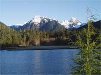
 View up the Starrigavan estuary from Starrigavan Bay at high tide in the winter. Photo by Sandy Russell.
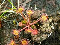
 Sundew (Drosera rotundifolia) an insect eating plant that grows in peat bogs. Tongass National Forest. Photo by Rick Turner.

Starrigavan Recreation Area
Forest: Tongass National Forest
District: Sitka Ranger District
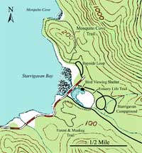
Description: The Starrigavan Recreation Area is located near the historic community of Sitka. It includes a lovely estuary and features a wide range of recreation facilities including camping and picnic sites, an artesian well, the Estuary Life Trail, Forest and Muskeg trail, and the Mosquito Cove trail.
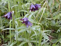
Estuary Life Trail Highlighting the Starrigavan Recreation Area is the estuary bird viewing shelter and the Estuary Life Trail. The beautifully constructed bird viewing shelter is made of heavy timbers from locally grown trees including Sitka spruce, western hemlock, and Alaska yellow cedar. It is nestled at the edge of the forest overlooking the entire estuary. The shelter is located at the beginning of the quarter-mile long Estuary Life Trail, a boardwalk trail running along the edge of and through the estuary. Estuary vegetation is dominated by Lyngby sedge, Bering hairgrass, and bluejoint grass. During the late spring and early summer, blooming flowers including yellow paintbrush, yarrow, wild geranium, buttercup, chocolate lily, and cinquefoil brighten the upper beach meadows adjacent to the estuary.
The Forest and Muskeg Trail This trail is 3/4 miles long and begins on the far end of the Estuary Life Trail near the Starrigavan Creek footbridge. The trail climbs about 150 feet up a small hill, is essentially level in the muskeg area, and drops back down to sea level. It is surfaced with fine gravel through the forest and is a wooden boardwalk across the muskegs.
The first portion of the trail is a gentle climb up through the hemlock forest where recent windstorms have broken and toppled huge western hemlock trees. The forests of southeastern Alaska are renewed by the effects of wind, rather than by the effects of fire. Dwarf mistletoe grows in many of the hemlock trees; instead of seeing the mistletoe, one sees the results of this tiny parasitic plant. Look high in the trees for the gnarled branches (witch’s brooms) caused by the mistletoe infections. At the top of the hill, as the trail approaches the muskeg, the forest vegetation becomes sparser, yet more species rich, with mountain hemlock, Alaska yellow cedar, and stunted lodgepole pine.
The boardwalk trail meanders through the muskegs. Muskeg is a colloquial term for bogs, which are abundant in southeastern Alaska. Sphagnum moss and sedges form a spongy vegetation mat in these essentially treeless areas. Occasional irregularly sized small pools and a few gnarled, stunted conifers break the hummocky, low vegetation; these features lend an Oriental garden atmosphere to the place. Low-growing evergreen shrubs, such as Labrador tea, bog laurel, bog rosemary, crowberry, and cloudberry are common. Wildflowers, such as bog orchids, Jeffery shooting star, pond lily, swamp gentian, deer berry, bunchberry and the insect-eating sundew are abundant in the muskeg.
Leaving the bogs, the trail continues down through the forest to a trailhead at Halibut Point Road near the Old Sitka Historical site. To return to the Starrigavan Recreation Area, one can walk along the road, or walk back on the Forest and Muskeg Trail.
Mosquito Cove Trail This trail begins at the northwest end of the Recreation Area’s bayside picnic loop. The 1 ½ mile-long Mosquito Cove loop trail sneaks along the shore of Starrigavan Bay just inside the forest edge. Large, old western hemlock and Sitka spruce trees form an impressive canopy over most of the trail. Understory vegetation generally consists of blueberries, red huckleberries, and rusty Menziesia. In most places, the forest floor is carpeted with mosses and liverworts, punctuated by lady fern, shield fern, and deer fern. There are several places near the beginning of the trail offering access to gravelly beaches. From these beaches, one can see Sitka alder, beach rye grass, sea beach sandwort and other shoreline plants. There are quite a few wet rock faces along the trail, especially approaching Mosquito Cove. These are excellent places to see plants such as the beech fern, maidenhair fern, deer fern, and the strange-looking fir clubmoss.
Skirting the southeast shore of Mosquito Cove, the trail provides views across Katlian Bay to the Lisianski Peninsula. Bering hairgrass, bluejoint grass, and Lyngby Sedge dominate the vegetation adjacent to the beach at the head of Mosquito Cove.
The Mosquito Cove inlet stream parallels the trail as it heads southeast back to the trailhead. This portion of the trail gradually climbs about 100 feet and crosses a low pass. Falling trees created openings in the forest canopy; these openings admit more light to the forest floor, resulting in a more diverse flora through this part of the forest. One of these large trees was used to bridge the stream. Western hemlock dominates this forest, with all life stages revealing themselves, from seedlings to huge dead snags.
The vegetation changes at the crest of the pass, becoming sparser. The ground is poorly drained, but the plants are adapted to this drainage situation. They include yellow skunk cabbage, sphagnum moss, and Alaska yellow cedar. As the trail drops down to the trailhead, it switches back down through an open forest of Western hemlock.
This is a well-marked loop trail, so the loop can easily be walked in either direction.
Safety First: Be prepared for wet and chilly weather at any time of the year. Trail treads and Boardwalks can be slippery in wet weather, so be sure to watch your step.
Be cautious of brown bears in the area. They are most commonly present in the late spring when they are grazing on the estuary’s sedges and grasses, and late in the summer when they are fishing for salmon in the Starrigavan estuary and streams between there and Mosquito Cove. NEVER approach a bear under any circumstances. If you are lucky enough to see one, view it from a distance.
Directions: From downtown Sitka, drive 7.5 miles north on Halibut Point Road, pass over the bridge crossing the Starrigavan estuary. Turn at the next right for the estuary bird viewing shelter and Forest and Muskeg trail. Turn at the last left before the end of the road and go to the far end of the campground to reach the Mosquito Cove trail.
The Alaska Marine Highway terminal is about ½ mile west of the recreation area and about ¼ mile west of the west end of the Forest and Muskeg trail.
Ownership and Management: USDA Forest Service, Tongass National Forest, Sitka Ranger District (907) 747-6671.
Closest Town: Sitka, Alaska.


