Rocky Mountain Region Viewing Area
LOCATION and PHOTOS
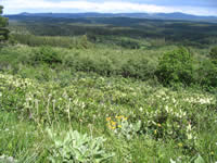
 View from Cement Ridge with arrowleaf balsamroot (Balsamorhiza sagittata) in the foreground. Photo by K. Zacharkevics.
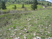
 Rocky soils weathered from igneous and metamorphic bedrock underlay this montane grassland. Photo by K. Zacharkevics.
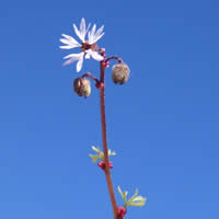
 Bulbous woodland star (Lithophragma glabrum) is a member of the Saxifrage Family. Photo by K. Zacharkevics.
Cement Ridge
Forest: Black Hills National Forest
District: Bearlodge Ranger District
Description: Cement Ridge is located on the Bearlodge Ranger District of the Black Hills National Forest, Crook County, Wyoming, one mile west of the South Dakota state line. Cement Ridge is a rocky montane meadow supporting primarily native plant species. Due to the vantage point from 6,647 feet, a fire lookout was placed on Cement Ridge in 1937-1938. (The tallest peak in the Black Hills is 7,242 feet). The Cement Ridge montane meadow sits on an igneous intrusion of the Crystalline Core, with rocky soil derived from igneous and metamorphic rock.
Viewing Information: The Black Hills are known to be a convergence of "where East meets West". The Black Hills are also referred to as "an island in the plains". Looking out from this open high meadow, Rocky Mountain species such as ponderosa pine (Pinus ponderosa) and aspen (Populus tremuloides) can be seen, along with the northern species paper birch (Betula papyrifera). Looking down, the meadow is mostly made up of grasses and forbs such as arrowleaf balsamroot (Balsamorhiza sagittata), which is at its easternmost distribution in the Black Hills; pasqueflower (Anemone patens) which is a relict of the last glaciation; shooting star (Dodecatheon pulchellum) a western representative, and larkspur (Delphinium bicolor), a northern species. The best wildflower viewing is when the Rocky Mountain forbs are blooming in late June/early July. Beautiful views can be seen any time, weather permitting.
Safety First: Rapid weather changes can occur year-round. Snow is possible September through May. Be prepared for quickly developing thunderstorms in June, July, and August. These storms often bring hail and very strong winds. While driving up to Cement Ridge, observe the broken trees resulting from a tornado during the early 1990s. Summer temperatures can be high, 90 to 100 F., so be sure to bring sunscreen and water. There is a place to park and a public restroom at the summit.
Directions: Please obtain a map of the area, as navigating without one can be tricky. Route 1 from Spearfish, South Dakota: proceed southwest on Forest Service Road 134. Go west (right) on 105, turn north (right) on 804 and north (right) again on 850. Route 2 from Sundance, Wyoming: proceed east on I-90, exit on the Moskee Road, Exit 191. Proceed south on the Moskee Road (County Road 141) to the intersection with the Grand Canyon Road (Forest Service Road 875), turn east (left) on 875, east (left) on 804 (Rattlesnake Canyon Road), and then north (left) on 850. Travel time for both routes is approximately one hour. Both routes contain gravel roads.
Contact: Bearlodge Ranger District, Sundance, Wyoming, (307) 283-1361; or Northern Hills Ranger District, Spearfish, South Dakota, (605) 642-4622.

