

Pacific Northwest Region Viewing Area
LOCATION and PHOTOS
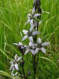 Star Gentian (Swertia perennis), a rare member of the Gentian family in wooded wetlands near the Saddle Camp Trail. Photo by Mark Darrach, Umatilla National Forest.
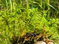 Blandow’s Moss (Helodium blandowii), a rarely seen moss species in seeps and springs near Saddle Camp Trail. Photo by Mark Darrach, Umatilla National Forest.
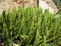 Lemmon’s hollyfern (Polystichum lemmonii), an infrequently seen fern species that is always confined to ultramafic rock geologic settings. Photo by Mark Darrach, Umatilla National Forest.
Olive Lake, Saddle Camp Trail #3035, and Blue Mountain Trail #6141
Forest: Umatilla National Forest
District: North Fork Ranger District
Description: The hike from Olive Lake south up the relatively easy-to-negotiate Saddle Camp Trail is a botanically rewarding and interesting experience through some of the finest scenery on the Umatilla National Forest. At the start of the hike at Olive Lake, the elevation is 6000 feet. If you are adventurous and continue up to the Blue Mtn. Trail, the elevation tops out at about 7100 feet. From there you can turn around and return to Olive Lake, or, if you are backpacking overnight, you can continue south- eastward on the Blue Mtn. Trail as it ascends slowly up the crest of the Greenhorn Mountains to about 7500 feet. The area is a mix of moist coniferous forest composed of Engelmann spruce, subalpine fir, and lodgepole pine. As the Saddle Camp Trail ascends to the Blue Mountain Trail, the forest becomes drier with lodgepole pine the primary tree species. Higher ridges to the south sport our only populations of the now federal Endangered Species Act candidate tree species, whitebark pine. Along the way, you will note lovely meadows that harbor over 25 species of sedge (Carex sp.). The hike up the Saddle Mtn. trail takes the viewer along the only area of the forest that was glaciated during the Pleistocene epoch.
Wildflower viewing: The best time to explore the area for wildflowers and other plants is in mid-July. By this time the ‘sweet spot’ in the annual bloom should be occurring. Along the way, you will note a large meadow to your left with many sedge species. Amongst these is the rarely seen Buxbaum’s sedge (Carex buxbaumii). Other interest- ing species in and along the edges of the meadow include primitive grapeferns in the genus Botrychium, star sedge (Carex echinata), the infrequently seen alpine ladyfern (Athyrium americanum), and the rarely seen, and showy, moss species Blandow’s moss (Helodium blandowii). Other very attractive species that may be seen along the way, particularly if you get off the trail and poke around a bit, include the fantastically beautiful explorer gentian (Gentiana calycosa), and our rarely seen narrow-leafed alpine shooting-star (Dodecatheon alpinum). As you climb higher up the trail and into the heart of the Greenhorn Mountains, you may encounter the odd fern species Lemmon’s hollyfern (Polystichum lemmonii). This species grows only on strange rocks known as ultramafics. These rocks, ultimately from Earth’s mantle, are high in elements that are toxic to most plants, so those few species that ultimately find a way to grow in the presence of metals such as nickel, chromium, and cobalt are often quite unusual, and sometimes very rare indeed.
Directions: From Pendleton, Oregon drive south on U.S. highway 395 until you encounter the north fork of the John Day River. Just as you are about to cross the bridge to the south side of the river the USFS road #10 stretches off to the east. Take the 10 road all the way until you reach Olive lake – about 26 miles – and then drive to the end of the road at the trailhead on the south end of the lake.
Alternatively, you can reach the trailhead from the little town of Granite, Oregon by driving 12 miles southwest of Granite, Oregon, via Forest Road 52 to Granite (paved), then west on Forest Road 13 (paved), then west on Forest Road 10 (gravel for 9 miles).
Ownership and Management: USDA Forest Service, Umatilla National Forest, North Fork Ranger District.
Closest town: Granite, Oregon.