

Misty Fjords National Monument
 In 1978, President Jimmy Carter proclaimed over 2,200,000 acres as the Misty Fjords National Monument. In 1980, this acreage got reduced to 2,142,243 acres but was now congressionally designated as Misty Fjords National Monument Wilderness and still remains the largest wilderness area on the Tongass National Forest. Due to this designation, it is now strategically managed to continue the preservation of this undeveloped, enduring ecosystem for the enjoyment of present and future generations.
What will I see?
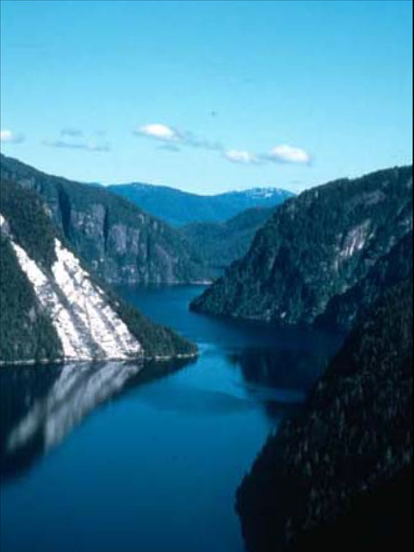
17,000 years ago Misty Fjords National Monument would have been covered with only one thing, massive bodies of ice. As the ice disbanded, it carved away gloriously long, deep fiords with cliffs that rise for thousands of feet. They are considered the skyscrapers of this wilderness wonderland. Travel either by boat or floatplane in Behm Canal, the major waterway through the heart of the area, and sightings of killer whales, porpoises, mountain goats, and bears could be possible. Step on the edge of the wilderness boundary, walk inward, and be surrounded by Sitka spruce, western hemlock, and cedar trees. Unique geological features such as mineral springs and volcanic lava flows can be found deep within this wilderness monument. Voyage closer toward the Canadian border through the many king salmon spawning streams, or through the sky and see what remains of the ice (now only in the form of glaciers) that once created this current mystic landscape.
What should I know?
There are thirteen public recreation cabins, five three-sided shelters, and ten trails that provide altogether twenty miles of hiking activity.
Tongass National Forest is the largest, intact coastal rainforest in America. Misty Fjords is a piece of this treasure and is set aside for all visitors – now and in the future. To insure that this area is left unimpaired for future use, practice the following Leave No Trace principles.
Plan ahead and be prepared for extreme weather conditions, and emergencies.
Travel and camp on durable surfaces like uplifted gravel or sand beaches. If forested areas need to be used, disperse use to prevent the creation of campsites and trails and avoid places where impacts are just beginning.
Dispose of waste properly. Pack out all trash, leftover food, and toilet paper. Use bathroom facilities when available. During appropriate conditions dispose of human waste in the intertidal zone. If camping in upland forests dispose of solid waste by digging a cathole 6 to 8 inches deep located at least 200 feet from water or campsite.
Leave what you find. A few historical sites and artifacts are within this wilderness. Examine but do not touch cultural or historical structures and artifacts. Do not build structures or furniture with live trees.
Minimize campfire impacts. Use a lightweight stove when possible. When a campfire is necessary, keep fires small. Build a fire below mean high tide, or when in a forested area, build a mound fire or use a fire pan to avoid damaging the ground vegetation. Stay away from boulders or tree bases to avoid long lasting black scars.
Respect wildlife and other visitors in the surrounding area.
Other Forest Service-Managed National Monuments
Admiralty Island National Monument, Tongass National Forest, Alaska
Baaj Nwaavjo I'tah Kukveni—Ancestral Footprints of the Grand Canyon National Monument, Kaibab National Forest
Berryessa Snow Mountain National Monument, Mendocino National Forest, California (co-managed with the Bureau of Land Management)
Browns Canyon National Monument, Arkansas River valley, Colorado
Chimney Rock National Monument, San Juan National Forest, Colorado
Giant Sequoia National Monument, Sequoia National Forest, California
Misty Fiords National Monument, Tongass National Forest, Alaska
Mount St. Helens National Volcanic Monument, Gifford Pinchot National Forest, Washington
Newberry National Volcanic Monument, Deschutes National Forest, Oregon
San Gabriel Mountains National Monument, Angeles National Forest, California
Sand to Snow National Monument, San Bernardino National Forest, California
Santa Rosa & San Jacinto Mountains National Monument, San Bernardino National Forest, California (co-managed with the Bureau of Land Management)