

Maps
Forest Service Maps

FREE DOWNLOADABLE MAPS
Looking for a map to help plan your trip to a national forest or grassland? You can access downloadable maps at a variety of scales to help you get started. These maps are a great no-cost starting point to get to know your destination.
Forest Service Digital Maps
Forest Service Digital Maps cover all lands administered by the agency. They are available at a variety of scales, and at the 1:100,000 scale cover the continental U.S. These maps are available as a digital download or a scalable, online basemap.
Interactive Visitor Map
The Interactive Visitor Map is an online application that provides information on Forest Service roads, trails, recreation sites, wilderness areas, and wild and scenic rivers across our national forests and grasslands. You choose the type of recreational opportunity you’re interested in, and the map will filter sites based on your selection.

A Forest Service map is a tool you need to safely navigate national forests and grasslands. They can be great gifts for friends and family. Map lovers might enjoy a framed map as wall art.
There are several types of maps available to you.
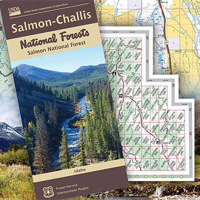
Forest Visitor Maps
Forest Visitor maps have rich content specific to each forest and grassland, providing information on attractions, facilities, services, and recreational opportunities. Features include recreational sites, such as campgrounds, trails and scenic areas, roads, forest boundaries and public/private land distinctions, and legends and symbols for easy navigation. These maps are professionally printed with tear resistant and waterproof synthetic paper to improve durability during your recreational experience.
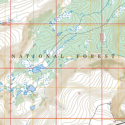
National Forest Atlases
National Forest Atlases are full-color printed atlases containing 8.5-inch by 11-inch topographic quadrangle maps scaled at 1 inch to 1 mile. These are professionally printed maps and can be found at many locations where Forest Service maps are sold.
The atlases are especially useful for outdoor enthusiasts who want a convenient map with a comprehensive view of the forest.
Wilderness Maps
Wilderness Maps are specialized topographic maps that provide detailed information about the hundreds of designated wilderness areas managed by the Forest Service. The maps are designed for hikers, backpackers, equestrians and anyone venturing into these remote, undeveloped public lands where nature still calls the shots and motorized access is restricted.
These maps are more detailed than visitor maps and are especially useful for non-motorized recreation, like hiking, horseback riding and backcountry camping.
Each map covers all or part of one wilderness area, and the scale is generally 1 inch to 1 mile (1:63,360). These maps are professionally printed on tear and water-resistant paper.
Get Your Paper Maps
Forest Visitor Maps, Forest Atlases and Wilderness maps may be purchased online through the U.S. Geological Survey Map Store. Forest Visitor Maps also may be purchased using our Map Finder application. Selected hard copy maps and atlases may be purchased at national forest or grasslands offices. Call ahead to ask about availability.
In addition to these resources, many Forest Service maps, including the visitor maps, also are available for purchase as georeferenced PDFs on Avenza, which may be used on most mobile devices.

Your guide to motorized adventures
Whether cruising forest roads in a 4x4, hitting the trails on an ATV or riding a snowmobile on groomed trails, you need a specialized map as your essential companion for safe and legal on national forests and grasslands.
There are two types of specialized maps - motor vehicle use maps, referred to as MVUMs, and over snow vehicle use maps, or OSVUMs.
How the maps help you
Motor vehicle use maps show designated roads, trails and areas for motor vehicle use, including highway-legal vehicles and off-highway vehicles.
Over snow vehicle use maps show designated roads, trails and areas open to over snow.
The maps contain information about seasonal use, distance allowances, and other travel rules and regulations.
Routes not shown on the motor vehicle maps are not open to public motor vehicle travel. The maps are important to have because routes may not always have signs designating them for motorized use.
Why it matters
Using these maps helps you recreate responsibly while protecting natural resources and ensuring continued access for all. Do your part by picking up or downloading your free map from the forest or grassland before heading out is how you can “know before you go” where you can ride responsibly.
A route or area not listed on the motor vehicle use maps is not open to motorized travel—even if it appears usable. The map is important to have because routes may not always have signs designating them for motorized use. The same applies to over snow vehicles and over snow vehicle use maps.
You are responsible
It is your responsibility to know which routes and areas are designated for motor vehicle use. That means you should always carry a motor vehicle use map or over snow vehicle use map for the area you are visiting. Use of roads, trails and areas shown on motor vehicle or over snow vehicle use maps - or both - are permitted. Not following a map will likely result in a citation.
These black-and-white maps do not include topographic details, but they serve as a key reference for identifying where motorized vehicles are legally allowed on national forests and grasslands. Use them alongside a Forest Service base map, forest visitor map, or another detailed map that displays the information needed for successful navigation.
Printing motor vehicle use maps
National forests and grasslands are required to post maps online. Check the website of your forest or grassland destination. On a forest or grassland website, click on Visit, then Visitor Maps and Guides to find the map you need.
The maps also may be found at visitor centers. Maps are updated as needed. Ensure you download or print a map each time you need it. To print a map:
Select the map for the area you would like to visit.
Print a map or a portion of a map by zooming in on the area you will visit.
Select FILE then PRINT to save a PDF version. More options are available under PAGES TO PRINT.
What the map shows
Route designations and vehicle classes:
Roads open to highway legal vehicles only
Roads open to all vehicles, licensed and unlicensed
Trails open to vehicles 50 inches or less in width, such as all-terrain vehicles and motorcycles
Trails open to all full-size vehicles but intended for 4x4s because trails may be rugged and narrow
Trails open to motorcycles only
Stay safe, act responsibly
Roads, trails, and areas are open to multiple uses. Anticipate encounters with other users and wildlife. Operate vehicles at safe speeds and using appropriate safety gear. Review state law requirements for safety equipment and operation of motor vehicles.
Some routes may be open only during certain times of the year and for certain vehicle types for various reasons. Route markers exist at the entrance to a road or trail and include route numbers that match those shown on motor vehicle use maps and over snow vehicle use maps.
Your guide is a current motor vehicle use map or over snow vehicle use map.
Forest Service geospatial data easily available
The Forest Service maintains a wide range of geospatial datasets and ArcGIS Online applications that support diverse projects and programs. To make this information easier to access, we’ve created an open data site where partners and the public can explore our data by category.
You can use these resources alongside your own data to build maps, apps, and informational products.
Visit the Geospatial Data Discovery hub to browse public datasets. Be sure to scroll to the section labelled “More Applications” for a curated selection of interactive tools and applications.


Simplified Public Access
Knowing where you can go and what you can do on federal public lands helps you plan a safe, enjoyable, and stress-free trip. In 2022, the Modernizing Access to Our Public Land Act (MAPLand (PDF, 200 KB)) was passed to help visitors more easily understand how to reach and enjoy public lands regardless of which federal agency manages the land.
MAPLand requires the Forest Service and five other land management agencies to create clear and consistent mapping data that shows where recreation opportunities are available across all federal lands.
You can now explore available federal MAPLand-related databases on the GeoPlatform.gov site, published by the U.S. Geological Survey (USGS).
Our Commitment
In April 2026, the Forest Service released the first set of MAPLand-required data: public access easements. Federal easement data identifies where the Forest Service holds easement rights on non-Forest Service lands, making it easier for hunters, anglers and others to legally access public lands.
More information will be added by spring 2027 for roads, trails, recreation sites, and recreational shooting and hunting closure areas. Data will be updated at least twice per year to ensure accuracy and timeliness.
Why MAPLand matters
Before MAPLand, access information was scattered and inconsistent. Now, agencies are working together to make digital data and maps easier to understand so you can spend more time exploring and less time figuring out the rules.
Expanding recreation access to National Forest System lands is one of the Forest Service’s top priorities. Making this access information available strengthens the public’s understanding of how and where they can enjoy their national forests and grasslands.