

Mount St. Helens National Volcanic Monument
About This Destination
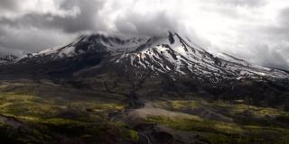
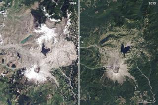
At 8:32 Sunday morning, May 18, 1980, Mount St. Helens erupted, shaken by an earthquake measuring 5.1 on the Richter scale, the north face of this tall symmetrical mountain collapsed in a massive rock debris avalanche. In a few moments this slab of rock and ice slammed into Spirit Lake, crossed a ridge 1,300 feet high, and roared 14 miles down the Toutle River.
The avalanche rapidly released pressurized gases within the volcano. A tremendous lateral explosion ripped through the avalanche and developed into a turbulent, stone-filled wind that swept over ridges and toppled trees. Nearly 150 square miles of forest was blown over or left dead and standing.
At the same time a mushroom-shaped column of ash rose thousands of feet skyward and drifted downwind, turning day into night as dark, gray ash fell over eastern Washington and beyond. Wet, cement-like slurries of rock and mud scoured all sides of the volcano. Searing flows of pumice poured from the crater. The eruption lasted 9 hours, but Mount St. Helens and the surrounding landscape were dramatically changed within moments.
A vast, gray landscape lay where once the forested slopes of Mount St. Helens grew. In 1982 the President and Congress created the 110,000-acre National Volcanic Monument for research, recreation, and education. Inside the Monument, the environment is left to respond naturally to the disturbance.
What Will I See?
Surviving plants and animals rise out of the ash, colonizing plants catch hold of the earth, birds and animals find a niche in a different forest on the slopes of Mount St. Helens.
The volcano continued to erupt until 1986, violently at first, then quietly building a lava dome. Thick pasty lava eruptions oozed out, each one piling on top of the next, like pancakes in a sloppy pile. The lava dome is now 920 feet high. The United States Geological Survey scientists continue to monitor the volcano for earthquakes, swelling, and gas emissions.
What Should I Know?
A good place to begin your visit is at one of the Monument's visitor centers or information stations. Interpretive staff are available to answer your questions and help you plan your visit. Ask about the schedule of interpretive walks, talks, and theater presentations that share the geologic, biologic, and cultural history of the area. Visit our recreation page to find out where you can hike, bike, fish, play in the snow and more.
Numerous viewpoints and miles of trails have been created for you to explore by car and foot. During the summer Forest Service interpreters lead a wide range of activities, from short walks to amphitheater presentations, to help you understand and enjoy this area. Discover the wonder of winter around Mount St. Helens, where many cross-country ski and snowmobile trails are available.
Each year thousands of climbers make the journey to the crater rim. Permits are required above 4,800 feet year-round.
Other Forest Service-Managed National Monuments
Admiralty Island National Monument, Tongass National Forest, Alaska
Baaj Nwaavjo I'tah Kukveni—Ancestral Footprints of the Grand Canyon National Monument, Kaibab National Forest
Bears Ears National Monument, Manti-La Sal National Forest, Utah (co-managed with the Bureau of Land Management)
Berryessa Snow Mountain National Monument, Mendocino National Forest, California (co-managed with the Bureau of Land Management)
Browns Canyon National Monument, Arkansas River Valley, Colorado
Camp Hale-Continental Divide National Monument, White River National Forest, Colorado
Chimney Rock National Monument, San Juan National Forest, Colorado
Giant Sequoia National Monument, Sequoia National Forest, California
Misty Fiords National Monument, Tongass National Forest, Alaska
Mount St. Helens National Volcanic Monument, Gifford Pinchot National Forest, Washington
Newberry National Volcanic Monument, Deschutes National Forest, Oregon
San Gabriel Mountains National Monument, Angeles National Forest, California
Sand to Snow National Monument, San Bernardino National Forest, California
Santa Rosa & San Jacinto Mountains National Monument, San Bernardino National Forest, California (co-managed with the Bureau of Land Management)
Sáttítla Highlands National Monument, Modoc, Shasta-Trinity, and Klamath national forests, California
Sources: USDA Forest Service; U.S. Geological Survey, U.S. Fish and Wildlife Service, National Park Service, Carnegie Institution for Science.