

San Gabriel Mountains National Monument
On May 2, 2024, President Biden expanded the San Gabriel Mountains National Monument. This designation enlarges the monument by 105,919 acres, and together with the established monument designated by President Obama in 2014, the San Gabriel Mountains National Monument stretches more than 452,000 acres. The monument protects rich cultural history, striking geologic features, and vibrant ecological diversity.
The designation will help ensure these lands remain a benefit for all Americans through tribal antiquities that provide a glimpse into Indigenous cultures who call this area their homelands, an observatory that brings the world the cosmos, habitat for rare and unique plants and animals, and outdoor recreation opportunities for millions of visitors each year.
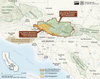
The monument expansion includes areas of the Angeles National Forest that stretch south and west from the original National Monument boundary to the forest boundary near the foothill communities. This expansion will protect abundant biodiversity, historical sites, distinctive geology and the traditional homelands of many Indigenous people.
For thousands of years, a mosaic of Indigenous people, including the people known as the Gabrielino, Kizh, or Tongva, and the Chumash Kitanemuk, Serrano, and Tataviam peoples occupied the expansion area. Today, their descendants continue to use the area for ceremonial purposes, as well as for collecting traditional plants important for basketry, food, and medicine.
Visitors to the expansion area will see the ruins of grand recreation resorts perched atop the San Gabriel peaks, as well as remains of the railway trestles for the historic Mount Lowe Railway. In contrast to these historic sightseeing relics, visitors will also see remaining facilities of a Nike missile site built to protect the U.S. during the Cold War. Also in the expansion area are the sites of 19th century homesteads including the El Prieto Canyon homestead of Robert Owens, a formerly enslaved person who built a thriving wood and building supply business and became the wealthiest African American in Los Angeles County in 1865. Visitors can hike sections of the Gabrielino National Recreation Trail, which incorporates preexisting ancient Indigenous trails.
In addition to extensive historical resources, the area reflects massive geologic forces occurring over hundreds of millions of years that created an exceptional landscape, providing views deep into the ancient earth. Near Gold Canyon, visitors can see paleontological resources, particularly invertebrate fossils such as oysters and gastropods.
The expansion area is rich in biodiversity, including more than 500 native plants and fungi, across diverse ecosystems including from conifer forests to coastal sage to rare perennial streams and riparian areas. The area is home to many endangered, threatened, and native species such as the Arroyo toad, steelhead trout, coastal California gnatcatcher, and California condor.
The area also provides important connectivity to enable wildlife to move from the foothills in the south to the soaring mountains in the north, as well as Bear Divide which funnels thousands of migratory birds through a narrow pass along the Pacific Flyway.
The San Gabriel Mountains National Monument is within 90 minutes of more than 15 million people living in the Los Angeles Basin, one of the most ethnically diverse and populated areas of the country. The monument is a natural respite for the area, boasting year-round, recreational activities including birding, hiking, biking, hunting, fishing, and cross-country skiing.
The monument includes a portion of the impressive, 2,500-mile-long Pacific Crest National Scenic Trail, archeological sites that are eligible or potentially eligible for listing on the National Register of Historic Places, and the ruins of once grand resorts, as well as the Mount Lowe Railway, which brought visitors from the foothill communities of Los Angeles up to the mountain resorts. Once considered a popular tourist attraction in Southern California, the railway operated from 1893 to 1936 and carried 3.1 million visitors during this time. Today's visitors who hike to Echo Mountain will see portions of the historic railroad bed and crossties, a platform, trestle foundations, and scattered remains of the powerhouse's massive cogwheel or "bullwheel" used to pull the incline car up the mountain.
The 10,064-foot Mount San Antonio – commonly known as Mount Baldy for its lack of trees – is the highest point in Los Angeles County. The lower section of the mountain becomes sparsely clustered with white fir, sugar pine, lodgepole pine, and ponderosa pine. Upper portions, beneath the treeless alpine zone, consist strictly of lodgepole pine forest.
The nearly 10-mile-long Mount Baldy Notch Trail is one of the most popular trails on the mountain, although the challenging route contains some steep sections on loose gravel and is only recommended for experienced hikers.
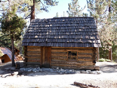
The Mount Baldy Visitor Center educates thousands of students and teachers each year in environmental education. The center includes a 1920s schoolhouse, reproductions of a gold-mining camp and a Native American (Tongva-Gabrielino) village.
The Devil’s Punchbowl is a scenic geological formation situated along the northern slopes of the San Gabriel Mountains. The punchbowl is characterized by a 300-foot-deep canyon known as a plunging syncline, or a compressed V-shaped fold within the earth’s sedimentary rock. The one-mile-long Devil’s Punchbowl Loop Trail is a family-friendly hiking route that provides incredible views of the famous canyon and surrounding mountain peaks.
Named after a nearby city, Ontario Peak is one of many high mountain peaks located within the Cucamonga Wilderness section of the San Gabriel Mountains. The 8,696-foot-tall summit is renowned among outdoor enthusiasts for the challenging hiking trail that leads up to it. Ontario Peak Trail takes hikers along a 12.1-mile roundtrip route that features plenty of gorgeous mountain vistas. The trail is often quite busy, so it is recommended that hikers arrive early for their ascent.
The San Gabriel Mountains National Monument contains spectacular biodiversity, including more than 500 native plants and fungi, and dozens of endangered, threatened, rare or sensitive species including the California condor, Nelson’s bighorn sheep, California spotted owl, and the Southern California legless lizard.
Despite its proximity to urban Los Angles, the Monument includes four wilderness areas – Magic Mountain, Pleasant View Ridge, San Gabriel, and Sheep Mountain, and the Arroyo Seco, San Dimas, San Gabriel, Sheep Mountain, Strawberry Peak, and West Fork Inventoried Roadless Areas.
The rivers of the San Gabriel Mountains not only provide drinking water but are vital in the support of native fish, animals and plants and provide critical habitat for threatened or endangered species such as the mountain yellow-legged frog, Arroyo chub fish, southwestern pond turtle and slender-horned spineflower.
In addition to rivers, the San Gabriel Mountains contain two scenic lakes, both formed by the area's remarkable geologic forces. The alpine Crystal Lake, found high in the mountains, was formed from one of the largest landslides on record.
Various types of chaparrals, oak woodlands, and coastal sage scrub are just some of the diverse vegetation zones that represent a portion of the rare Mediterranean ecosystem found in just over two percent of the world’s land areas. Many plants endemic to Southern California or to Los Angeles County exist in the Monument including, Plummer’s mariposa lily, San Gabriel manzanita, San Gabriel leather oak, San Gabriel Mountains sunflower, Mount Gleason paintbrush, as well as the chaparral yucca that is part of an extraordinary, mutually beneficial partnership with the interdependent yucca moth.

Science and research have been, and continue to be, an integral part of the monument area, from the heavens to the earth below our feet.
Astronomer Edwin Powell Hubble, working from the Mount Wilson Observatory, is credited with making some of the most striking discoveries in modern astronomy. Albert Michelson, America's first Nobel Prize winner in a science field, conducted an experiment that provided the first modern and truly accurate measurement of the speed of light. These findings forever changed the way astronomers looked at the skies.
The steep and rugged San Gabriel Mountains are one of the fastest-growing mountain ranges in the world. They are a rare Transverse Range formed from millions of years of geological movement and creating an unusual east-west orientation, instead of the more typical north-south orientation of mountain ranges.
Around Mount Lowe, near Mendenhall Peak, visitors can see on the surface the bands, swirls, and twisting of rocks up to 1.8 billion years old, which makes the area a hotbed for geological study and a natural classroom for the public.
The San Dimas Experimental Forest, established in 1933, contains some of the earliest and longest records from continuously monitored, experimental watersheds in the U.S. It is the only research forest in Southern California, and many of the facilities were constructed by the depression-era Civilian Conservation Corps and Work Projects Administration labor programs. In 1976, the United Nations Educational, Scientific and Cultural Organization’s Man and the Biosphere Program recognized the San Dimas Experimental Forest as a “Biosphere Reserve.”
For thousands of years, the monument area has sustained a mosaic of Indigenous people, including the people known as the Gabrielino, Kizh, or Tongva, and the Chumash Kitanemuk, Serrano, and Tataviam peoples.
The displacement of these peoples from the area began between 1770 and 1816, when Spanish missionaries forcibly assimilated the region's Indigenous families into surrounding missions and continued into the 20th Century. Today, their descendants are part of Tribal Nations and other Indigenous peoples in the region, some of whose members continue to use the area for ceremonial purposes, as well as for collecting traditional plants important for basketry, food, and medicine.
Today, the area is home to the non-profit, private Haramokngna American Indian Cultural Center, and members of area tribes are active in restoration and education including through the Fernandeño Tataviam Band of Mission Indians’ Tiuvac’a’ai’ (Healthy Lands) Tribal Conservation.
Mining made its way to the San Gabriel Mountains in the 19th century, following the discovery of gold in Placerita Canyon in 1842. The historic mining town of Eldoradoville, located along the East Fork of the San Gabriel River, had at its peak in 1861 a population of over 500 miners, with general stores, saloons, and dance halls along with numerous mining camps of tents, wooden shacks, and stone cabins along the river.
The San Gabriel Mountains contain evidence of Euro-American settlers who used these lands for mineral resources, timber, building materials, and water. Evidence of the Great Hiking Era can be found in Switzer’s Camp, a resort camp which played host to Henry Ford, Clark Gable, Shirley Temple, and numerous other celebrities. While the site burned down and bore subsequent flooding, foundations and rockwork from the resort can still be seen.
Also on the monument are four Nike Missile sites which played a vital role in U.S. national defense during the Cold War era as among the 300 Nike missile sites constructed across the country from 1955 to 1958, which were intended to serve as the last line of defense against Soviet bomber planes. The Los Pinetos Missile Site is perhaps the best-preserved Nike missile site in the Los Angeles area and is unusual because its launch, administrative, and battery control facilities are located within a single line-of-sight.
Frequently Asked Questions
What is a national monument?
A national monument is a designation given to a protected area of federal land. National monuments encompass landscapes and objects of beauty, diversity, and historic and scientific interest ranging from rugged California coastlines to vividly hued desert canyons to precious cultural and archeological sites. There are 133 national monuments across the country managed by the National Park Service, Forest Service, U.S. Fish and Wildlife Service, Bureau of Land Management and the U.S. Army. A national monument designation prompts a new management plan that is developed with public input.
What authority does the President have to designate national monuments?
The Antiquities Act of 1906 grants the President authority to designate national monuments in order to protect objects of historic or scientific interest. Congress can also pass legislation to establish a national monument. While most national monuments are established pursuant to the Antiquities Act through a Presidential action, Congress has also established some national monuments.
Why does the San Gabriel Mountains area warrant designation as a national monument?
Designation as a national monument recognizes the area’s important geological, ecological, historic, and scientific resources. The monument’s history is rich spanning thousands of years. There are more than 600 archeological sites within the monument, as well 19th and 20th century ruins of once grand mountain top resorts, a scenic railway and homesteads.
The monument also has a strong scientific history. Mount Wilson Observatory is internationally known as the place where notable scientists such as Edwin Hubble and Albert Einstein conducted research or visited. Established in 1933, the San Dimas Experimental Forest has a long history as a research site in the fields of hydrology and ecology. The monuments animal and plant diversity are equally monumental. The rivers of the San Gabriel Mountains National Monument not only provide drinking water, but are also areas of high ecological significance, supporting rare populations of native fish, animals and plants. The monument is also home to iconic species including the California condor, California spotted owl, Nelson’s bighorn sheep and 1,000- year-old limber pines. Vegetation communities, including chaparral and oak woodland, represent a portion of the rare Mediterranean ecosystem found in just over two percent of the world’s land areas.
The monument also provides sensitive slants and many California-endemic species, including Pierson’s lupine and San Gabriel bedstraw, that grow only in the San Gabriel range.
Does this designation apply to private land?
The monument designation only applies to Federal land managed by the Forest Service, it does not impact private or state lands. If the Federal Government voluntarily acquires any additional lands or interests in lands within the monument boundaries, those would be included in the national monument.
What information was considered in setting the boundaries of the monument?
Based on a thorough review of available information, the monument boundary meets the goals of effectively caring for and managing the Monument’s objects, with the smallest compatible size. The monument boundary enables the Forest Service to effectively manage and conserve these objects.
Will there be fees or an Adventure Pass required with visitation to the monument?
Monument designation, itself, does not prompt a fee. An Adventure Pass will be required at picnic areas where a pass is required today. The same site-specific fees will continue to be required at campgrounds and off-highway vehicle areas.
Who manages the monument? Will there be a management plan?
The monument is located on the Angeles National Forest and is managed by the Forest Service. A land management plan for the original national monument designation was completed in 2019. The management plan for the expansion area can be included as a component of the 2019 management plan to form one integrated plan. The planning effort will provide for maximum public involvement including conferral with Indigenous communities with cultural, traditional, or ancestral ties to the area, community environmental, conservation, health, and justice organizations, as well as consultation with Federally recognized Tribal Nations and conferral with State and local governments. The plan will incorporate Indigenous Knowledge. The plan will include provisions for continuing outdoor recreational opportunities with the protection and interpretation of the scientific and historic objects identified above and for continued public access to those objects, consistent with their protection.
How will Tribal Nations and Indigenous peoples be affected?
Many Tribal Nations and Indigenous peoples have historic ties to this landscape. The monument is used by tribal members for traditional gathering of plants and other natural material necessary for a variety of traditional uses. To the maximum extent permitted access by tribal members for traditional cultural, spiritual, and tree and forest product, food, and medicine-gathering purposes will continue. Indigenous knowledge will be incorporated in the development and implementation of the management plan and the Secretary will work with Tribal Nations to appropriately protect that knowledge. Indigenous communities will also be represented on an advisory committee established by the President Biden’s designation.
Will a monument designation bring additional resources to the area?
While a national monument designation does not bring additional resources, this area is important to many and that has attracted additional support with this designation. Additional support is being provided by Federal, State and philanthropy to support this designation and the broader monument to improve the visitor experience and protect and restore the natural resource.
The Forest Service is leveraging partnerships across the spectrum to bring new staff, resources and restoration to this area. This includes, 8 new field rangers, Tribal Conservation Corps funding, $1 million in funding through Nature for All and $2.3 million in GAOA funding.
The State of California, through the California State Water Resources Control Board, will fund efforts to reduce trash and other pollution on the East Fork of the San Gabriel River providing a cleaner and healthier watershed for all to enjoy.
Private Philanthropy, led by Resources Legacy Fund, has pledge $1 million in new investments for the San Gabriel Mountains National Monument and expansions area.
The San Gabriel Mountains National Monument is an important recreational setting for millions of residents in Los Angeles County and surrounding areas. In 2021, the Angeles National Forest received 4.59 million recreation-based visits. This intense level of use, especially on peak days, creates visitor use challenges including excess trash and associated sanitation impacts, heavy vehicle visitor use causing overflow parking that creates emergency access obstacles, and impacts to fragile water ecosystems. The national monument expansion will foster a more cohesive approach across Federal agencies—and with maximum input from tribal, state, and local governments—to protect the natural and cultural resources, as well as enhance visitor services. Given the increased public support and attention to the monument expansion, the Forest Service anticipates additional opportunities for public and private resources to help manage the area.
Will monument designation affect wildland fire response or fuels treatment of the area?
Wildland fire is a natural part of this ecosystem, and the area has had significant fires in recent years. There are five firefighting stations within the monument.
Vegetative management treatments can continue to be used to address the risk of wildfire, insects, or diseases that could endanger the natural and cultural resources or threaten public safety.
What types of recreational activities are currently allowed, and will they change with the designation?
 The monument provides exceptional outdoor recreational opportunities, including hiking, cycling, horseback riding, backpacking, scenic driving, wildlife viewing, and archeological, astronomical and geological interpretation. The Forest Service will continue to manage these opportunities, consistent with the proper care and management of the objects protected by this proclamation.
The people of Los Angeles County and surrounding areas cherish San Gabriel Mountains National Monument and are committed to the care and protection of the objects of interest within it that have resulted in its creation and expansion. Long-term sustainability and public safety necessitate ongoing partnerships among the visiting public, local communities, permittees, and the Forest Service. Together, we all have a role and a voice in how to manage visitor use and access to protect this treasured landscape in perpetuity. The San Gabriel Mountains National Monument can serve as an example, in an urban setting, of how to manage use collaboratively, sustainably, and equitably, in service to the diverse and dynamic communities that value it most.
Is research allowed within the national monument?
This area has a long, successful history of research, some of which contributed to the national monument designation. The San Dimas Experimental Forest, established in 1933 as a hydrologic laboratory, continues the study of some of our earliest and most comprehensively monitored research watersheds, providing crucial scientific insights. Research will be allowed to continue consistent with Forest Service regulations and consistent with the proper care and management of the Monument.
Will existing water, flood control, utility and transmission infrastructure be affected?
The monument designation does not affect existing operation, maintenance, replacement or modification of water resource, flood control, utility, pipeline or telecommunications facilities within the monument. New facilities or expansions of existing facilities may occur to the extent consistent with the proper care and management of the objects protected by the designation, and subject to the Secretary’s special uses authorities and other applicable law.
Will mining or grazing be affected within the national monument?
The designation is subject to valid existing rights. There is no active grazing or mining activity currently authorized on the public lands within the proposed monument expansion. Much of the Monument was withdrawn from mineral entry by the Los Angeles Watershed Withdrawal Act of 1928 (Pub. L. 70-578); the 2014 and 2024 designations withdraw all areas within the expansion boundaries. The overall mineral potential of the area is low.
Other Forest Service-Managed National Monuments
Admiralty Island National Monument, Tongass National Forest, Alaska
Baaj Nwaavjo I'tah Kukveni—Ancestral Footprints of the Grand Canyon National Monument, Kaibab National Forest
Bears Ears National Monument, Manti-La Sal National Forest, Utah (co-managed with the Bureau of Land Management)
Berryessa Snow Mountain National Monument, Mendocino National Forest, California (co-managed with the Bureau of Land Management)
Browns Canyon National Monument, Arkansas River Valley, Colorado
Camp Hale-Continental Divide National Monument, White River National Forest, Colorado
Chimney Rock National Monument, San Juan National Forest, Colorado
Giant Sequoia National Monument, Sequoia National Forest, California
Misty Fiords National Monument, Tongass National Forest, Alaska
Mount St. Helens National Volcanic Monument, Gifford Pinchot National Forest, Washington
Newberry National Volcanic Monument, Deschutes National Forest, Oregon
San Gabriel Mountains National Monument, Angeles National Forest, California
Sand to Snow National Monument, San Bernardino National Forest, California
Santa Rosa & San Jacinto Mountains National Monument, San Bernardino National Forest, California (co-managed with the Bureau of Land Management)
Sáttítla Highlands National Monument, Modoc, Shasta-Trinity, and Klamath national forests, California
Sources: USDA Forest Service; U.S. Geological Survey, U.S. Fish and Wildlife Service, National Park Service, Carnegie Institution for Science.