
Official websites use .gov
A .gov
website belongs to an official government organization in the
United States.
Secure .gov websites use HTTPS
A lock
(
) or https:// means you've safely
connected to the .gov website. Share sensitive information only
on official, secure websites.


Valley Spur Cross Country Ski Trail
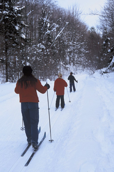
Whether you're a beginner or an expert, exciting trails await you at Valley Spur! Twenty-seven miles (45 km) of ski trails pass alongside northern hardwood forest, meadows, hemlock groves, 40-inch diameter white pine, red pine plantations, and several small lakes. Four miles of snowshoe trails offer experiences for all skill levels. The shorter, flatter, easier loop is great for beginners or a short excursion. The longer loop meanders through rolling hills and along Vally Spur Creek, presenting opportunities for off-trail explorations and solitude. Both trails do incorporate some of the single-track bike trails and cross ski trails, so be sure to practice awareness of other visitors and avoid walking over the classic ski tracks. Valley Spur is located in the Lake Superior snow belt, where 200 inches of snow per season is considered normal. On weekends, you are welcomed by a wood stove heated day lodge at the trailhead with snacks and beverages and a heated outhouse.
View and download the Valley Spur Cross Country Ski trail map before you head out.
Check out the new Valley Spur Snowshoe trail map here!
Since the 2007/2008 season, Valley Spur has been operated under a special use permit with the Noquemanon Trail Network. Fees are required. Please check the website at www.valleyspur.org for updated prices. Daily fees can be paid in the fee tubes. Memberships can be purchased in the Day Lodge.
The Valley Spur Ski Hotline (Lodge):
906-387-4918
Valley Spur Day Lodge open
Thursday- Sunday 10am – 4pm (during snow season) and some holidays.
For ski trail condition reports, visit our XC Ski page, or call the day lodge.
At a Glance
| Current Conditions: | This trail is groomed. The parking lot/traihead is plowed. |
|---|---|
| Fees: | Fees are required. Please check the website at www.valleyspur.org for updated prices. Daily fees can be paid in the fee tubes. |
| Permit Info: | Valley Spur has been operated under a special use permit with the Noquemanon Trail Network |
| Closest Towns: | Munising |
| Restroom: | Heated outhouse |
| Information Center: | Caution should be used when skiing these trails. Although all trails are groomed, some spots may be icy or uneven or may have twigs. Under icy conditions, skiing is not safe because it becomes difficult to maintain control within the designed limits of the trail. Be aware of changing weather conditions and personal fatigue which can increase the hazards of the out-of-doors. Use the "buddy system" to make your outing safer and more enjoyable. Ski only to your ability. |
General Information
Directions:From the intersection of M-28 and M-94 just south of Munising drive southwest 4 miles on M-94 to the trailhead on the left side of M-94. Facilities include a parking area, trail head map and display, toilet and drinking water.
Activities
Day Hiking
Hikers can utilize the 26 miles of biking routes as well as the 11 cross country ski trail loops. This versatility allows the day hiker many different hiking opportunities from short and easy to longer and more adventurous. Please consult the Valley Spur Biking map or the Valley Spur Cross Country Ski Trail map for more information.
| Difficulty Level: | Easy |
|---|
XC Skiing/Snowshoeing
Twelve loop trails are well-marked with black letters on blue trail markers. Trails segments start at the day lodge and are marked at each trail junction. Location maps are posted at all trail intersections. Loops are identified by letter. (Distances are measured as round trips from the lodge.) All trails are groomed for classic skiing as well as skate skiing.
Trail A (1mi/1.6 km) - Gentle terrain with a few moderate slopes, appropriate for beginners or for a warm-up.
Trail B (2.8 mi/4.5 km) - Designed as a long scenic trail for the beginning skier. Terrain ranges from the long, straight "Locomotive Chase" that runs beside the Valley spur Creek, to long, gentle downhill slopes.
Trail C (1.8 mi/2.9 km) - A short route designed for the intermediate skier. "Whoop-de-doo," a quick dip in the course, offers an experience befitting of the name.
Trail D (1.6 mi/2.6 km) - A short trail for the intermediate with an uphill stretch, "Stairway to Heaven," leading to the long, smooth downhill "Heaven."
Trail E (2.6 mi/4.2 km) - The expert or more experienced skier will meet the challenge of the steep "Boomer" downhill.
Trail F (3.7mi/6 km) - Designed for the more experienced skier, this segment offers a quarter-mile downhill run, "Bigfoot's Revenge," and a gradual, scenic uphill.
Trail G (6.2 mi/10 km) - The most challenging of the Valley Spur loops, Segment G offers a downhill run, "Catapult Hill," "Slingshot" and other highlights.
Trail H (4.4 mi/7 km) - A challenging course designed for the intermediate skier that travel among many old growth hemlock.
Trails W (4.0 mi/ 6.0 km), Y (7 mi/11.3 km) and Z (5.2 mi/8.4 km) W, X and Y were designed with the intermediate skier in mind. Y features “Heart Attack Hill”, a long steep uphill climb. Z, being very hilly with long downhills and steep uphills, will appeal to the experts.
| Status: | Open |
|---|---|
| Difficulty Level: | Easy to Difficult |
Related Information
Highlights
- Check out videos from around the Forest
- eBikes

Please note that our biking trails are designated "non-motorized." In keeping with agency direction, non-motorized trails are not open to eBikes. - How to Live with Black Bears

- Hiawatha Tour App
Use Hiawatha's OnCell app on your personal mobile device to take self-guided tours of natural and heritage sites. - Recreation, Heritage & Wilderness Management
National Forests are managed for multiple uses. Learn how these resources contribute!
Location


