Trail #9 Round-the-Mountain


Area Status: Unknown
  

TRAIL HAZARD ALERT:

Due to heavy winter snow pack, historically unstable ice and bedrock, and warm temperatures in the forecast, there is a high probability of a large debris avalanche originating from Avalanche Glacier affecting the basins below.  Please see the map of the hazard zone.

Use caution when traveling on Round-the-Mountain Trail #9 & avoid areas upslope of the trail.

Round-the-Mountain Trail #9 is considered the upper limit of safety; however, historic debris flows have descended well below the trail.

Safety Tips:

  • Avoid camping within 1 mile of the hazard zone.  View the hazard zone here.
  • Avoid traveling upslope of Round-the-Mountain Trail #9. Use caution if traveling along the trail.
  • Observe stream flow. If it suddenly becomes muddy, increases, or decreases in flow leave the area immediately.
  • Listen for rock & ice fall. Look up periodically at Avalanche Glacier for any potential movement.


This Trail Open to Hiker and Equestrian Use.

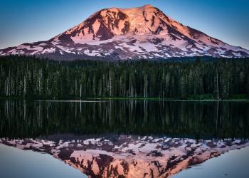
The 8.3 mile Round the Mountain Trail has numerous scenic opportunities, as it follows a generally rolling grade around the base of Mt. Adams. The slopes are splashed with color from wildflowers, amid the small subalpine fir and white bark pine. This trail connects the Pacific Crest Trail #2000 on the west side of Mt Adams with Yakama Indian Reservation Tract D area on the eastern flank of Mt Adams. 

Alert: Spring washouts can make river crossings dangerous, or impassable to stock.

From Pacific Crest National Scenic Trail #2000 near Horseshoe Meadows, the trail heads southeastward, at around 6000 feet elevation. The first trail junction is at 1.1 miles, with Looking Glass Lake Trail #9A. The trail continues for another 2.2 miles, crossing several glacier-fed meltwater streams, to the junction with Shorthorn Trail #16. The trail continues on for another 2.8 miles to the junction with the South Climb Trail #183. From here the trail follows the wilderness boundary, skirting the north end of the Aiken Lava Bed.

The trail enters the Yakama Indian Reservation at the junction with Snipes Mountain Trail #11. The Forest Service maintains the trail to the reservation boundary. The section through Bird Creek Meadows is under management of the Yakama Indian Nation. Permits to use Yakama lands are available from rangers stationed at Bird Lake. From here the trail enters Bird Creek Meadows on the Yakama Indian Reservation. The trail ends on Road 8290.285 in the reservation. 

At a Glance

Current Conditions: 11/06/2023: Trail is snow covered. For more information contact the Mt. Adams Ranger Station 509-395-3402.
Permit Info:
  • Wilderness Permit Required. Permits are free and self-issued at trailheads.
  • A seperate permit is required within Yakama Indian Reservation. Contact Yakama Nation for permits, closures, and site information.
Usage: Light-Medium
Restrictions: Wilderness Regulations apply    Building, maintaining, or using a campfire, within Mt. Adams Wilderness is prohibited:
  • Above the Round-The-Mountain Trail #9 from the Gifford Pinchot National Forest Boundary west to Pacific Crest Trail #2000;
  • Above Pacific Crest Trail #2000 north to the intersection of Highline Trail #114;
  • Above trail #114 north and east to the Gifford Pinchot Forest Boundary. (36 CFR 261.52(a) )
Closest Towns: Trout Lake, WA
Passes: A valid Recreation Pass is required at Cold Springs Campground/South Climb Trailhead. Purchase of a Mt. Adams Climbing pass is required if you are climbing above 7,000 feet elevation in Mt. Adams Wilderness, between May 1 and September 30. Climbing Passes are available online only at www.recreation.gov/sitepass/74420    
Operated By: Forest Service
Information Center: Mt. Adams Ranger District

General Information

Directions:

Trail can be accessed from Trails #2000, #183, #11, and #16 .


Activities

Day Hiking

See activity description under Backpacking.

Backpacking

The general route has been used by Native Americans since at least the 1840s to access huckleberry patches on the north and west sides of the mountain. C.E. Rusk, his mother, and his 12-year-old sister were reportedly the first non-Native Americans to make a circuit of the mountain in 1890, using Native American trails that follow the same general route as the current trail. Beginning from the Pacific Crest National Scenic Trail #2000 near Horseshoe Meadows, the trail heads southeastward, at around 6000 feet elevation. The first trail junction is at 1.1 miles, with Looking Glass Lake Trail #9A. The trail continues for another 2.2 miles, crossing several glacier-fed meltwater streams, to the junction with Shorthorn Trail #16. The trail continues on for another 2.8 miles to the junction with the South Climb Trail #183. From here the trail follows the wilderness boundary, skirting the north end of the Aiken Lava Bed. The trail enters the Yakama Indian Reservation at the junction with Trail #11. The Forest Service maintains the trail to the reservation boundary. The section through Bird Creek Meadows is under management of the Yakama Indian Nation. Permits to use Yakama lands are available from rangers stationed at Bird Lake. From here the trail enters Bird Creek Meadows on the Yakama Indian Reservation. The trail ends on Road 8290.285 in the reservation. You can extend your trip by using a section of the Pacific Crest National Scenic Trail #2000 from Horseshoe Meadows to the north. From here, head east and then south again on Highline Trail #114. In order to completely circle the mountain, you will need to negotiate a 4.5-mile section between Avalanche Valley and Bird Creek Meadows where there is no trail connection. This is difficult terrain to cross, with a number of extremely difficult stream crossings. Features include numerous crystal clear streams and up-close views of Mt. Adams. The trail also offers views of the massive debris avalanche that occurred in 1997, beginning in the Avalanche Glacier cirque, at the 12,000 feet elevation on the southwestern flank of Mt. Adams.

Horse Riding

See activity description under Backpacking.

Viewing Wildlife

Viewing Plants

Wildflowers

Viewing Scenery

Mt Adams

Related Information

Recreation Areas

Recreation Activities

Location

 
  Area/Length : 
8.3 miles

  Elevation : 
6000' - 6400'