
Official websites use .gov
A .gov
website belongs to an official government organization in the
United States.
Secure .gov websites use HTTPS
A lock
(
) or https:// means you've safely
connected to the .gov website. Share sensitive information only
on official, secure websites.


Noon Creek Campground and Picnic Area
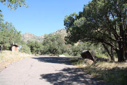
The name Noon Creek (Map) comes from the fact that when pioneer settlers traveled this way on excursions into the Pinaleño Mountains, this was usually as far as they were able to get via horse and wagon by lunch time of the first day. Noon Creek thus became a traditional lunch stop along the historic travel route into the Pinaleños and it remains a popular spot today. The surroundings here are typical of mountain oak woodlands with junipers and scrub oaks standing as the tallest trees, while satin barked manzanita, saw-leafed sotol, and soaptree yucca form a picturesque understory. As you enjoy your favorite picnic dish in this setting, keep an eye out for some of the local residents. You may catch a glimpse of a spiny lizard or a raspy-voiced cactus wren, a bird well adapted to life in this dry, bristling environment. Watch for roadrunners as they dart among the underbrush always on the lookout for a slithery meal.
Notes:
- Black bear area. Store and dispose of all food in bear-proof containers and trash bins, or keep it locked in your vehicle.
- Poison Ivy in the area
Noon Creek Campgound has public corrals.
The Noon Creek #302A trail starts at the campground at connects to Round the Mountain #302. The Ladybug #329 trail starts across the road near Angle Orchard.
At a Glance
| Reservations: | This is a first-come, first-served campground. Reservations are not accepted. |
|---|---|
| Area Amenities: | Tent camping, Fee charged for some activities, Picnic tables, Toilets, Parking |
| Fees: | Single site: $15. With Golden Age/Access or Interagency Senior/Access pass $7.50. Double site: $30. Payable with cash or check. |
| Open Season: | Year-round |
| Usage: | Light |
| Restrictions: | Tent Camping Only. Maximum of 10 people and 2 vehicles per site. Pack and saddle stock are not permitted in the campground. |
| Closest Towns: | Safford, AZ |
| Information Center: | Safford Ranger District Phone (928) 428-4150 |
General Information
Directions:From Safford, Arizona: Take US 191 south for 6 miles. Turn right onto AZ 366/Swift Trail and travel approximately 7 miles. The campground is on the right side of the road.
From Tucson, Arizona: Take I-10 east for 90 miles. Take exit 352 for US 191, and turn left toward Safford. Drive 26.3 miles north and turn left on AZ 366/Swift Trail. Drive approximately 7 miles. The campground is on the right side of the road.
Activities
Campground Camping
Picnicking
| No. of Sites | 15 |
Amenities
| Picnic tables: | Yes |
|---|---|
| Tent camping: | Yes |
| Fee charged for some activities: | Yes |
| Parking: | Yes |
| Toilets: | Yes |