
Geology
Nestled in the heart of western Wyoming, the Bridger-Teton National Forest spans 3.4 million acres of dramatic and diverse geology. Home to portions of the Wind River Range, including Gannett Peak—Wyoming's highest summit at 13,804 feet—the Forest also encompasses the Teton, Gros Ventre, Wyoming, Salt River, Hoback, and Snake River Ranges. Shaped over millions of years by powerful forces like earthquakes, flowing glaciers, and ancient volcanoes, you can explore the geology of the Bridger-Teton by hiking and climbing its tall peaks, rafting a canyon, or taking a drive through one of the many valleys. See ancient fossils, soak in a hot spring and visit areas where large landslides once occurred.
Commemorating 100 Years of the Gros Ventre Landslide
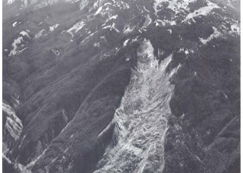
The Gros Ventre Slide Geological Area was designated by the Forest Service in 1962 to preserve and commemorate the 1925 Gros Ventre landslide. It serves as a reminder that geology is always changing, sometimes slowly, and sometimes in the blink of an eye.
Glacier Monitoring

The Greater Yellowstone Ecosystem (GYE) is a region that encompasses four different glacier bearing mountain ranges, including the Wind River, Teton Range, Absaroka and Beartooth ranges, and extends into both Montana and Wyoming.
Periodic Spring

Situated at the base of limestone cliffs, Periodic Spring discharges about 285 gallons per second. Spring water gushes from an opening for several minutes, stops abruptly, then begins a new cycle a short time later. Intermittent water flows range anywhere from four to 25 minutes and the water is clear and cold.
This is a very rare type of spring with only a few known in the world. Unlike thermal geysers, where water is heated and pressurized, the spring has disputed theories as to its perplexing behavior. One theory suggests siphoning action. Water fills a subsurface reservoir and flows freely from the opening until the water level drops below the siphon intake. The reservoir then refills and the process starts all over.
Fluvial Activity
The Parting of the Waters National Landmark
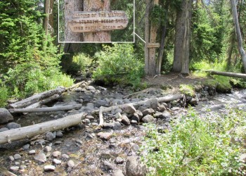
Directions: This landmark is in the Teton Wilderness 50 miles northeast of Jackson, WY and about 7 miles south of the Yellowstone National Park border. Site is accessible by a 15-mile hike from the Pacific Creek Trailhead (off Highway 89, just north of Moran Junction, at the end of Pacific Creek Road) or from the Turpin Meadow trailhead (on Forest Service Road 30050 east of Moran Junction).
Description: Two Ocean Creek parts ways on the continental divide with one branch, Atlantic Creek, flowing east, and the other, Pacific Creek, flowing west. This point can claim to be part of the headwaters of both the Missouri and Columbia River systems. Origins of the Snake, Yellowstone, Colorado, and Green Rivers can also be traced to other regions within the Bridger-Teton National Forest.