
Pinyon Plain Mine (formerly Canyon Uranium Mine)
The Pinyon Plain Mine (formerly Canyon Uranium Mine), is a uranium mine located 6 miles southeast of the Town of Tusayan on the Tusayan Ranger District of the Kaibab National Forest and operated by Energy Fuels Resources (EFR). The entire mine site is about 17 acres in size.
Current Status
The mine is in production. Energy Fuels Resources resumed ore hauling on February 12, 2025. This followed several months of discussions between Energy Fuels and the Navajo Nation related to ore transportation across Navajo Nation lands. Energy Fuels voluntarily paused ore transportation after two shipments on July 30, 2024 to allow for the discussions with the Navajo Nation. The Forest Service was not a part of these discussions
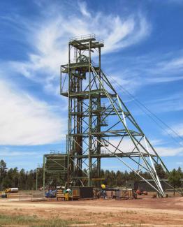
Pinyon Plain Mine
Photo Credit: USDA FSOn January 8, 2024, Energy Fuels Resources notified the Kaibab National Forest that uranium ore was removed from Pinyon Plain Mine and placed on the ore pad. This is the first time that ore has been removed from the mine. Energy Fuels cites the current high price of uranium as the reason for beginning ore production.
The mine is within the Baaj Nwaavjo I’tah Kukveni – Ancestral Footprints of the Grand Canyon National Monument. This monument was designated by Presidential Proclamation on August 8, 2023. Although this designation withdrawals the area from future mineral entry, Pinyon Plain Mine is not affected because it is a valid existing right.
In December 2022, Energy Fuels began preparatory operations – removing waste rock and other activities associated with connecting the existing mine shaft to the ore body, construction of a lined ore pad, and construction of a ventilation shaft – in anticipation of ore removal. In 2018, Energy Fuels completed sinking the mine shaft, which extends to a depth of approximately 1,470 feet.
The U.S. Geological Survey (USGS) has drilled a monitoring well just outside the fenced area of Plain Mine. The monitoring well is intended to provide further information concerning perched aquifers in the Pinyon Plain Mine area and also for perched aquifers in general to inform monitoring of the Northern Arizona Withdrawal. USGS is also conducting regular monitoring of soils, water, plants, and wildlife in and around the mine. More information about USGS’s monitoring and research efforts can be found on their website. Monitoring data include chemistry of the on-site containment pond, which are available for 2017, 2018, 2019, 2020, 2021, 2022, and 2023-2024.
On June 25, 2012, the Forest Service entered into consultation with tribes under 36 CFR 800.13 (b)(3), the Post-Review Discovery Process, and concluded that consultation in December 2015. The Forest Service remains committed to working with tribes, the Arizona State Historic Preservation Office and the Advisory Council on Historic Preservation throughout the life of the mine in keeping with the 1986 Record of Decision and the existing Plan of Operations for the mine.
Uranium
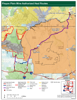
Travel route of ore from Pinyon Plain Mine to the White Mill Mesa near Blanding, Utah.
There are approximately 1,629,000 lbs. of U3O8 at Pinyon Plain Mine, contained in 82,800 tons of inferred resource at an average grade of 0.98% U3O8. In northern Arizona, uranium deposits are located in breccia pipes, which are vertical cylindrical bodies of broken sedimentary rock. Over the past half century, there has been intense interest in these uranium resources. Uranium is managed as a locatable mineral on federal land including National Forests. Locatable mineral policy and additional information is available on Forest Service Minerals and Geology Management website.
Ore Transportation
Ore is hauled by truck to the White Mesa Mill near Blanding, Utah. Two potential haul routes are currently identified. Both routes begin on Forest Service roads 305/305A/305AB, which lead from the mine to State Route 64. From there, the company has indicated that long-term it plans to use a route that consists of State Route 64 and US Highways 180, 89, 160, and 191 to access the mill. However, a portion of this route passes through State and private lands that require additional permissions. Until Energy Fuels obtains these permissions, the haul route will follow State Route 64 further south to I-40 at Williams then to US 89 through Flagstaff. Both routes pass through the Navajo Nation.
Ore transportation is not regulated by the Forest Service. Instead, it must adhere to U.S. Department of Transportation regulations at Title 49 of the Code of Federal Regulations. Energy Fuels and their hauling contractor have developed the following plans to ensure adherence to these regulations and describe the protocol for emergency response to incidents related ore haulage.
- Energy Fuels Transportation Policy for Shipments of Uranium Ores to the White Mesa Uranium Mill
- Transportation Emergency Response Plan for Shipments of Uranium Ore from Pinyon Plain Mine to the White Mesa Mill
The Kaibab National Forest’s roles related to Pinyon Plain Mine are to 1) ensure compliance with the existing Plan of Operations and the federal decision in the environmental review documentation; 2) provide current, accurate and timely information about operations at the mine to interested and concerned parties; 3) work with other agencies to inform monitoring; and 4) ensure surface reclamation is conducted in alignment with all regulations and bonding once mining operations are completed. Information about other agencies’ roles in regulating the mine can be found in the “Additional Links” section below. Summaries of the Forest Service’s recent monitoring of mine operations are available here.
In addition to being within the Baaj Nwaavjo I’tah Kukveni – Ancestral Footprints of the Grand Canyon National Monument, Pinyon Plain Mine is located within the area segregated in 2009 and then ultimately withdrawn for 20 years in the Northern Arizona Withdrawal process by the Secretary of Interior on January 9, 2012. Mining claims at the Pinyon Plain Mine were evaluated by Forest Service mineral examiners with regard to valid existing rights under the 1872 Mining Law. This Mineral Validity Examination (below), completed on April 18, 2012, confirmed the existence of valid existing rights.
Excerpt from "Mineral Report" for Lode Mining Claims, Kaibab National Forest, Canyon 74-75 Mining Claims
Summary, Conclusions and Recommendations
This report documents the results of a validity examination of two unpatented lode mining claims known as the Canyon 74 and 75 claims, located within the Tusayan Ranger District, Kaibab National Forest. The area containing the claim block is within the Northern Arizona Mineral Withdrawal that was segregated from the Mining Law for two years by Secretary of Interior, Salazar, on July 21, 2009, for approximately 1-million-acres surrounding the Grand Canyon National Park region, including BLM and FS lands. By Secretarial order on January 9, 2012, the entire 1-million-acre area that was under consideration for withdrawal was withdrawn for a period of 20 years by the Secretary of Interior.
It is Forest Service policy (FSM 2803.5) to only allow operations on mining claims within a withdrawal that have valid existing rights (VER). Certified mineral examiners: Michael Linden and Mike Doran conducted the validity exam, which was prompted by a request to resume development and mining operations at Denison’s Canyon Mine, within the Canyon mining claim block.
Over the course of several months this past fall and winter (2011), field visits were made by the examiners to the Canyon claims, the core shed at the Canyon Mine, Denison’s offices in Fredonia, Arizona, Denison’s Arizona One uranium mine on the BLM Arizona strip, and Denison’s White Mesa Mill in Blanding, Utah.
The Canyon 74 and 75 claims overlie a breccia pipe uranium deposit, which has been called the Canyon Pipe. Drilling by various uranium companies over the years has confirmed the presence of a breccia pipe that contains approximately 84,207 tons of uranium ore grading at 0.97% U3O8. This equates to roughly 1,633,345 pounds of uranium oxide.
We conclude that a discovery of a valuable mineral deposit existed at the time of the segregated withdrawal on July 21, 2009, within the limits of lode claims; Canyon 74 and Canyon 75, as required under the 1872 Mining law (30 USC 21-54). Furthermore, under present economic conditions, the uranium deposit on the claims could be mined, removed, transported, milled and marketed at a profit. We conclude that the test for discovery of a valuable mineral, as set out under Castle v. Womble, 19 LD 455 (1894) has been met, “ ...where minerals have been found and the evidence is of such a character that a person of ordinary prudence would be justified in the further expenditure of his labor and means, with a reasonable prospect of success, in developing a valuable mine, the requirements of the statute have been met”. The Canyon 74 and Canyon 75 claims have valid existing rights that were established prior to the mineral withdrawal.
In October 1984, Energy Fuels Nuclear submitted a proposed Plan of Operations to mine uranium from the Pinyon Plain Mine claims. The Forest Service completed an Environmental Impact Statement to evaluate the plan, including significant comment and input from federally recognized tribes. The final Environmental Impact Statement and Record of Decision were issued on September 29, 1986, approving the Plan of Operations with modifications. Mine site surface preparation activities began in late 1986. Appeals of this decision were made to the Southwestern Regional Forester and the Chief of the Forest Service, who both affirmed the Forest Supervisor’s decision. The Havasupai Tribe and others then sued over this decision in the U.S. District Court for the District of Arizona. The District Court ruled for the Forest Service on all counts, and a subsequent appeal was filed with the U.S. Court of Appeals for the Ninth Circuit, which affirmed the District Court on August 16, 1991.
- Canyon Mine Plan of Operations, October 1984 (4.3 MB)
- Final Environmental Impact Statement Canyon Uranium Mine, September 1986 (9.1 MB)
- Appendix, December 1985 (12.8 MB); Note: Draft EIS Appendix was included as part of the Final EIS.
- Record of Decision, Canyon Uranium Mine, September 1986 (7.8 MB)
- Decision of the Deputy Regional Forester In Response to Appeals (21 MB)
- Decision of the Chief of the US Forest Service (29.7 MB)
- US District Court, District of Arizona, Order, April 1990 (1.7 MB)
On March 10, 2021, the Forest Service accepted EFR’s clean closure plan and updated reclamation cost estimate. The clean closure plan provides the details for closure of the mine and reclamation of the site, which were described generally in the Plan of Operations. The reclamation cost estimate informed EFR’s current reclamation bond amount.
- Canyon Mine Clean Closure Plan and Reclamation Cost Update, September 2020 (4.2 MB)
Also in 2012, the Kaibab National Forest completed a review of the Pinyon Plain Mine Plan of Operations and all other associated approval documentation and determined that no modification or amendment to the existing Plan of Operations was necessary; that no correction, supplementation, or revision to the environmental document was required; and that operations at Pinyon Plain Mine could continue as a result of no further federal authorization being required. That review was completed June 25, 2012.
The Environmental Impact Statement requires baseline radiological monitoring to be conducted one year prior to ore production at Pinyon Plain Mine. Initial data collection was completed in the 1980s. Supplemental data were collected 2016-2017 and again beginning in 2023.
- Arizona Department of Environmental Quality
- Water quality permitting: www.azdeq.gov/WQD/PinyonPlainMine
- Air quality permitting: www.azdeq.gov/aqd/PinyonPlainMine
- United States Geological Survey: https://webapps.usgs.gov/uraniummine/ - (go to Studies dropdown to access page specific to Pinyon Plain Mine)
- U.S. Environmental Protection Agency: www.epa.gov/caa-permitting/canyon-underground-uranium-mine-coconino-county-arizona
- Energy Fuels Resources www.energyfuels.com/pinyon-plain-mine
To contact the Forest Service about Pinyon Plain Mine, you can email SM.FS.KaibabPAO@usda.gov.