
Casner Mountain Trail No. 8
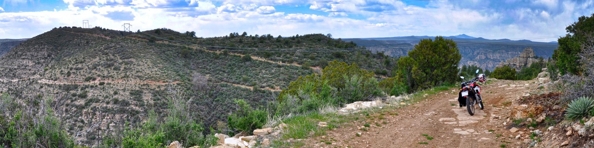
Originally built to maintain power lines, Casner Mountain Trail offers spectacular views of Sycamore Canyon Wilderness, Red Rock Secret Mountain Wilderness, and the Verde Valley. The trail follows an old jeep road which still provides access to the power lines and off-highway opportunities for motorized vehicles. Wildlife is abundant, so watch for elk and deer. An occasional bear and even mountain lion are spotted. The trail at the bottom begins in high desert vegetation and switchbacks up the side of Casner Mountain. Once on top of the mesa, pinyon/juniper with open grasslands are the norm. Take lots of water, especially during the summer months.
So, if you're looking to wind your way up or down this road/trail, beware that you're in for some breathtaking views, and you better bring your 'A' game with a high-clearance vehicle because it's not for the faint of heart. Whether you're hiking or doing some steep climbing with your vehicle, make sure to check out the General Information below for specifics.
Photo Gallery


Specific Trail Information
Trail Number
Trail Type
General Information
- Hikers and mountain bikers: The trail is open year-round, and the ascent is very strenuous and accounts for about 2 miles of the total length. However, once on top the hike/ride is really quite easy to moderate.
- Motorized vehicles: Casner Mountain Trail is designated as a motorized trail with very rugged conditions along a narrow ridge with limited opportunity for two-way traffic. Gates are closed year-round, but access can be gained by the following:
- ATVs/dirtbikes (vehicles LESS than 62" wide): No permit is required. The trail is open year-round between the intersection of Forest Roads (FR) 525 and 9529 at the bottom of the mountain, and FR 538B, where the trail enters the Flagstaff Ranger District at the top. Though there are gates at the top and bottom, there is room to go around the gates if your vehicle is less than 62 inches wide. During wintertime there can be seasonal road closures in this region of the Forest, so make sure to give the Red Rock Visitor Center a call to check on the status gates at either end of Casner Mountain Trail #8. Do not pass the upper gate onto FR 538B when the area is listed as closed for the winter—even if you have a vehicle less than 62 inches wide.
- OHVs/modified 4-wheel drive vehicles (vehicles MORE than 62" wide): A permit is required, which is free. The road is only open for permitted access between mid-May and mid-October. See the Permits dropdown menu below for details on how to obtain a free permit (by phone only).
- ATVs/dirtbikes (vehicles LESS than 62" wide): No permit is required. The trail is open year-round between the intersection of Forest Roads (FR) 525 and 9529 at the bottom of the mountain, and FR 538B, where the trail enters the Flagstaff Ranger District at the top. Though there are gates at the top and bottom, there is room to go around the gates if your vehicle is less than 62 inches wide. During wintertime there can be seasonal road closures in this region of the Forest, so make sure to give the Red Rock Visitor Center a call to check on the status gates at either end of Casner Mountain Trail #8. Do not pass the upper gate onto FR 538B when the area is listed as closed for the winter—even if you have a vehicle less than 62 inches wide.
- Casner Mt. Peak: 6,819 ft.
- Casner Mt. Trailhead TOP: 6,467 ft.
- Casner Mt. Trailhead BOTTOM: 4,655 ft.
- Length Between Top & Bottom Trailheads: 6.9 miles one way.
- Hiking Time: Plan on a full day/overnighter.
- Interactive Topo Map: Casner Mt. Trailheads #8 (Bottom) (Top)
WHAT TO DO: Call (928) 203-2912 or (575) 551-6033 to obtain a free permit, and be ready provide approximate number of people and vehicles, as well as desired date. Only telephone calls will be accepted to reserve your permit. Voicemails, emails, and texts will NOT be accepted as a way of obtaining a permit. You can direct questions to michael.gordon@usda.gov, but emails cannot be used for obtaining permits.
- March 6, 2025 at 8:30 a.m. is the starting date for reserving weeks 1-11 (May 5-July 20).
- June 5, 2025 at 8:30 a.m. is the starting date for reserving weeks 12-22 (July 21-October 5).
- Permits will be mailed. When received, it must be signed and be in your possession while traveling on the road.
- Only one group permit will be issued per calendar week during the open season, allowing for a one-day visit.
- NO CAMPING OR CAMPFIRES allowed between the gates.
- No less than 3 vehicles, no more than 10 vehicles and groups smaller than 25. Permit holders may be asked to combine groups.
- This is a motorized, multi-use trail open year-round to hikers, mountain bikers, and motorized vehicles less than 62" wide. For OHVs and modified 4-wheel drive vehicles greater than 62" wide, the trail is only open mid-May to mid-October by permit.
- BEWARE! This trail requires (at a minimum) 4-wheel drive capability and high-clearance due to its challenging terrain and steep gradients.
Getting There
Parking
There is limited parking at the hiking trailheads, so please park on the side of the road and do not block the road.
Directions
Location: About 48 miles south of Flagstaff (17 miles west of Sedona) on paved and graveled roads.
Access:
- From Flagstaff via Sedona: Drive 30 miles south from Flagstaff through Sedona on U.S. Highway 89A. Five miles past Sedona turn north on Forest Road (FR) 525 and follow the signs to Sycamore Pass. Turn west on FR 525C and continue on FR 525C for 7.2 miles to the hiking trailhead on your right. Motorized vehicle access: From the hiking trailhead, continue up FR 525C for another 0.3 mile and turn right on FR 9529. Continue up FR 9529 under the powerlines for approximately 0.5 miles to a yellow gate.
- From Flagstaff via Woody Mountain Road: Take Woody Mountain Road which turns into FR231 for about 14 miles to FR 538. Turn right on FR 538 and drive 1 mile where it turns into FR 527 on your left. Continue on FR 527 about 1/3rd of a mile and keep left where it turns back into FR 538. Travel on FR 538 for about 4 miles to the intersection of FR 538 and FR 538E. Turn left on FR 538 at that intersection and travel 3.8 miles on FR 538 to the intersection of FR 538B. Turn right on FR 538B and travel about 3.16 miles to the gate (the last mile is rough and a high-clearance vehicle is required). If you are hiking, please park in the nearby parking area just before the gate and do not block the road. If your vehicle cannot make the last mile, park on the side of the road where you feel comfortable and hike the rest of the way.
GPS:
- South Trailhead (via Sedona) (Map): 34°55'07.8"N 111°58'44.5"W
- North Trailhead (via Woody Mountain Road) (Map): 34°59'09.8"N 111°56'46.1"W
Digital Travel Map
The Digital Travel Map Whether you're driving, hiking, riding, or exploring, you will find this full-color, GPS-enabled map a handy reference to have on your mobile device. The map show trails, recreation sites, major landmarks, and forest roads.
Additional Information
Operated By
Red Rock Ranger District: 928-203-2900