

Recreation
Bitterroot National Forest Trail Clearing Status Map

Use this map tool to view and search what trails and when those trails were cleared of down trees on Bitterroot National Forest trails.

Bass Creek Recreation Area offers wilderness trail access, campgrounds for families and groups, equestrian facilities, and multi‑use trails for hiking and biking.

Discover the Darby Ranger District—your gateway to the southern Bitterroot Valley’s most iconic landscapes. From the sweeping Sapphire Divide to the rugged canyons of the Bitterroot Range and the vast Selway‑Bitterroot Wilderness, this district offers premier access to some of Montana’s most spectacular terrain.
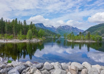
Lake Como Recreation Area provides a classic Bitterroot National Forest experience, offering opportunities for swimming, fishing, boating, hiking, mountain biking, horseback riding, and camping in a scenic mountain valley.

According to early accounts, Lost Horse Creek earned its name in 1881, when prospectors attempted to cross its swift spring runoff and one of their horses was swept away. The story spread, and the creek soon became known as “Lost Horse”—a name that has endured for generations.

The Magruder Corridor offers a rare chance to explore one of the most remote and undeveloped landscapes in the lower 48. This 95‑mile primitive road winds between the Bitterroot National Forest and the Nez Perce–Clearwater National Forests, showcasing sweeping views of the Bitterroot and Clearwater ranges and providing access to a landscape that remains much as it was for early travelers.

Discover the Stevensville Ranger District, located in Montana’s first permanent settlement and the northernmost reach of the Bitterroot National Forest. This district features the rolling Sapphire Mountains to the east and the rugged Bitterroot Range to the west, offering access to glacial canyons, wilderness terrain, and a variety of well-maintained trails.

Embark on your next unforgettable adventure in the Sula Ranger District—your gateway to exploration in the spectacular southeast corner of the Bitterroot National Forest. With over 250,000 acres of pristine public land—and an impressive 41,000 acres within the awe‑inspiring Anaconda-Pintler Wilderness—you’ll find endless opportunities to discover, wander, and be inspired.

Discover the West Fork Ranger District, where you can enjoy a rare chance to drive between two vast and distinct wilderness areas. This scenic corridor sits between the legendary Selway‑Bitterroot Wilderness to the north and the Frank Church–River of No Return Wilderness to the south—together forming one of the largest wilderness landscapes in the lower 48.

The Continental Divide National Scenic Trail in the Bitterroot National Forest invites adventurers to explore 25 miles of high-elevation beauty along the rugged spine of th

The Bitterroot Valley played a major role in the Lewis and Clark Expedition (1804-1806), and it is one of the most meaningful stretches of their journey west.

Experience the powerful story of the 1877 Nez Perce flight as you travel the Nez Perce National Historic Trail through the breathtaking Bitterroot Valley.
Recreation
Alta Campground
Explore Alta Campground in Bitterroot NF: RV/tent sites, river fishing, potable water, vault toilets, host site & shaded spots near hiking & hot springs.
Alta Pine Interpretive Site
This interpretive site focuses on the Alta Pine which was thought to be the second oldest pine in the state of Montana at over 800 years old. In 1989 a lightning strike damaged the tree and it was…
Andrews Creek Trail # 178
The Andrews Creek trail is a ridgeline trail approximately two miles long. It begins at the Andrews Creek trailhead and ends at Warm Springs Ridge Trail #177. This trail provides access into the Warm…
Applebury Boating Site
This site is an undeveloped boat launch site on the West Fork of the Bitterroot River. Parking is located a couple hundred feet from the site.
Bad Luck Creek Trail # 93
The Bad Luck Creek trail is 8.5 miles long. It begins at Trail 4 and ends at Trail 710. The trail is open for the following uses: Backpacking, Horseback Riding
Bad Luck Ridge Trail # 52
The Bad Luck Ridge trail is 8.5 miles long. It begins at Road 6223 and ends at Trail 710. The trail is open for the following uses: Backpacking, Horseback Riding
Bailey Lake Trail # 293
Bailey Lake Trail #293 begins at a roadside pullout located 19 miles up Lost Horse Road (Forest Service Road #429), just past the Lost Horse Guard Station. The trail is 1 mile long and begins at an…
Baker Lake Trail #234
Escape to the high country on Baker Lake Trail! This moderate 3-mile round-trip hike rewards you with sweeping views of Trapper Peak and serene alpine lakes tucked beneath rugged cliffs. Perfect for…
Baker Lake Trailhead
Site Open
Parking at Baker Lake Trailhead is limited, especially on busy, high-use days. When the main lot fills up, overflow parking typically occurs along the adjacent Forest Service road, which can become…
Bald Top Trail
The Bald Top trail is 7.5 miles long. It begins at Trail 105 and ends at Road 62726. The trail is open for the following uses: Horseback Riding, Motorcycle Trail Riding