Visitor Maps and Guides
Hiawatha National Forest Visitors Map
Digital copies of the current Forest Visitor map can be purchased through Avenza for $4.99:
Michigan Department of Transportation
Michigan Department of Transportation interactive map.
Motor Vehicle Use Maps (MVUM)
- Hiawatha NF Munising (Navigating away from USFS website)
- Hiawatha NF Rapid River (Navigating away from USFS website)
- Hiawatha NF St Ignace (Navigating away from USFS website)
- Hiawatha NF Sault Ste Marie (Navigating away from USFS website)
National Forests and National Grasslands
Guide to your National Forests and Grasslands shows all National Forests and Grasslands across the country. Forest Service District Maps
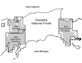
Forest and Vicinity Map
Hiawatha National Forest vicinity map for reference.
Grand Island National Recreation Area Map
Wilderness Maps
- Big Island Lake Wilderness map
Hiawatha National Forest Visitors Map
Hardcopies of the Forest Recreation map cost $14 per map. To order hardcopy maps on-line:
USGS Online Store U.S. Geological Survey Store/ Forest Service Maps
Motor Vehicle Use Maps (MVUM)
Download Motor Vehicle Usage Maps as a PDF

Download each MVUM at the links below:
Request a Print Copy
You can view these maps online, but because they are very large you may want to obtain a printed copy for field use. Copies are available at our Ranger District offices. The maps are updated annually, so remember to get a new map each autumn!
**Due to popular demand, our current stock of printed MVUMS has been depleted and they are not currently available at Ranger District Offices. The maps are being updated and reprinted, and we are awaiting their delivery. Digital copies are still available. Thank you for your patience!**
Download Mobile Motor Vehicle Use Maps
Avenza Maps® is a mobile map app that allows you to download maps for offline use on iOS or Android smartphone or tablet, use your device’s built-in GPS to track your location on any map, plot locations and photos, measure distance and area, and more. If you have the Avenza® App on your digital device, you can download the Hiawatha's MVUM maps for use on Avenza®.
- Hiawatha NF Munising (Navigating away from USFS website)
- Hiawatha NF Rapid River (Navigating away from USFS website)
- Hiawatha NF St Ignace (Navigating away from USFS website)
- Hiawatha NF Sault Ste Marie (Navigating away from USFS website)
Where Can I Ride?
You can determine where to ride a given type of motorized vehicle by consulting the Hiawatha’s Motor Vehicle Use Map (MVUM). There are three maps which together document the designated motorized use transportation system (by vehicle type and season) on the Hiawatha’s three Ranger Districts.
In addition, maps are available for the two designated OHV trails, the Coalwood Grade and the Haywire Grade OHV Trails.
Rules of the Road/Trail on the Hiawatha
- Cross country travel off the designated routes is prohibited. For example, on National Forest Land, you may not ride cross country to retrieve your deer. (This has been policy since 1986.)
- Coalwood and Haywire OHV Trails are dedicated to OHV use.
- The Motorized Vehicle Use Maps guide which roads you may use. The maps delineate use by motorized vehicle type, including seasonal restrictions. For instance, some motorized routes are open to all motorized vehicle and some are open only to automobiles.
- Travel on County roads is guided by County ordinance.
- OHVs must travel single file on the edge of the travel way, but NOT in the ditch.
- Maximum speed for OHVs is 25 miles per hour.
- East Zone OHV Routes Map - available through Chippewa Sportsmen's Off Road Vehicle Association
- West Zone of the Hiawatha Off-Road Vehicle (ORV) Map - This map shows the Marquette – Manistique Trail/Route and a selection of Forest and County Roads open to ORV use on the West Zone of the Hiawatha National Forest.
Other Maps
North Country National Scenic Trail - available through North Country Trail Association
Eastern Region national forests are making available GIS Data so that you may build your own specialty maps. To download data visit FSGeodataClearinghouse. Visit our GeoSpatial Data Page.
Michigan DNR snowmobile maps
Blueberry production usually increases dramatically within a couple years following prescribed fire, so blueberry picking enthusiasts may wish to visit these areas when searching for new picking spots.


