

Idaho Roadless Rule Corrections and Modifications
Caribou-Targhee National Forest 2015 ModificationFederal Register - Proposed Idaho Roadless Area Boundary Modification; Caribou-Targhee National Forest - (pdf - 200k)West Mink Roadless Area Map - (pdf - 848k)Gibson Jack Project Map - (pdf - 1.34mb)Idaho Panhandle National Forest 2014 Modifications and CorrectionsIdaho Panhandle Modified Roadless Areas Map - (pdf - 935k)Federal Register -…
#RoadlessRule, #Roads, #RulesAndRegulations, #Maps, #Idaho
More than a road
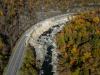
As Hurricane Helene devastated the Southern Appalachians, it brought a deluge of water that destroyed hundreds of miles of roads, from winding mountain roads all the way to interstate highways.
Aerial view of rockslide damage to I-40 post Hurricane Helene. (Courtesy photo by Andy Ryan)
When…
#Hurricane, #HurricaneDamage, #HurricaneRecovery, #Infrastructure, #Roads
Roadless Areas - Archive
2001 Roadless Rule EIS Documents2001 Roadless Rule Final Environmental Impact Statement – Vol. 1 (PDF, 16.26 MB)2001 Roadless Rule Final Environmental Impact Statement – Vol. 2 (PDF, 84.99 MB)2001 Roadless Rule Final Environmental Impact Statement – Vol. 3 (PDF, 1.26 MB)2001 Roadless Rule Final Environmental Impact Statement – Vol. 4 (PDF, 18.30 MB)2001 Roadless Rule Final Environmental Impact…
#RoadlessRule, #Roads, #RulesAndRegulations, #Alaska
Roadless Rule Metadata - Outer National Forest Boundaries Alaska Region (R10)
nfsbnd_ak_dd (coverage name)Metadata:Identification_Information:Citation:Citation_Information:Originator: USDA Forest Service - Geospatial Service and Technology Center (GSTC)Publication_Date: 20000915Title: Outer administrative boundary forUSDA Forest Service Alaska Region (R10)Edition: FinalGeospatial_Data_Presentation_Form: ArcInfo exportPublication_Information:Publication_Place: Salt…
#RoadlessRule, #Roads, #RulesAndRegulations, #Maps, #Conservation, #Alaska
2001 Roadless Rule Metadata - National Forest Boundaries Alaska Region (R10)
nfsland_ak_dd (coverage name)Metadata:Identification_Information:Citation:Citation_Information:Originator: USDA Forest Service - Geospatial Service and Technology Center (GSTC)Publication_Date: 20000915Title: NFS boundary for USDA Forest Service Alaska Region (R10)Edition: FinalGeospatial_Data_Presentation_Form: ArcInfo exportPublication_Information:Publication_Place: Salt Lake City,…
#RoadlessRule, #Roads, #RulesAndRegulations, #Maps, #Conservation, #Alaska
Roadless Areas Inventoried by State
To view Inventoried Roadless Areas by State, select a State from the list below. Please note that not all states have National Forests or Grasslands. National Forest and Grassland Maps are available from the State Maps.These maps contain areas that have been roaded.AlabamaAlabama Inventoried Roadless AreasAcreages:National Forest System Lands: 665,000Inventoried Roadless Areas: 13,000State…