Extreme drought and pine beetle outbreaks are of increasing concern for forests in the south to the extent that USDA approved financial and technical assistance to help owners restore forests on non-industrial private forestlands in Mississippi and Louisiana. Behind much of the information about the drought and the trees adversely affected are Forest Service scientists who have developed tools that allow users to see real-time effects of the drought.
Droughts occur when precipitation is unusually low, but trees are especially at risk when temperatures are extraordinarily high. When high heat develops quickly, meteorologists refer to these events as flash droughts. One such drought hit the record books in Mississippi and Louisiana in 2023, emerging in late summer as the rains diminished, but it was the extreme heat that shattered records.
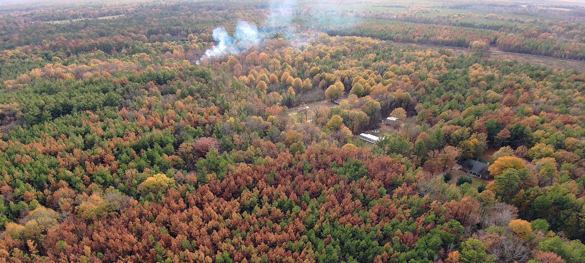
The consequences for the region’s forests were stunning. Between October 2023 and January 2024, millions of dead pine trees were noticeable across southwest Mississippi and eastern Louisiana. The deaths were exacerbated by a combination of extreme stress from hot drought and several species of pine engraver beetles called Ips that thrive under those conditions.
The widespread tree mortality affects all landowners – from urban homeowners in Jackson, Mississippi, and Alexandria, Louisiana, to industrial forest owners. These dead trees quickly became a hazard, especially in urban areas and near infrastructure like power lines. If left standing, those same trees could become matchsticks, increasing wildfire risk to the area.
The December estimate was that well over 12 million trees had died, and by late January, the count was 50% more than initially calculated.
The technology used to come up with this estimate reflects years of dedicated work.
In mid-December, my colleague Bill Christie, a biological science information specialist, and I got a call from Chris Asaro, the Forest Service program manager for Forest Health Monitoring in the agency’s Southern Region. Chris knew what we were up against.
Christie and I are the primary developers of HiForm, a state-of-the-art tool still in the advanced development stages that uses satellite data and cloud computing to reveal forest disturbances across landscapes at high resolution – insect outbreaks, wildfires, tornadoes, and more. This tool looks at change over time, usually by comparing conditions from a full year earlier to those seen today. The challenge was isolating dead and dying pine from all the other changes that occur in this busy landscape.
Immediately after Asaro’s call, we refined our HiForm workflow to isolate recently dead pines from earlier timber harvest activity and the seasonal leaf-fall of hardwoods. We then shared these products with federal and state forestry agencies.
Having a map of pine mortality that covers the entire landscape is essential for understanding the extent and potential long-term effects of this extreme event.
“We shared the risk maps with our state legislature in support of other state agencies like the Mississippi Department of Transportation and the Mississippi Department of Emergency Management,” said Sean Hodges of the Mississippi Forestry Commission.
The event may be the worst thing to happen to the forests of southwest Mississippi in a very long time. We don’t know because record keeping for unusual events like this was poor in the past. While we map southern pine beetle spots reasonably well, the pine engraver beetle activity and associated drought mortality is more dispersed and normally much less extensive.
The population of pine engravers increases when trees are stressed by drought or other disturbances like hurricanes. Still, pine engravers usually kill few trees, and their behavior is much less well understood than that of the southern pine beetle, which gets most of the attention. Pine engravers only become a major problem when trees are stressed over large areas, and this recent drought was the hottest late-season drought seen since record-keeping began in 1895.
Since 2016, HiForm has mapped disturbances using change in a vegetation-sensitive measure called the Normalized Difference Vegetation Index. The team calculates seasonal indexes at 10-meter, or 32-foot - resolution from the European Space Agency’s Sentinel-2 satellite sensors, which produce new imagery every five days.
Rapidly evolving technologies like HiForm are revolutionizing the way we monitor forest changes. These technologies let us track forest health throughout the year and capture sudden disturbances in near-real-time.
This effort provided our best opportunity yet to demonstrate to our regional and state partners how valuable, effective, and efficient remote sensing technology can be. These tools help improve how we map forest disturbances, including those that are more extreme and sudden than unexpected. The information also allows officials to make quicker decisions on the ground.
For example, we shared our first estimate about drought beetle mortality with the Mississippi Forestry Commission and with Louisiana officials. In February, legislation was introduced and then approved in March that directed USDA to use all available programs to help landowners.
In April 16, U.S. Secretary of Agriculture Tom Vilsack approved the Emergency Forest Restoration Program to owners of nonindustrial forestland affected by the drought all counties in Mississippi and in May to 64 Louisiana parishes. The deadline to apply in Mississippi is Aug. 15; the deadline in Louisiana is July 12. For more information about drought and assistance, go to Farmers.gov.
Steve Norman is a research ecologist who focuses on forest monitoring, which is critical for maintaining forest resilience over the long term. His research seeks to improve the way we map forest conditions through better use of remote sensing technologies.
More information about HiForm is available online or contact Steve Norman.


