Official websites use .gov
A .gov
website belongs to an official government organization in the
United States.
Secure .gov websites use HTTPS
A lock
(
) or https:// means you've safely
connected to the .gov website. Share sensitive information only
on official, secure websites.


Selected Fires from 2006
Threat of Deforested Conditions in CA National Forests
| Overview | Deforested Condition Trends | Reforestation Trends |
| Glossary | Methods | Grouping Logic | Veg Maps |
Selected Fires: Explanatory Notes | 2000 | 2001 | 2002 | 2003 | 2004 | 2005 |
2006 | 2007 | 2008 | 2009 | 2010 | 2011 | 2012 | 2013 | 2014 | 2015 | 2016 |
Selected Wildfires
Each selected wildfire analyzed burned more than 1,000 acres of forestland (land that grows trees) on national forest in California. For each fire there is a summary table of the vegetation conditions; an image of the fire overlaid on a quadrangle map with the image highlighting the fire boundary and burned areas that are non forest, forested and deforested; and a pdf of the fire for download which also provides a clearer view of the fire.
Summary of All 2006 Fires Combined
| Selection | Incident Name | Forest(s) | Incident Acres | Notes |
|---|---|---|---|---|
| selected A | Day | Los Padres | 161,816 | |
| selected A | Bake-Over (Bar Complex) | Shasta-Trinity | 65,048 | |
| selected A | Pigeon (Bar Complex) | Shasta-Trinity | 35,090 | |
| selected B | Hancock | Klamath | 21,866 | |
| not sel | Horse | Cleveland | 16,678 | |
| selected A | Hunter | Mendocino | 16,234 | |
| selected B | Somes | Six Rivers | 15,506 | |
| not sel | Perkins | Los Padres | 13,392 | |
| not sel | Millard | San Bernardino | 10,451 | |
| not sel | Esperanza | San Bernardino | 8,517 | |
| selected A | Ralston | Tahoe, Eldorado | 8,421 | |
| not sel | Sawmill | Inyo | 6,144 | |
| selected A | Titus (Happy Camp Complex) | Klamath | 6,076 | |
| selected B | Rush | Six Rivers | 4,872 | |
| not sel | Tamarack WFU | Sequoia | 4,656 | |
| not sel | Bald (San Rafael Complex) | Los Padres | 4,322 | |
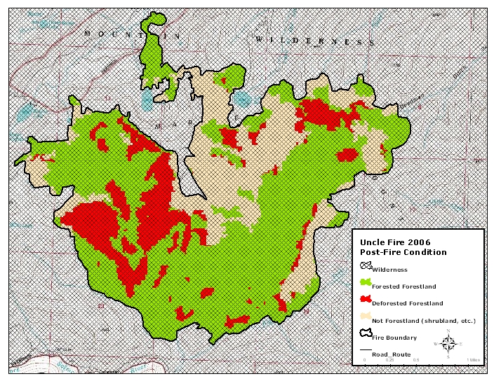
| selected B | Uncles | Klamath | 3,833 | 90th percentile |
| not sel | Sage | Modoc | 3,778 | |
| not sel | Broder / Beck WFU | 3,492 | ||
| selected A | Boulder (Boulder Complex) | Plumas | 2,919 | |
| not sel | Hotlum | 2,515 | ||
| not sel | Pinnacles | 2,506 | ||
| not sel | Goodale | 2,483 | ||
| not sel | Maggie | 2,098 | ||
| selected A | Bassetts | Tahoe | 2,097 | |
| not sel | Sierra | 1,990 | ||
| not sel | Harvey | 1,247 | ||
| not sel | Emerald | 1,198 | ||
| not sel | High | 1,053 | 97th percentile | |
| selected B | Panther | Six Rivers | 905 |
| Code | Meaning |
|---|---|
| Selected A | Large scale fires that would potentially require large scale investments in reforestation to maintain a forest cover. |
| Selected B | Five other fires were examined and displayed out of interest in fire effects, with no expectation of reforestation needs. |
| Not Selected | Seventeen other fires that were larger than 1,000 acres were not examined or displayed here because they did not burn in forested vegetation types outside wilderness areas or they burned in pinyon and/or juniper types. |
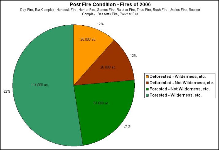
Day Fire, Bar Complex, Hancock Fire, Hunter Fire, Somes Fire, Ralston Fire, Titus Fire, Rush Fire, Uncles Fire, Boulder Complex, Bassetts Fire, Panther Fire
| vegetation type | treatments NOT permitted | treatments permitted | treatments permitted | total within fire perimeter | |||
|---|---|---|---|---|---|---|---|
| deforested condition | forested condition | deforested condition | forested condition | deforested condition | forested condition | ||
| steep ground ( > 30 % slope) |
flat ground ( < 30 % slope) |
||||||
| alpine | 223 | 637 | 0 | 17 | 0 | 9 | 886 |
| fir | 2,101 | 5,123 | 217 | 701 | 134 | 424 | 8,699 |
| pine | 2,211 | 1,806 | 1,869 | 4,225 | 4,074 | 3,308 | 17,493 |
| Douglas -fir | 5,708 | 65,365 | 1,494 | 18,224 | 815 | 4,574 | 96,182 |
| mixed conifer | 8,117 | 29,790 | 1,402 | 5,186 | 1,221 | 3,436 | 49,152 |
| closed cone conifers | 641 | 538 | 65 | 125 | 22 | 43 | 1,433 |
| coastal conifer / cypress | 0 | 0 | 0 | 0 | 0 | 0 | 0 |
| pinyon juniper | 2,206 | 902 | 3,803 | 1,666 | 9,570 | 2,233 | 20,380 |
| hardwood | 3,965 | 9,495 | 1,235 | 6,683 | 330 | 628 | 22,337 |
| sub total | 25,172 | 113,656 | 10,085 | 36,827 | 16,166 | 14,656 | 216,562 |
| shrub / non-forest | 122,607 | ||||||
| other ownership | 7,623 | ||||||
| total | 346,792 | ||||||
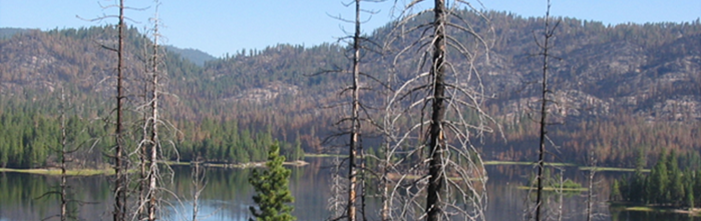
Note that almost all the acreage burned in these fires was on national forest system lands. Additionally, approximately 1/3 of the area burned is not forestland - trees don't grow there. Based upon the forestland alone, most of the burned area for these fires is in wilderness or wild and scenic river areas where reforestation work is not allowed and natural recovery must take place. Some of the approximately 50,000 acres now in a deforested condition will not recover to the same vegetation type but will convert to shrubland or perhaps grassland for the next several decades. Eventually these lands may return to a tree covered condition.
Outside of the wilderness and wild and scenic areas, approximately 26,000 acres will be considered for assisted recovery work. Assisted recovery work is any of a set of human activities that assist the natural recovery of trees. This work is done in order to restore the forest to a more natural condition as quickly as possible and to minimize the potential for invasive vegetation to move into the burned area. Treatments to the deforested areas will vary depending upon the location and the desired outcomes, but the goal of any recovery work is to quickly restore the forest's ability to provide the types of resources and values that people have come to expect from their forests. These resources and values include clean air and water, recreational opportunities, wildlife habitat, and scenic beauty; however, without reforestation, all of these values may be at risk.
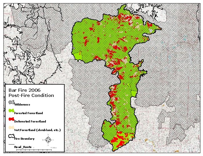
Bar Fire
| vegetation type | treatments NOT permitted | treatments permitted | treatments permitted | total within fire perimeter | |||
|---|---|---|---|---|---|---|---|
| deforested condition | forested condition | deforested condition | forested condition | deforested condition | forested condition | ||
| steep ground ( > 30 % slope) |
flat ground ( < 30 % slope) |
||||||
| alpine | 223 | 614 | 0 | 0 | 0 | 0 | 837 |
| fir types | 1,613 | 2,352 | 0 | 0 | 0 | 0 | 3,964 |
| pine types | 9 | 19 | 0 | 0 | 0 | 0 | 28 |
| Douglas -fir | 3,761 | 49,643 | 840 | 2,774 | 288 | 764 | 58,069 |
| mixed conifer types | 4,960 | 15,923 | 23 | 106 | 25 | 57 | 21,094 |
| closed cone conifers | 258 | 221 | 0 | 0 | 0 | 0 | 479 |
| coastal conifer / cypress | 0 | 0 | 0 | 0 | 0 | 0 | 0 |
| pj | 0 | 0 | 0 | 0 | 0 | 0 | 0 |
| hardwood | 1,238 | 5,674 | 782 | 1,162 | 128 | 182 | 9,166 |
| sub total | 12,062 | 74,446 | 1,646 | 4,041 | 440 | 1,003 | 93,638 |
| shrub / non-forest | 7,851 | ||||||
| other ownership | 162 | ||||||
| total | 101,652 | ||||||
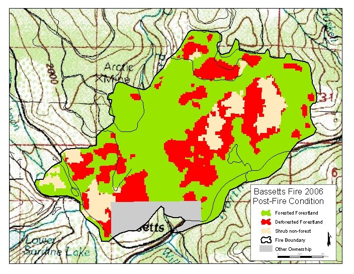
Bassetts Fire
| vegetation type | treatments NOT permitted | treatments permitted | treatments permitted | total within fire perimeter | |||
|---|---|---|---|---|---|---|---|
| deforested condition | forested condition | deforested condition | forested condition | deforested condition | forested condition | ||
| steep ground ( > 30 % slope) |
flat ground ( < 30 % slope) |
||||||
| alpine | 0 | 0 | 0 | 0 | 0 | 0 | 0 |
| fir types | 0 | 0 | 177 | 380 | 126 | 344 | 1027 |
| pine types | 0 | 0 | 0 | 0 | 0 | 0 | 0 |
| Douglas -fir | 0 | 0 | 0 | 0 | 0 | 0 | 0 |
| mixed conifer types | 0 | 0 | 184 | 300 | 147 | 446 | 1077 |
| closed cone conifers | 0 | 0 | 0 | 8 | 0 | 18 | 26 |
| coastal conifer / cypress | 0 | 0 | 0 | 0 | 0 | 0 | 0 |
| pj | 0 | 0 | 0 | 0 | 0 | 0 | 0 |
| hardwood | 0 | 0 | 0 | 0 | 0 | 30 | 30 |
| sub total | 0 | 0 | 361 | 688 | 273 | 838 | 2160 |
| shrub / non-forest | 278 | ||||||
| other ownership | 163 | ||||||
| total | 2,600 | ||||||
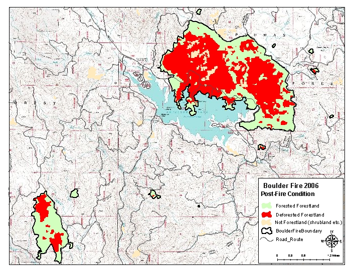
Boulder Fire
| vegetation type | treatments NOT permitted | treatments permitted | treatments permitted | total within fire perimeter | |||
|---|---|---|---|---|---|---|---|
| deforested condition | forested condition | deforested condition | forested condition | deforested condition | forested condition | ||
| steep ground ( > 30 % slope) |
flat ground ( < 30 % slope) |
||||||
| alpine | 0 | 0 | 0 | 0 | 0 | 0 | 0 |
| fir | 0 | 0 | 0 | 0 | 0 | 0 | 0 |
| pine | 0 | 0 | 187 | 28 | 419 | 251 | 885 |
| Douglas -fir | 0 | 0 | 0 | 0 | 0 | 0 | 0 |
| mixed conifer | 0 | 0 | 538 | 452 | 667 | 791 | 2,448 |
| closed cone conifers | 0 | 0 | 0 | 0 | 0 | 0 | 0 |
| coastal conifer / cypress | 0 | 0 | 0 | 0 | 0 | 0 | 0 |
| pinyon juniper | 0 | 0 | 0 | 0 | 0 | 0 | 0 |
| hardwood | 0 | 0 | 0 | 0 | 0 | 0 | 0 |
| sub total | 0 | 0 | 725 | 480 | 1,086 | 1,042 | 3,333 |
| shrub / non-forest | 148 | ||||||
| other ownership | 7 | ||||||
| total | 3,488 | ||||||
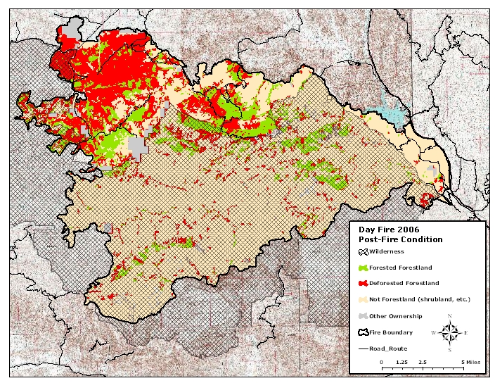
Day Fire
| vegetation type | treatments NOT permitted | treatments permitted | treatments permitted | total within fire perimeter | |||
|---|---|---|---|---|---|---|---|
| deforested condition | forested condition | deforested condition | forested condition | deforested condition | forested condition | ||
| steep ground ( > 30 % slope) |
flat ground ( < 30 % slope) |
||||||
| alpine | 0 | 0 | 0 | 0 | 0 | 0 | 0 |
| fir types | 0 | 0 | 0 | 0 | 0 | 0 | 0 |
| pine types | 2,201 | 1,771 | 1,575 | 2,237 | 3,597 | 2,633 | 14,014 |
| Douglas -fir | 1,342 | 2,211 | 38 | 165 | 5 | 16 | 3,778 |
| mixed conifer types | 1,464 | 3,412 | 198 | 891 | 175 | 239 | 6,378 |
| closed cone conifers | 363 | 308 | 0 | 0 | 0 | 0 | 671 |
| coastal conifer / cypress | 0 | 0 | 0 | 0 | 0 | 0 | 0 |
| pj | 2,206 | 902 | 3,803 | 1,666 | 9,570 | 2,233 | 20,380 |
| hardwood | 2,388 | 2,389 | 186 | 237 | 167 | 112 | 5,479 |
| sub total | 9,964 | 10,993 | 5,800 | 5,196 | 13,514 | 5,233 | 50,700 |
| shrub / non-forest | 108,363 | ||||||
| other ownership | 3,367 | ||||||
| total | 162,431 | ||||||
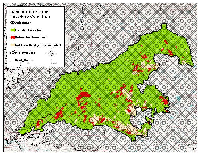
Hancock Fire
| vegetation type | treatments NOT permitted | treatments permitted | treatments permitted | total within fire perimeter | |||
|---|---|---|---|---|---|---|---|
| deforested condition | forested condition | deforested condition | forested condition | deforested condition | forested condition | ||
| steep ground ( > 30 % slope) |
flat ground ( < 30 % slope) |
||||||
| alpine | 0 | 8 | 0 | 0 | 0 | 0 | 8 |
| fir types | 76 | 1,132 | 0 | 0 | 0 | 0 | 1,208 |
| pine types | 0 | 0 | 0 | 0 | 0 | 0 | 0 |
| Douglas -fir | 370 | 12,238 | 0 | 126 | 0 | 16 | 12,750 |
| mixed conifer types | 654 | 4,134 | 0 | 0 | 0 | 0 | 4,788 |
| closed cone conifers | 0 | 0 | 0 | 0 | 0 | 0 | 0 |
| coastal conifer / cypress | 0 | 0 | 0 | 0 | 0 | 0 | 0 |
| pj | 0 | 0 | 0 | 0 | 0 | 0 | 0 |
| hardwood | 284 | 1,137 | 0 | 0 | 0 | 0 | 1,421 |
| sub total | 1384 | 18649 | 0 | 126 | 0 | 16 | 20,175 |
| shrub / non-forest | 1,644 | ||||||
| other ownership | 6 | ||||||
| total | 21,825 | ||||||
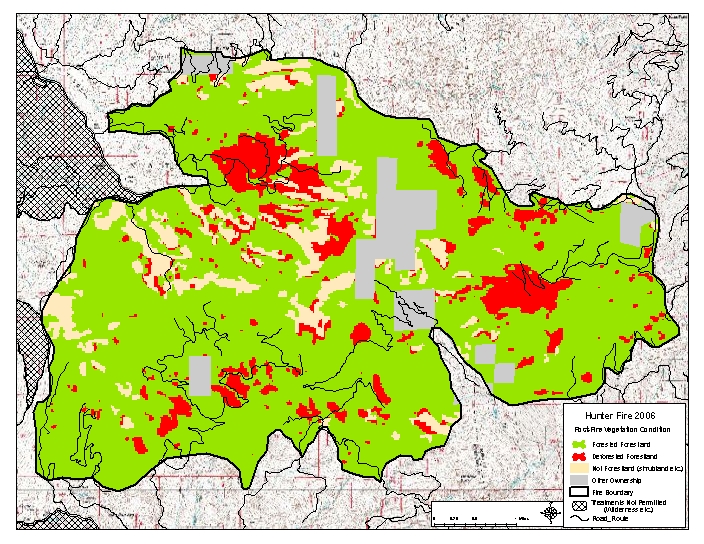
Hunter Fire
| vegetation type | treatments NOT permitted | treatments permitted | treatments permitted | total within fire perimeter | |||
|---|---|---|---|---|---|---|---|
| deforested condition | forested condition | deforested condition | forested condition | deforested condition | forested condition | ||
| steep ground ( > 30 % slope) |
flat ground ( < 30 % slope) |
||||||
| alpine | 0 | 0 | 0 | 0 | 0 | 0 | 0 |
| fir | 0 | 0 | 0 | 2 | 0 | 26 | 161 |
| pine | 0 | 0 | 7 | 187 | 7 | 161 | 362 |
| Douglas -fir | 0 | 10 | 351 | 3,620 | 501 | 2,708 | 7,190 |
| mixed conifer | 0 | 6 | 334 | 2,426 | 195 | 1,759 | 4,720 |
| closed cone conifers | 0 | 0 | 0 | 0 | 0 | 0 | 0 |
| coastal conifer / cypress | 0 | 0 | 0 | 0 | 0 | 0 | 0 |
| pinyon juniper | 0 | 0 | 0 | 0 | 0 | 0 | 0 |
| hardwood | 0 | 0 | 0 | 0 | 0 | 0 | 0 |
| sub total | 0 | 16 | 692 | 6,235 | 703 | 4,654 | 12,433 |
| shrub / non-forest | 1,506 | ||||||
| other ownership | 1,218 | ||||||
| total | 15,157 | ||||||
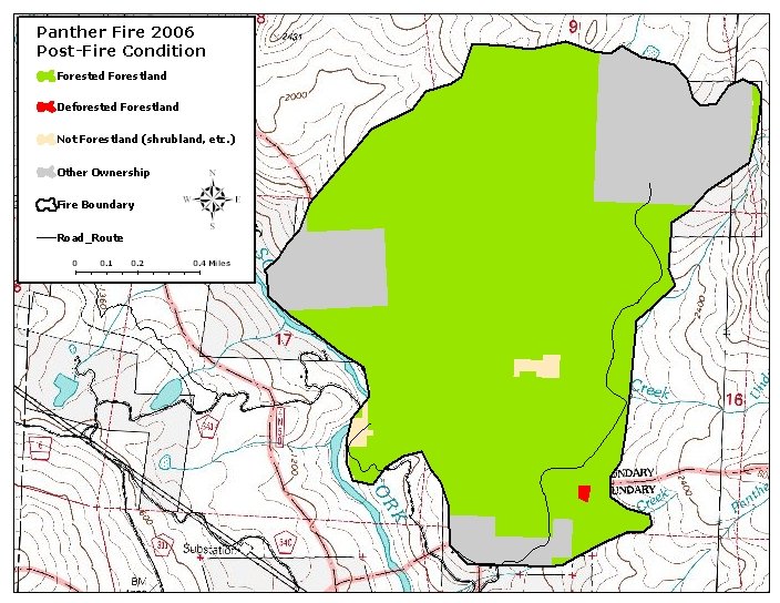
Panther Fire
| vegetation type | treatments NOT permitted | treatments permitted | treatments permitted | total within fire perimeter | |||
|---|---|---|---|---|---|---|---|
| deforested condition | forested condition | deforested condition | forested condition | deforested condition | forested condition | ||
| steep ground ( > 30 % slope) |
flat ground ( < 30 % slope) |
||||||
| alpine | 0 | 0 | 0 | 17 | 0 | 9 | 26 |
| fir types | 0 | 0 | 0 | 0 | 0 | 0 | 0 |
| pine types | 0 | 0 | 0 | 0 | 0 | 0 | 0 |
| Douglas -fir | 0 | 18 | 0 | 407 | 0 | 202 | 626 |
| mixed conifer types | 0 | 0 | 0 | 10 | 0 | 14 | 24 |
| closed cone conifers | 0 | 0 | 0 | 0 | 0 | 0 | 0 |
| coastal conifer / cypress | 0 | 0 | 0 | 0 | 0 | 0 | 0 |
| pj | 0 | 0 | 0 | 0 | 0 | 0 | 0 |
| hardwood | 0 | 8 | 0 | 63 | 0 | 17 | 89 |
| sub total | 0 | 27 | 0 | 497 | 0 | 242 | 765 |
| shrub / non-forest | 10 | ||||||
| other ownership | 215 | ||||||
| total | 990 | ||||||
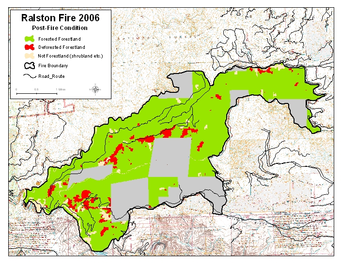
Ralston Fire
| vegetation type | treatments NOT permitted | treatments permitted | treatments permitted | total within fire perimeter | |||
|---|---|---|---|---|---|---|---|
| deforested condition | forested condition | deforested condition | forested condition | deforested condition | forested condition | ||
| steep ground ( > 30 % slope) |
flat ground ( < 30 % slope) |
||||||
| alpine | 0 | 0 | 0 | 0 | 0 | 0 | 0 |
| fir | 0 | 0 | 0 | 0 | 0 | 0 | 0 |
| pine | 1 | 10 | 100 | 1,758 | 51 | 260 | 2,179 |
| Douglas -fir | 0 | 0 | 0 | 0 | 0 | 0 | 0 |
| mixed conifer | 0 | 0 | 1 | 65 | 0 | 50 | 116 |
| closed cone conifers | 0 | 0 | 62 | 117 | 22 | 26 | 226 |
| coastal conifer / cypress | 0 | 0 | 0 | 0 | 0 | 0 | 0 |
| pinyon juniper | 0 | 0 | 0 | 0 | 0 | 0 | 0 |
| hardwood | 0 | 36 | 145 | 2,979 | 22 | 191 | 3,373 |
| sub total | 1 | 47 | 307 | 4,919 | 95 | 526 | 5,895 |
| shrub / non-forest | 338 | ||||||
| other ownership | 2,360 | ||||||
| total | 8,593 | ||||||
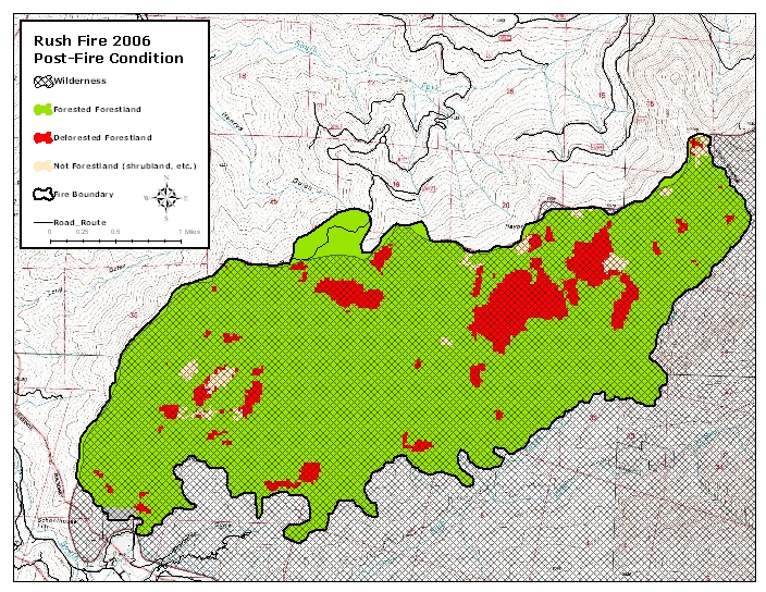
Rush Fire
| vegetation type | treatments NOT permitted | treatments permitted | treatments permitted | total within fire perimeter | |||
|---|---|---|---|---|---|---|---|
| deforested condition | forested condition | deforested condition | forested condition | deforested condition | forested condition | ||
| steep ground ( > 30 % slope) |
flat ground ( < 30 % slope) |
||||||
| alpine | 0 | 0 | 0 | 0 | 0 | 0 | 0 |
| fir types | 105 | 324 | 0 | 7 | 0 | 19 | 454 |
| pine types | 0 | 0 | 0 | 0 | 0 | 0 | 0 |
| Douglas -fir | 21 | 481 | 0 | 0 | 0 | 6 | 508 |
| mixed conifer types | 337 | 3,221 | 0 | 98 | 0 | 30 | 3,686 |
| closed cone conifers | 0 | 0 | 0 | 0 | 0 | 0 | 0 |
| coastal conifer / cypress | 0 | 0 | 0 | 0 | 0 | 0 | 0 |
| pj | 0 | 0 | 0 | 0 | 0 | 0 | 0 |
| hardwood | 16 | 250 | 0 | 0 | 0 | 0 | 267 |
| sub total | 479 | 4276 | 0 | 105 | 0 | 55 | 4,915 |
| shrub / non-forest | 87 | ||||||
| other ownership | 13 | ||||||
| total | 5,014 | ||||||
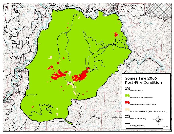
Somes Fire
| vegetation type | treatments NOT permitted | treatments permitted | treatments permitted | total within fire perimeter | |||
|---|---|---|---|---|---|---|---|
| deforested condition | forested condition | deforested condition | forested condition | deforested condition | forested condition | ||
| steep ground ( > 30 % slope) |
flat ground ( < 30 % slope) |
||||||
| alpine | 0 | 0 | 0 | 0 | 0 | 0 | 0 |
| fir types | 0 | 0 | 39 | 280 | 8 | 31 | 359 |
| pine types | 0 | 0 | 0 | 0 | 0 | 0 | 0 |
| Douglas -fir | 0 | 21 | 166 | 10,478 | 12 | 798 | 11,475 |
| mixed conifer types | 0 | 0 | 124 | 744 | 11 | 45 | 924 |
| closed cone conifers | 0 | 0 | 0 | 0 | 0 | 0 | 0 |
| coastal conifer / cypress | 0 | 0 | 0 | 0 | 0 | 0 | 0 |
| pj | 0 | 0 | 0 | 0 | 0 | 0 | 0 |
| hardwood | 0 | 0 | 10 | 2,194 | 0 | 91 | 2,295 |
| sub total | 0 | 21 | 338 | 13,696 | 32 | 965 | 15,053 |
| shrub / non-forest | 169 | ||||||
| other ownership | 72 | ||||||
| total | 15,294 | ||||||
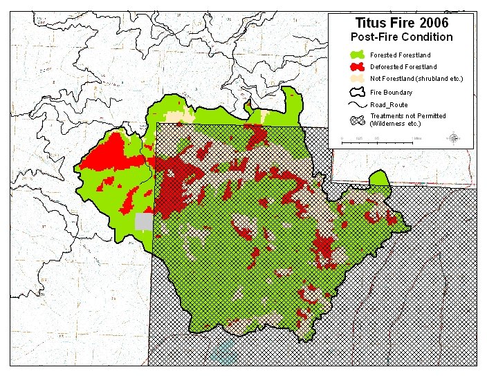
Titus Fire
| vegetation type | treatments NOT permitted | treatments permitted | treatments permitted | total within fire perimeter | |||
|---|---|---|---|---|---|---|---|
| deforested condition | forested condition | deforested condition | forested condition | deforested condition | forested condition | ||
| steep ground ( > 30 % slope) |
flat ground ( < 30 % slope) |
||||||
| alpine | 0 | 2 | 0 | 0 | 0 | 0 | 2 |
| fir | 106 | 875 | 0 | 32 | 0 | 5 | 1,018 |
| pine | 0 | 6 | 0 | 15 | 0 | 3 | 25 |
| Douglas -fir | 196 | 599 | 100 | 655 | 9 | 66 | 1,625 |
| mixed conifer | 284 | 1,477 | 1 | 95 | 0 | 4 | 1,862 |
| closed cone conifers | 19 | 9 | 4 | 0 | 0 | 0 | 32 |
| coastal conifer / cypress | 0 | 0 | 0 | 0 | 0 | 0 | 0 |
| pinyon juniper | 0 | 0 | 0 | 0 | 0 | 0 | 0 |
| hardwood | 39 | 0 | 112 | 47 | 13 | 5 | 217 |
| sub total | 645 | 2,969 | 216 | 844 | 23 | 83 | 4,780 |
| shrub / non-forest | 1,251 | ||||||
| other ownership | 40 | ||||||
| total | 6,071 | ||||||
Uncles Fire
| vegetation type | treatments NOT permitted | treatments permitted | treatments permitted | total within fire perimeter | |||
|---|---|---|---|---|---|---|---|
| deforested condition | forested condition | deforested condition | forested condition | deforested condition | forested condition | ||
| steep ground ( > 30 % slope) |
flat ground ( < 30 % slope) |
||||||
| alpine | 0 | 14 | 0 | 0 | 0 | 0 | 14 |
| fir types | 201 | 439 | 0 | 0 | 0 | 0 | 640 |
| pine types | 0 | 0 | 0 | 0 | 0 | 0 | 0 |
| Douglas -fir | 18 | 143 | 0 | 0 | 0 | 0 | 161 |
| mixed conifer types | 418 | 1616 | 0 | 0 | 0 | 0 | 2,034 |
| closed cone conifers | 0 | 0 | 0 | 0 | 0 | 0 | 0 |
| coastal conifer / cypress | 0 | 0 | 0 | 0 | 0 | 0 | 0 |
| pj | 0 | 0 | 0 | 0 | 0 | 0 | 0 |
| hardwood | 0 | 0 | 0 | 0 | 0 | 0 | 0 |
| sub total | 637 | 2212 | 0 | 0 | 0 | 0 | 2,849 |
| shrub / non-forest | 962 | ||||||
| other ownership | 0 | ||||||
| total | 3,811 | ||||||