
Official websites use .gov
A .gov
website belongs to an official government organization in the
United States.
Secure .gov websites use HTTPS
A lock
(
) or https:// means you've safely
connected to the .gov website. Share sensitive information only
on official, secure websites.


Forest Roads Status
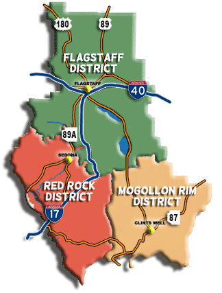
The road status for each of the districts on the Coconino National Forest is updated as the information becomes available and is listed separately by district.
Click the district on the map, or district button, to review road statuses.
If you need further information or have questions regarding any Forest Road, please call the appropriate District Ranger Station:
- Flagstaff Ranger Station: (928) 526-0866
- Red Rock Ranger Station: (928) 282-4119
- Mogollon Rim Ranger Station: (928) 477-2255
If you are not sure which district a particular road falls in, the detailed Coconino National Forest map (PDF, 8 MB) shows the exact district boundaries and Forest Roads.
BE AWARE
Forest road conditions can change drastically as you climb in elevation, especially during the winter months. If you are on a dry forest road in the desert area and you begin climbing, be aware that you may encounter deep snow and 4-wheel drive conditions as you climb that same forest road. Each year there are people who get stuck and must be rescued due to the drastic change in condition and not being prepared. Some of the roads that people experience this drastic change in the winter months include: Schnebly Hill Road, FR 214, FR 618 and FR 229.
-
Motor Vehicle Use Maps (MVUM)

The Digital Travel Map is an free resource for anyone headed out into the Coconino National Forest. Whether you're driving, hiking, riding, or exploring, you will find this full color, GPS-enabled map a handy reference to have on your mobile device. The map show trails, recreation sites, major landmarks, and forest boundaries in addition to the roads shown on the Motor Vehicle Use Map.