
Official websites use .gov
A .gov
website belongs to an official government organization in the
United States.
Secure .gov websites use HTTPS
A lock
(
) or https:// means you've safely
connected to the .gov website. Share sensitive information only
on official, secure websites.


Tule Canyon
| VISITOR GUIDE |
| Visitor Guide Home |
|
Giant Sequoia |
| Visit A Sequoia Grove |
| Northern Monument |
| Kings Canyon Scenic Byway |
| Hume Lake |
| Big Meadows |
| Southern Monument |
| Tule Canyon |
| Wishon Canyon |
| Western Divide Highway |
| Great Western Divide |
| Lloyd Meadow Road |
| Portuguese Pass |
|
Sequoia National Forest |
| Greenhorn Mountains |
| Kern Plateau |
| Upper Kern River |
| Lower Kern River |
| Lake Isabella |
| South Fork Wildlife Area |
| Whitewater and Lakes |
| Wilderness |
Tule Canyon
Giant Sequoia National Monument
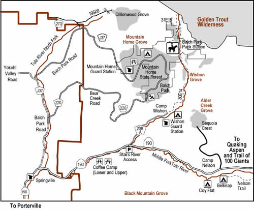
Tule River. Three forks of the Tule River drain the high mountain tops of the Great Western Divide to form Lake Success, a reservoir managed by the Army corps of Engineers located five miles above the city of Porterville. The North and the Middle Fork split above the foothill community of Springville. Highway 190 travels alongside the Middle Fork Tule River and Balch Park Road follows the North Fork.
As you travel up Highway 190 past Lake Success and just before the town of Springville is the Western Divide Ranger Station. Stop to pick up free brochures, travel information, or talk with one of the Forest Service employees. The Three Forest Interpretive Association (3FIA) offers books and interpretive materials for sale that will help you enjoy your visit.
The North and Middle Forks of the Tule River offer visitors great fishing, hiking, camping, and picnicking opportunities in a ruggedly beautiful canyon setting. In the lower canyon, Lower and Upper Coffee Camp day use areas provide parking, restrooms, and picnic sites. Overnight camping is allowed at developed campgrounds; Wishon, Belknap, and Coy Flat.
Water in the river always looks inviting, especially during the hot summer months, but it can be quite dangerous. Be extra careful along rivers and streams; falling in is as dangerous as swimming. Once in a river, getting out can be nearly impossible. Rocks are smooth and slippery; swift, cold water rapidly saps your strength, watch children carefully.
Fishing is allowed on the Tule River Year-round with a valid California fishing license. Licenses can be purchased at local retailers. The California Department of Fish and Game stocks the Tule River at several locations, including Coffee Camp, Wishon and Belknap Campgrounds. Be sure to stop by the ranger station for more information on regulations or visit the fish and Game website at www.dfg.ca.gov.
Belknap Grove Complex lines the upper reaches of the Middle fork of the Tule River and is easy to reach by car from May through mid-November. It includes the Wheel Meadow, McIntyre, and Belknap Groves with beautiful old-growth sequoias. The Nelson Trail (Forest Trail 31E30) travels along the river from Belknap Campground to Quaking Aspen where the Middle Fork of the Tule River originates.
California Land Management (CLM). Most developed campground areas on the Forest operate under a concessionaire permit with CLM. For additional information, please visit www.clm-services.com or call their Hume Lake office at 559-335-2232, their Springville office at 559-539-3004, or their Lake Isabella office at 760-376-1815.
| Campgrounds | Elevation | Sites | Season | Max. Trailer | Potable Water | Remarks |
|---|---|---|---|---|---|---|
| Belknap | 4800 | 15 | May-Nov | No | Yes | Reservations available |
|
Coy Flat S (Single Family) D (Double Family) |
5000 |
18-S 1-D |
May-Nov | 24’ | No | Reservations available |
| Day Use Areas | Elevation | Sites | Season | Potable Water | Remarks |
|---|---|---|---|---|---|
| Lower Coffee Camp | 2000 | 19 | All Year | Yes | Day Use Only, fee |
| The “Stairs” River Access | 2600 | 9 | All Year | No | Day Use Only |
| Upper Coffee Camp | 2100 | 19 | May-Nov | Yes | Day Use Only, fee |
| Trails | Trail # | Elevation | Miles | Remarks |
|---|---|---|---|---|
| Bear Creek | 31E31 | 5000-9000 | 8.0 | Belknap Grove, bicycles permitted |
| Nelson | 13E30 | 5300-6800 | 3.7 | Wheel Meadow/Mcintyre Groves, fishing, bicycles permitted |