
Official websites use .gov
A .gov
website belongs to an official government organization in the
United States.
Secure .gov websites use HTTPS
A lock
(
) or https:// means you've safely
connected to the .gov website. Share sensitive information only
on official, secure websites.


upper-kern-river.html
| VISITOR GUIDE |
| Visitor Guide Home |
|
Giant Sequoia |
| Visit A Sequoia Grove |
| Northern Monument |
| Kings Canyon Scenic Byway |
| Hume Lake |
| Big Meadows |
| Southern Monument |
| Tule Canyon |
| Wishon Canyon |
| Western Divide Highway |
| Great Western Divide |
| Lloyd Meadow Road |
| Portuguese Pass |
|
Sequoia National Forest |
| Greenhorn Mountains |
| Kern Plateau |
| Upper Kern River |
| Lower Kern River |
| Lake Isabella |
| South Fork Wildlife Area |
| Whitewater and Lakes |
| Wilderness |
Upper Kern River
Sequoia National Forest
The section of the Kern River between Lake Isabella and the Johnsondale Bridge is the North Fork of the Kern River and commonly called the Upper Kern. Designated a Wild and Scenic River, this section of the river is easily accessed by vehicle. Gray pines, scrub oaks, grass, and dry climate shrubs cling to steep, canyon walls while cottonwoods and willows line the river.
Overnight Along The Upper River. A number of developed campgrounds are available along the Upper Kern operated by concessionaire. For those interested in less developed opportunities, there are dispersed camping areas with portable toilets and trash bins. Tables, water, and fire rings are not provided. Don’t forget your valid California Campfire Permit for campfires, barbecues, stoves and lanterns during fire season. Camping is not allowed within 25 feet from the water’s edge.
Whitewater Boating. Upper Kern is popular during the spring and summer months (late May through July). Water flows are dependent upon snow melt and natural run-off. This 21-mile stretch of river has four whitewater boating sections with varying degrees of difficulty. For more details, see the Upper Kern page at Mountain and River Adventures website.
Recreation Service Partners
The Kern River Whitewater Outfitters-Guides. On the Sequoia National Forest, five outfitters provide guided whitewater trips on the Kern River. Please contact these companies for details of trips offered or to make reservations:
- Kern River Outfitter Guides: 760-376-3370,
www.KernRafting.com. - Whitewater Voyages, 800-400-7238, www.whitewatervoyages.com
- Mountain & River Adventures, 800-861-6553, www.mtnriver.com
- Sierra South, Inc., 800-457-2082, www.sierrasouth.com
California Land Management. There are 8 developed campgrounds operated under a concessionaire program with California Land Management (CLM) along the Upper and Lower Kern River. For additional information, please visit www.clm-services.com or call their Hume Lake office at 559-335-2232, their Springville office at 559-539-3004, or their Lake Isabella office at 760-376-1815.
Kern River Fish Hatchery. The California Department of Fish and Game manages the facility and the Friends of the Hatchery operate the visitor center and museums open to the public. Located at 14400 Sierra Way (Mountain Highway 99) hatchery hours are 10:00 am – 4:00 pm daily, Museum and Visitor Center hours are 10:00 am – 4:00 pm, Saturdays
and Sundays.
Kern River Valley Museum. Open Thursday through Sunday 10:00 am – 4:00 pm Kern River Valley Historical Society manages and maintains this museum. Archives and spectacular displays interpreting the rich and complex social, cultural and economic history of the Kern River Valley are offered to visitors without charge. Call (760) 376-6683 or visit the website at www.southern-sierra.com/Community/museum.
Bureau Of Land Management (BLM). A section of the Lower Kern just below the dam is managed by the BLM. White water boating activity along this section is managed in partnership with the Forest Service.
Along The Upper And Lower Kern River
Swimming Is Not Recommended. Powerful currents, cold water temperatures, and underwater hazards such as fallen trees and rocks, can trap even the strongest swimmers. Drowning is the number one cause of accidental death along the Kern. Falling in is as dangerous as swimming. Children should always be wearing life preservers and be closely supervised.
Hiking. See list of trails below. Be sure to pick a trail that matches your experience and ability. When hiking we suggest having the proper clothing, changes in the weather can happen rapidly. Wear good hiking boots and break them in before your hike! Always carry plenty of water, a first aid kit, map and food to meet your needs. Please remember to pack out what you pack in.
Fishing is a popular activity. A 3 day or 1 year California Fishing license is required and please know and follow California State Fish and Game regulations. Fishing is open year round along the Kern River. Live bait is allowed in the upper and lower sections and the limit is 5 trout per day/10 in possession. Above the Johnsondale Bridge special fishing restrictions apply, be sure to check local Fish and Game regulations.
Annual Kern River Use Permit. Good through April 30 of the following year, is required year round for EACH watercraft. Permits are issued at the Forest Services offices. A Coast Guard approved personal flotation device must be readily accessible, properly fit, and in good condition, for each member of the party. Daily water flow information is available from the Kern River Flow Phone. Flow information can be accessed toll-free at 877-537-6356 or locally at 760-376-8821.
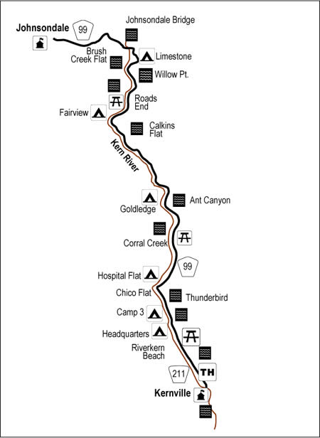
| Campgrounds | Elevation | Sites | Season | Max. Trailer | Potable Water | Remarks |
|---|---|---|---|---|---|---|
| Camp 3 | 2800 | 52 | 30’ | Yes | Reservations available | |
| Fairview | 3500 | 55 | 45’ | Yes | Reservations available, 3 accessible campsites, multi-family groupsites | |
| Goldledge | 3200 | 37 | 30’ | Yes | Reservations available | |
| Headquarters | 2800 | 44 | 27’ | Yes | Reservations available, 1 accessible campsite | |
| Hospital Flat | 3000 | 40 | 30’ | Yes | Reservations available | |
| Limestone | 3800 | 22 | 30’ | No | Fee required |
| Day Use Areas | Elevation | Season | Potable Water | Remarks |
|---|---|---|---|---|
| Brush Creek Flat | 3800 | open parking, compacted dirt surface | ||
| Corral Creek | 3000 | open parking, compacted dirt surface | ||
| Riverkern Beach | 2650 | roadside parking, steep paths, rocky and sandy surface |
| Trails | Trail # | Elevation | Miles | Remarks |
|---|---|---|---|---|
| Whiskey Flat | 32E35 | 2800-3600 | 14.5 | Easy to moderate. Parallels the Kern River, good fishing spots. |
| Cannell | 33E32 | 2800-7520 | 12.0 | Moderate to strenuous. Magnificent views of the Kern River Valley |
| Rincon | 33E23 | 3680-4640 | 19.5 | Moderate to strenuous. Good fishing, some nice undeveloped camping. |
| Packsaddle Cave | 33E34 | 3600-4500 | 2.3 | Moderate. Bring a flashlight to explore the cave. |
| Flynn Canyon | 32E33 | 3600-6000 | 3.9 | Moderate to strenuous. |
| Tobias | 32E34 | 3600-6400 | 4.6 | Moderate to strenuous. Good fishing. |
| River Trail | 33E30 | 3760-4000 | 5.2 | Easy to moderate. Follows the Kern River. Good access for fishing. Suitable for day hikes or overnight backpack trips. |
Hiking Handouts: Hiking Trails of Upper Kern Canyon (PDF - 109k)