
Official websites use .gov
A .gov
website belongs to an official government organization in the
United States.
Secure .gov websites use HTTPS
A lock
(
) or https:// means you've safely
connected to the .gov website. Share sensitive information only
on official, secure websites.


Lost River Ranger District - Borah Peak
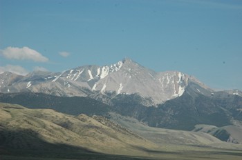 Welcome to the Lost River Ranger District's Borah Peak home page. At an elevation of 12,662 feet Borah Peak is the highest peak in Idaho. We hope you find the information on this page useful in planning your climb and we hope you have an enjoyable trip. You can view our Borah Peak climbing information letter by clicking here. If you have any questions or comments please contact our district using the sources.
- Current Weather Forecast - National Weather Service forecast for the Lost River-Pahsimeroi area
Alternate Climbing Routes
The are several other climbing routes to the summit of Borah Peak. All of these routes require varying degrees of technical climbing.
Traditional Climbing Route (Southwest Ridge Route)
Jumpoff Point: Borah Peak Trailhead
- Access to trailhead - Map showing access routes to trailhead
- Borah Peak Trailhead - Directions to and information on the Borah Peak Trailhead
- Climbing Route - Photograph showing the traditional climbing route to the summit
Elevation of Jumpoff Point: 7,400 feet
Elevation of Summit: 12,662 feet
Total Elevation Gain: 5,262 feet
Total Distance (one-way): 3.5 miles
Additional Links:
-
2015 Borah Glacier Report (known as Otto Glacier at the time the report was written).