Official websites use .gov
A .gov
website belongs to an official government organization in the
United States.
Secure .gov websites use HTTPS
A lock
(
) or https:// means you've safely
connected to the .gov website. Share sensitive information only
on official, secure websites.


Lost River Ranger - Climbing Information Letter
Dear Forest User:
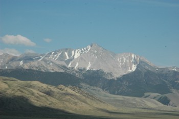
We are happy you have chosen to visit the Lost River Ranger District on the Salmon-Challis National Forest - THE TOP OF IDAHO. Of Idaho's 25 highest mountains, 24 are in our District. The two highest, Borah Peak and Leatherman Peak, are on the Lost River Range.
It is a pleasure to assist you with information on climbing Borah. The climb to the summit is not very difficult in terms of being complex, but it can be quite fatiguing due to the steepness of slope. The view of the surrounding mountains and valleys is spectacular and a tremendous reward for the effort.
Idaho's highest peak is reached from U.S. highway 93 by driving north of Mackay (21 miles) or south of Challis (33 miles). Between mileposts 129 and 130 signs indicate the "Mt. Borah Trailhead" turnoff. About two and a half miles brings you to a large flat area provided for trailers and motor homes which is just before the road turns to the left and then switches back across the base of a foothill leading to the new trailhead.
This trailhead is for regular vehicles only. Four campsites are available and each is equipped with a fire ring and table. At the end of the road is a turn-around area and parking for day hiking and picnicking. No garbage pickup is available so if you pack it in, you should pack it out. There are toilet facilities but no water is available.
No permits are required for climbing, camping or for building fires at the present time. We encourage those who build fires for heat or cooking to always check the fire danger rating before going out. If fire conditions are extreme, no fires will be permitted.
The climb starts at an elevation of about 7400 feet. The trail takes off from the trailhead turn-around area and goes up the sagebrush/grass slope to the ridge. The route ascends over 5200 feet elevation to the summit in less than 3 ½ miles of trail.
The real climb begins as this trail goes up the brutally steep west ridge of Borah. Emerging above timberline, the route continues to follow this ridge which is not as steep as the initial climb and after a short distance, reaches another steep portion which involves scrambling, "Chicken Out Ridge". This knife-like ridge with the more dangerous slope to the north side involves using both hands as well as feet to maneuver over and around the rocks. The route continues to follow the ridge and crosses a steep couloir that is usually draped with packed snow. (Some do not follow the ridge but use a trail through the shale on the north side of the ridge after crossing the couloir - snowfield. The shale is not stable and will shift down causing you to scramble a few feet back up to the trail.) The trail curves around to the north ascending the steep south ridge and slope of Borah Peak.
The climb rated as difficult is classified as a day trip and should take the average hiker 6 to 7 hours. The round trip should average about 10 to 12 hours, not counting time at the top. Some like to make it a two day trip by camping on the ridge the first night.
The Lemhi Mountain range lies to the east and northeast; Salmon River mountains to the north; the White Clouds, Boulders and Sawtooths to the west; the Pioneer and White Knob mountains to the southwest; then Leatherman Peak (Idaho's 2nd highest mountain) lies to the south east.
The summit is marked with a U.S.G.S. survey marker and a register is placed nearby.
Ideal climbing conditions range from early July through themiddle of August when the snow level is at its lowest. When it's storming late in August, it is common for a couple of inches of snow to accumulate at the base of Borah.
Safety precautions we would like to emphasize are:
- Keep abreast of current weather conditions. Weather patterns of afternoon thunderstorms are common during the summer. Thunderstorms can buildup quickly within a few hours and can be frightening if caught on an exposed ridge.
- Do not take water from a stream. Even though cool and clear it may not always be as pure as it looks. Some streams contain Giardia. It's best to obtain your water for the climb from a municipal supply, a well, or you can boil it for at least one minute. Chemical purifiers are not always 100 percent effective. We don't want our forest visitors to go home with something they didn't bring with them.
- For sanitation purposes and to prevent the spread of disease please bury or cover all human waste. This will keep the landscape pristine and make the climb more pleasant for others.
The sharp line across the base of Borah runs over 20 miles and was formed during the Borah Earthquake in October of 1983. The quake measured 7.3 on the Richter Scale. Interpretive signs on the Double Springs Road at the Earthquake Information Site about 2 miles north of Borah Trailhead more fully explains the area quake. The enclosed brochures may be of interest to you.
A topo map of Borah is available at the Lost River Ranger District Office in Mackay.
If you have any questions or need further assistance, do not hesitate to contact our office at 208-588-3400. Have an enjoyable climb.