
Official websites use .gov
A .gov
website belongs to an official government organization in the
United States.
Secure .gov websites use HTTPS
A lock
(
) or https:// means you've safely
connected to the .gov website. Share sensitive information only
on official, secure websites.


Motor Vehicle Use Maps
Motor Vehicle Use Maps (MVUM) display National Forest System (NFS) roads, trails, or areas designated open to motorized travel. It also displays seasonal allowances and permitted uses by vehicle class, for example: highway-legal vehicles, vehicles 50 inches or less in width, motorcycles, etc.
Please Note: Routes not shown on the MVUM are not open to public motor vehicle travel. Routes designated for motorized use may not always have signs on the ground but will be identified on the MVUM.
It is the public’s responsibility to reference the most current MVUM to stay on designated roads, trails, and areas open to motor vehicle use. Be aware, designation of a road, trail, or area for motor vehicle use by a particular class of vehicle should not be interpreted as encouraging or inviting use, or to imply that the road or trail is passable, actively maintained, or safe for travel.
As a motor vehicle operator on a National Forest System road or trail you must comply with this map, as well as all Federal, State, and local laws and regulations. More information can be found on our OHV Road Riding Page.
The USDA Forest Service partners with Tread Lightly! a non-profit organization that leads a national initiative to promote the responsible use of motorized vehicles when recreating outdoors. By promoting responsible recreation through stewardship, education and communication, Tread Lightly! messaging focuses on responsible riding practices, reducing the impact on the environment and protecting natural and cultural resources.
Avenza Maps
Avenza Maps® is a mobile map app that allows you to download maps for offline use on iOS or Android smartphone or tablet, use your device’s built-in GPS to track your location on any georeferenced map, plot locations and photos, measure distance and area, and more.
You can install a free mobile version of Huron-Manistee National Forests Motor Vehicle Use Map (MVUM) on your device using Avenza Maps. Best of all, it lets you know exactly where you are while traveling on the National Forest!
Using the Electronic MVUM
Open the Avenza Maps app and tap the MVUM map you wish to use on the maps page to activate the map. Cellular coverage is not necessary for map use as long as your device has internal GPS (most do). All map content is cached on the device. Users may pan, zoom out, or zoom in. On-screen appearance of the Avenza Maps app differs slightly between Apple and Android devices. For more information, please visit the Avenza Maps website.
Get the App
Install the Avenza Maps app on your smartphone or tablet. The app is available free from the Apple Store (iPhones and iPads) or from the Google Play Store (Android smartphones and tablets). Use the links below or type “Avenza Maps” into the app store’s search function. Please note that your “App Store” user account ID and password may be required to download and install applications from the App Store.


Things to know about the Electronic MVUMs
- Adjusting the Travel Map while driving is a hazard to you, and to others. Don’t be a distracted driver. Pull over in a safe location if Travel Map adjustments, or extended viewing, are required
- WiFi-only tablets cannot provide true GPS positioning service. Only devices with 3G/4G/5G capability can provide true GPS positioning, even in the absence of cellular coverage. Steeply rising terrain, dense vegetation, or other overhead obstructions may significantly degrade GPS reception. GPS positioning consumes more power, so use of a power adapter approved for your device is recommended.
- Do not rely on phones or other electronic devices as a primary navigational tool, always have a paper map available as well.
- The map’s feature labels are static and, in some situations, could be hidden off-screen.
- Remember to update your maps when a new MVUM is released (usually yearly).
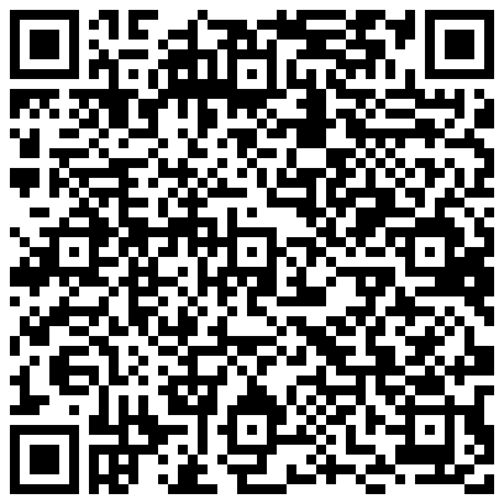
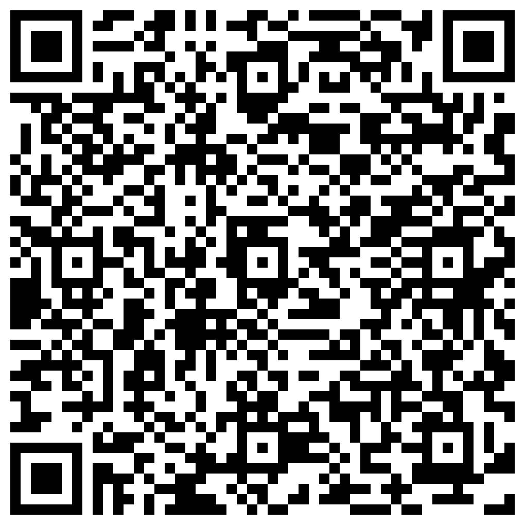
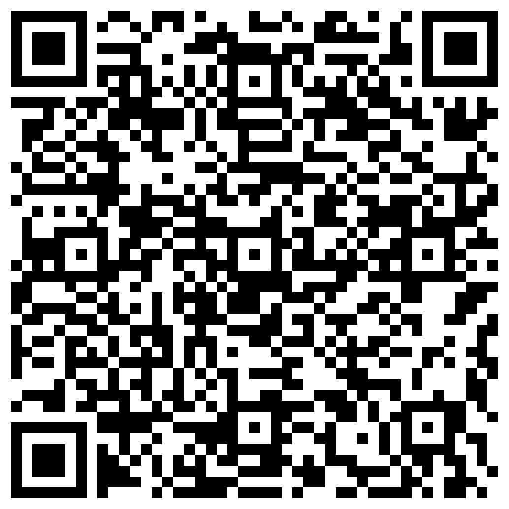
If you have the Avenza App on your digital device, you can download the Huron-Manistee’s MVUM maps for use on Avenza. To upload the electronic Huron-Manistee National Forest Motor Vehicle Use Map from Avenza on your smartphone or tablet, scan the QR Codes below:
 |
 |
 |
 |
 |
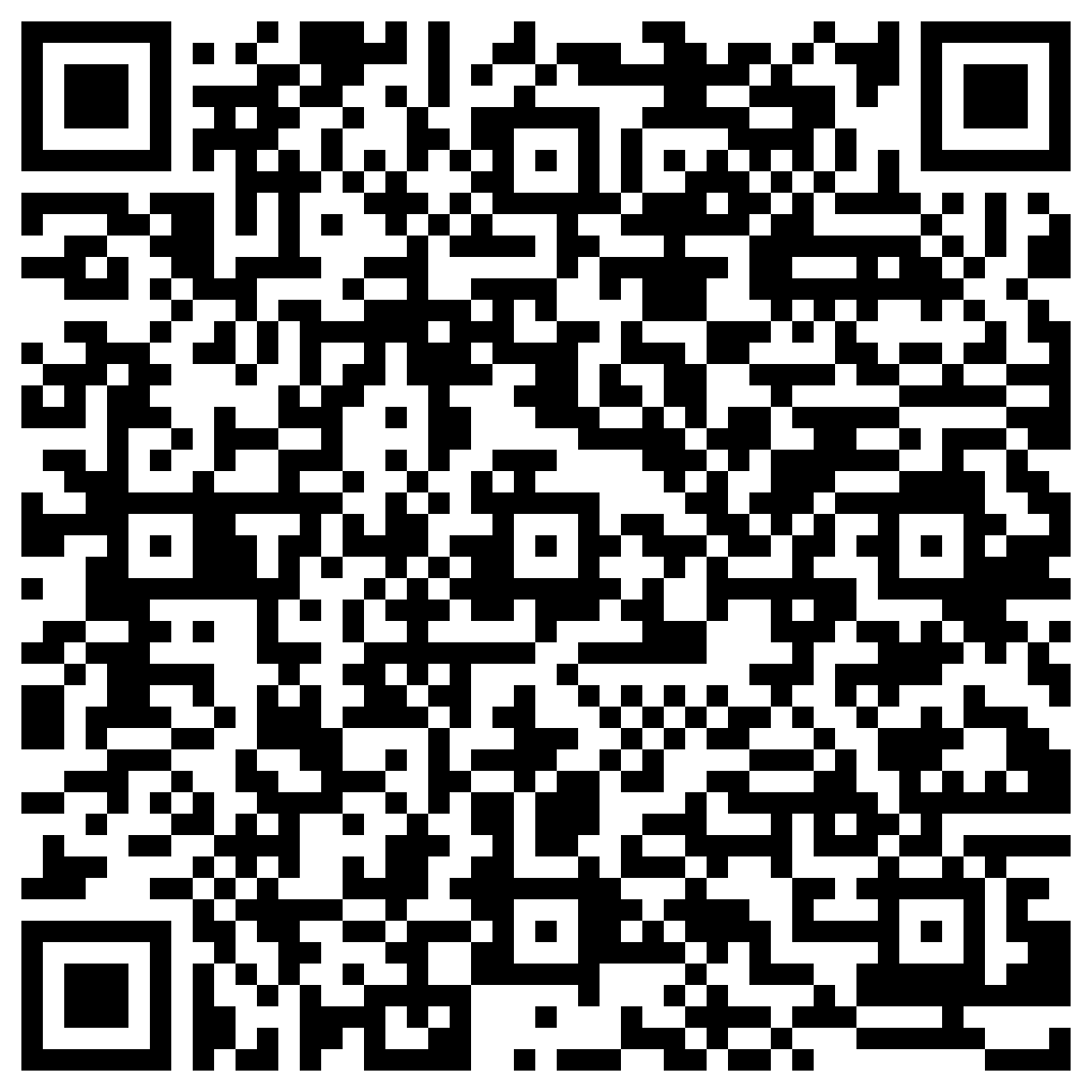 |
| Baldwin White Cloud South | Baldwin White Cloud North | Cadillac Manistee West | Cadillac Manistee East | Mio | Huron Shores |
Download MVUM Maps to your computer in .pdf form
Paper Maps Available
Visit, or call, one of our offices to obtain full-sized, black and white paper versions of the map(s).