

Welcome to Gifford Pinchot National Forest
Hello! We have transitioned our public website to a new web platform to better serve the public. With so many pages to update, some content may take longer to appear. Some old content has been archived during this process, as well.
We appreciate your patience as we work to make it easier to find information and explore your national forests. Please send us an email if there is something you can't find: Contact Us!
Gifford Pinchot National Forest includes over 1.3 million acres of forest, wildlife habitat, watersheds & mountains, including Mt. Adams & Mount St. Helens National Volcanic Monument.


Ready To Summit Mt Adams?

Road and trail conditions can change rapidly depending on the season. If you are interested in climbing Mt. Adams, make sure you review the latest Climbing Conditions Report, so you are ready and prepared for your trip.
Lewis River Recreation Area
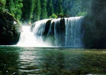
The Lewis River Recreation Area is a 10-mile corridor, situated alongside the Lewis River and Forest Road 90 within the Gifford Pinchot National Forest. It contains the Lewis River Trail and associated waterfall viewing.
Spirit Lake
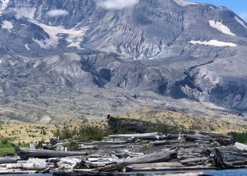
The Gifford Pinchot National Forest is responsible for operating, maintaining, and repairing the 1.6 mile Spirit Lake tunnel and the engineered channels at Castle and Coldwater Lakes. Constructed in 1985, the tunnel provides the only outflow for Spirit Lake. The Forest Service is currently developing a collaborative strategy to create more sustainable and safer options for long term management of Spirit Lake Outflow to achieve ecological, economic and public safety needs.
