

Wilderness
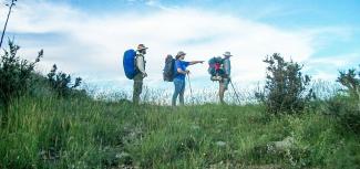
Prescott National Forest's eight Wilderness Areas are ideal places to view wildlife, hike, ride horses, backpack, find solitude, and connect with nature. The USFS Washington Office website explains more about designated Wilderness and how you can become involved in helping care for this precious resource.
Apache Creek Wilderness
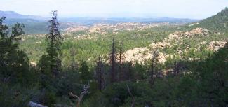
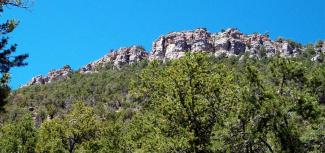
Rolling hills of juniper and pinyon interspersed with granite outcrops characterize this small, remote and relatively rugged wilderness. Established in 1984, the 5,628-acre wilderness features three natural springs and several important riparian areas including Apache Creek. Elevations range from 5,200 to 6,900 feet and the area provides excellent habitat for mountain lion and numerous bird species.
Location: Remote, accessed via unpaved roads, high clearance vehicles recommended; near Juniper Mesa Wilderness; western edge of the Chino Valley Ranger District
There are 2 maintained trails within this wilderness: Apache Creek Loop #9903 and Apache Creek Trail #9905.
Apache Creek Wilderness on Wilderness.net
Printable Trail Description and Map (595 KB PDF; 8.5” X 11”)
Castle Creek Wilderness
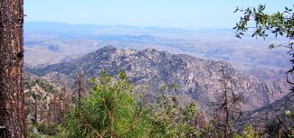
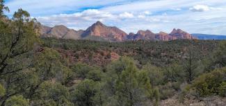
This wilderness of 25,517 acres sits on the eastern slopes of the Bradshaw Mountains and is characterized by extremely rugged topography with prominent granite peaks that overlook the Agua Fria River.
Elevations range from 2,800 and 7,000 feet. The primary vegetation at the lower elevations is saguaro cactus, palo verde, and mesquite. As the elevation increases, grassland species change into the chaparral community and the highest elevations have ponderosa pine, Arizona whiteoak, and alligator juniper.
Location: Bradshaw Ranger District in the general vicinity of the Town of Crown King and the Horsethief Basin Recreation Area; accessed via unpaved roads; high clearance vehicles recommended
Castle Creek Wilderness on Wilderness.net
Horsethief Basin Brochure (12.8 MB PDF)
Cedar Bench Wilderness
Trails in the Cedar Bench Wilderness include Goat Springs Trail #542, Lower Cedar Bench Trail #540, and Chasm Creek Trail #164.
Location: Verde Ranger District; near Pine Mountain Wilderness; south of the Town of Camp Verde; Accessed via unpaved roads, high clearance 4WD vehicles recommended
Granite Mountain Wilderness
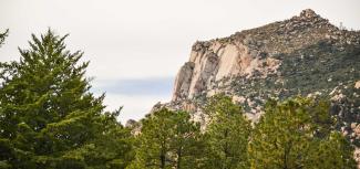
An easily identifiable landmark located on the outskirts of Prescott, this 9,799-acre wilderness is characterized by rugged granite boulders, some the size of a house, stacked one atop the other to elevations that exceed 7,600 feet. The Metate Trailhead in Granite Basin is the primary portal to the wilderness which has two maintained trails. Hiking groups are limited to 15 people; equestrian groups to 10 animals. Dogs must be on a leash at all times.
Location: Most used Wilderness Area on the forest; just north of the City of Prescott; easy access via the Granite Basin Recreation Area and the Williamson Valley Trailhead
Campfires are prohibited, however, stoves fueled by propane or white gas are permitted. There is no camping within 200 feet of Granite Mountain Trail #261. For rock climbing, maintenance of existing fixed anchors is permitted, but no new anchors are allowed.
Trails within this wilderness include Granite Mountain Trail #261, Tin Trough springs Trail #308, and Baby Granite Loop.
Juniper Mesa Wilderness
Established in 1984, the 7,554-acre wilderness is characterized by the flat-topped mesa from which its name is derived. Elevations range from 5,600 feet on the southwest side near Juniper Spring to 7,000 feet on the west side near George Wood Canyon and Gobblers Knob. The primary vegetation on the steep southern slopes in pinon pine and Utah juniper, and on the northern slopes, ponderosa pine and alligator juniper.
A great variety of wildlife can be found in the area. Black bear, elk, mule deer, bobcat, and Abert's squirrel are relatively common. There are no perennial water sources present, and the reliability of springs may be questioned during long periods of dry weather.
Location: Remote, accessed via unpaved roads, high clearance vehicles recommended; near Apache Creek Wilderness; western edge of the Chino Valley Ranger District
There are 7 maintained trails within this wilderness: #3, #20, #100, #9853, and #940.
Pine Mountain Wilderness
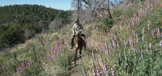
The southern-most wilderness area on the Prescott National Forest shares a boundary with the Tonto National Forest. Recreational opportunities include: hiking, backpacking, and horse riding. Mechanized equipment of any kind is not allowed in wilderness areas. Trails in the Pine Mountain Wilderness include Nelson Trail #159, Buck Basin Trail #158, Pine Flat Trail #165, Tule Rim Trail #162, Verde Rim Trail #161 and Willow Springs Trail #12.
Location: Remote; near Cedar Bench Wilderness; Verde Ranger District (shared with Tonto National Forest); access via Dugas Road off I-17; high clearance 4WD vehicles recommended
Sycamore Canyon Wilderness
Established in 1935, this area contains a unique canyon-land environment. The canyon cuts through the Mogollon Rim which marks the southern edge of the Colorado Plateau. It winds for 20 miles along Sycamore Creek and at places stretches 7 miles from rim to rim. Wind and water have exposed 7 geological associations of plants and animals set in a spectacular setting of red sandstone, white limestone, and brown lava. Camping is limited by the often-unreliable water sources.
Location: Largest Wilderness Area on the forest; Chino Valley and Verde Ranger Districts on the Prescott NF; shared with the Kaibab and Coconino National Forests; Accessed via unpaved roads, high clearance vehicles recommended
There are 13 maintained trails within this wilderness: #52, #54, #61, #66, #68, #117, #9017
Woodchute Wilderness
This small wilderness offers relatively easy access and spectacular views of the San Francisco Peaks and panoramic vistas of central Arizona. Created in 1984, the 5,923-acre wilderness ranges in elevation from 5,500 to 7,800 feet. Ponderosa Pine is the dominate overstory species located at the upper elevations which gradually changes to pinon pine and Utah juniper at the lower and relatively drier elevations.
Location: Verde Ranger District; Between Jerome and Prescott Valley, AZ; easy access via Mingus Mountain Scenic Route (Highway 89-A), and Forest Road 106 which is unpaved but suitable for most passenger vehicles
There is 1 maintained trail within this wilderness: #102
Woodchute Wilderness on Wilderness.net
Mingus Mountain Brochure NOTE- Brochure Correction: Mingus Mountain Campground and Picnic Site do not have electricity available at this time.