

2020 Awardees of the Citizen Science Competitive Funding Program
The following projects have been selected to receive up to $30,000 from the Citizen Science Competitive Funding Program (CitSci Fund). The CitSci Fund supports collaborative citizen science efforts where partners, volunteers, and the Forest Service work together in the pursuit of sound science and meaningful community and volunteer engagement.
With the funds available, Ecosystem Management Coordination was able to fully fund eleven projects totaling $199,092.
Subscribe to our email list to receive updates on the CitSci Fund.
2020 Total Submissions: 62
Funding Available: $200,000
Number of Projects Funded: 11
CitSci Fund Incubator Previous Recipients: 4
Phase 1 - Ideation (up to $10,000)
Connecting Communities to Riverscapes for a Resilient Sabana River Corridor, Luquillo Experimental Forest
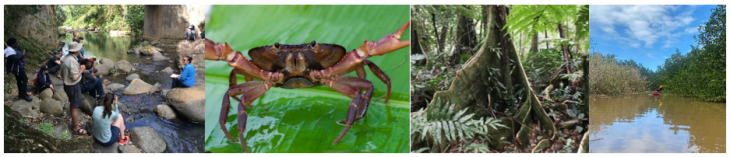
Left to right: A group of international scientists discuss recreation and water quality, a riparian crab, buttresses of a wetland tree, kayaking in mangroves and estuary of the Sabana river (USFS photo/Jerry Bauer/Samuel Moya/Carlos Rodriguez).
Location: Sabana Field Research Station, International Institute of Tropical Forestry, Puerto Rico
Partner Project Lead: Ramón Pérez-Castillo, Coordinator, ECOSOL
Forest Service Project Lead: Tamara Heartsill-Scalley, Research Ecologist, International Institute of Tropical Forestry
Funding Award: $10,000
Citizen scientists will collaborate to develop a database of water quality parameters, riparian zone conditions and aquatic fauna that will serve as a source of information for the community to facilitate adaptive management of resources and recreational components of the Sabana River.
The Sabana River connects headwaters in El Yunque National Forest with wetlands and beaches along the coast in the North East Ecological Corridor, Puerto Rico. The project will include inventories and monitoring that will provide opportunities to connect people to the river and engage in its stewardship. The Sabana River is an important component of the community, tied to their livelihoods and well-being because it serves as a major source of water supply for consumption and as a recreational destination for locals and tourists. Volunteers will be engaged in river safety orientations, hands-on learning about river fauna and water quality, and workshops from regional experts. Expected outcomes include collaborative and peer learning, sharing cultural river knowledge, and opportunities to learn about environmental issues.
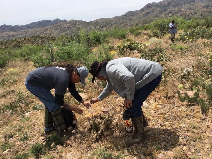
Gully Busters – Erosion Mapping in the Verde River Watershed

One of many actively expanding gullies on the Red Rock Ranger District of the Coconino National Forest. Citizen scientists will be assisting in the mapping of such features so that they can be prioritized for stabilization (USFS photo).
Location: Coconino National Forest, Arizona
Partner Project Lead: Tracy Stephens, Habitat Restoration Manager, Friends of the Verde River
Forest Service Project Lead: Tom Runyon, Hydrologist, Coconino National Forest
Funding Award: $10,000
Citizen scientists will gather data that will aid the Forest Service in prioritizing efforts to reduce accelerated erosion on lands managed by the Coconino National Forest within the middle Verde River Watershed. The project will include developing a protocol for monitoring and mapping headcuts and creating a volunteer training curriculum usable by both staff and volunteers.
The Verde River Watershed is a unique landscape and headcuts can affect water quality, scenery aesthetics, and barriers for foot, hoof, wheeled, and motorized travel. Volunteers seeing first-hand and learning about their impacts, will be a striking illustration of how our ecosystem is changing.
Through the data collection, we will enhance the capacity of the Coconino National Forest and Friends of the Verde River to understand the total picture of erosion issues throughout portions of the middle Verde Watershed and will be able to develop an informed plan for restoration.
MiWaterNet: Creating Freshwater Stewards Through River Monitoring
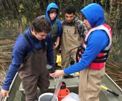
High school students test water samples in a Michigan lake (USFS photo).
Location: Hiawatha National Forest, Michigan
Partner Project Lead: Ashley Moerke, Professor, Center for Freshwater Research and Education, Lake Superior State University
Forest Service Project Lead: Micah Reuber, Forest Biologist, Hiawatha National Forest
Funding Award: $9,930
Volunteers made up of high school and university students will participate in the development of a water monitoring network (MIWaterNet) in the Hiawatha National Forest, expanding the network beyond the capacity of the existing Hiawatha personnel. MiWaterNet will allow us to gain insights into current hydrological and water quality conditions, detect changes in these conditions in response to climate change, and develop management practices to accurately respond to resource issues. MiWaterNet will connect high school and university students to scientific concepts in river ecology, build watershed awareness, and appreciation for water resources.
The volunteers will be 11th and 12th graders enrolled in the Career Technology Education program at Lake Superior State University and undergraduates in the Freshwater Stewardship Corps which is a student organization promoting water awareness, conservation, and management. The students will work directly with Hiawatha professionals using sensor technology to understand watershed management issues and data needs.
Phase I of the MiWaterNet project will be evaluated based on organization of a working group of stakeholders, identifying priority water sensors and sensor locations within the HIA, and completion of a project plan and protocols that will guide implementation in Phase II.
Multi-Resource Monitoring of Rare Communities in the Red River Gorge of the Daniel Boone National Forest

Multiple resource monitoring within sandstone rock houses in the Red River Gorge (USFS photo).
Location: Daniel Boone National Forest, Kentucky
Partner Project Lead: Tara Littlefield, Conservation Supervisor/Botanist, The Office of Kentucky Nature Preserves
Forest Service Project Lead: Christina Wampler, District Biologist, Daniel Boone National Forest
Funding Award: $10,000
The Red River Gorge contains significant biological and cultural resources in sandstone cliff line environments that are extremely sensitive to human impacts. One biological resource of special significance is the recently delisted, endemic white-haired goldenrod which is a plant species that exists nowhere else on earth. Also of importance is an archaeological national register district, with 442 contributing sites in the Gorge. Through citizen science, these important areas can be monitored more frequently and intensely than is possible with Forest Service and partner time alone.
Engaging the public in data collection through this citizen science program will create opportunity for public education and a means to develop a vested interest by the community in protecting these unique resources. Our goal is to develop a streamlined protocol for monitoring the biological and cultural resources that will result in quality data that is reliable enough to inform management decisions, but will not create negative impacts on the habitat, species, or cultural resources monitored, and that is realistically implementable by volunteers with moderate training.
Ideally, a greater sense of public stewardship of the land and understanding of the challenges faced by public land management agencies will be gained. Additionally, volunteer collected data will be used to help protect rare, non-renewable cultural resources of the Red River Gorge and generate understanding of how unmitigated recreation can degrade sensitive biological and cultural resources.
Phase 2 - Development and Implementation (up to $30,000)
Citizen Science and the Search for Disease Resistance to Rapid ʻōhiʻa Death
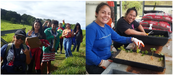
Left: Students returning from taking phenology measurements on native trees in a native forest conservation area on Hawaii Island; Right: Americorp members preparing ʻōhiʻa cuttings for rooting and propagation – with plants to be used for disease resistance screening (USFS photo).
Location: Pacific Southwest Research Station, Laupāhoehoe Unit of the Hawai‘i Experimental Tropical Forest Hawai‘i
Partner Project Leads: Blaire Langston, Teaching Change Coordinator, and Creighton Litton, Professor, University of Hawai‘i at Mānoa; Rebekah Ohara, Director of Programs, Akaka Foundation for Tropical Forests
Forest Service Project Lead: Christian Giardina, Research Ecologist, Pacific Southwest Research Station
Funding Award: $25,400
The Teaching Change partnership inspires local youth to be environmental stewards and pursue post-secondary education and careers in natural resource management. This new citizen science program will engage the Laupāhoehoe Community Public Charter School (LCPCS) in order to: (i) introduce students to the ecological importance of Hawaii’s most important tree species – Metrosideros polymorpha known locally as ʻōhiʻa – and teach methods for screening ʻōhiʻa for resistance to rapid ʻōhiʻa death; and (ii) increase Forest Service capacity to screen large numbers of ʻōhiʻa from the Laupāhoehoe Unit of the Hawai‘i Experimental Tropical Forest for disease resistance to rapid ʻōhiʻa death while building knowledge about Hawaii’s native ecosystems through intensive, experiential and place-based programming. This LCPCS-based citizen science project will advance understanding of a disease that presents an unprecedented threat to Hawaii’s native forests, paired with positive learning outcomes and concrete natural resources skills for LCPCS students, the majority of whom identify as Native Hawaiian. This citizen science will allow students to make a highly meaningful contribution to real world science and the protection of their native forests.
Leveraging Citizen Science to Map Lamprey Distributions in Oregon Using eDNA Methods
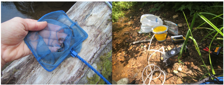
Left: A larval lamprey collected in an Oregon south coast stream. Right: eDNA sampling equipment used by citizen science volunteers (SSNERR photo).
*CitSci Fund Incubator Previous Recipient*
Location: Pacific Northwest (PNW) Research Station, Oregon
Partner Project Lead: Shon Schooler, Ecologist, South Slough Reserve
Forest Service Project Lead: Rebecca Flitcroft, Research Fish Biologist, PNW Research Station
Funding Award: $30,000
There are at least two native species of lamprey living in Oregon’s coastal watersheds, yet very little information is known about their distributions and population size. Obtaining distribution and population-status information can be labor intensive and distinguishing adult Western Brook Lamprey and Pacific Lamprey ammocetes requires specialized expertise. These constraints paired with a lack of prior management interest in lamprey population status has meant that lamprey data collection is often ancillary to other studies.
Environmental DNA (eDNA), is one technique to obtain species-specific lamprey data to aid in the development of accurate fish distribution maps. This technique lends itself to the use of volunteer networks to collect samples, since volunteers do not need to be experts in identification of juvenile lamprey. During Phase 1 of this project we tested several techniques for obtaining eDNA samples in Oregon coastal watersheds. Using what was learned, we will be able to expand our volunteer recruitment and engagement utilizing tested methodologies in Phase 2. This phase of the project will continue our partnership with the Forest Service National Genomics Center lab to process our DNA samples.
Partner agencies will benefit from the species-specific lamprey data and citizen scientists will gain an understanding of the scientific method and an appreciation for lamprey and their habitat. Students will meet several Life Science education standards.
Wood Products for Culture and Heritage

A high school student assists with carving paddles in a Northwest Coast Native
Location: Pacific Northwest Research Station, Alaska
Partner Project Lead: Andrew Thoms, Executive Director, Sitka Conservation Society
Forest Service Project Lead: Adelaide Johnson, Professional Hydrologist, Pacific Northwest Research Station
Funding Award: $30,000
This project has four goals that include 1) to better understand southeast Alaska Native wood resource needs for culture and heritage projects, availability of resources and value of products made from these resources, and to identify characteristics of forests where these resources originate; 2) to create student opportunities in underserved Native communities, foster engagement with elders, and enhance interest and participation in forest research and management; 3) to facilitate communication among Native communities, research scientists, federal and state managers/policy makers, and Tribal organizations and corporations; and 4) to provide information for managers to enhance access and use of forest products to perpetuate Alaska Native culture and art forms per “Standards and Guidelines for Plants and Timber” (Tongass Land Management Plan, USDA 2016).
This project will engage four communities composed largely of Tlingit Alaska Natives, the largest Tribe in southeast Alaska. Within each community – Angoon, Kake, Klawock, and Hoonah – we will work with Tribal environmental planners, Alaska Native carvers, Alaska Native high school student interns, local district Forest Service and Tribal foresters, and conservation organizations. This collaborative effort will allow for better valuation of community needs for wood products for culture and heritage, inclusion of stakeholders in relevant research, and creation of meaningful experiences for students by engaging with elders, learning about the importance of local resources, and getting exposure to research activities aimed at supporting forest policy. By integrating Alaska Native knowledge and youth directly in research, we will co-produce an inclusive forest resource assessment that will support future forest management and community needs.
Phase 3 – Ongoing Implementation and Knowledge Transfer
(up to $20,000)
Conservation Through Action – A Citizen Science Program for Jaguar and Ocelot Monitoring with Web-Based Management

Jaguar and Ocelot Monitoring Program Citizen Scientists (UArizona photo).
Location: Coronado National Forest, Arizona
Partner Project Lead: Dr. Melanie Culver, US Geological Survey, Assistant Leader - Arizona Cooperative Fish and Wildlife Research Unit and Assistant Professor, Wildlife and Fisheries Sciences, University of Arizona
Forest Service Project Lead: Angela Dahlby, Wildlife, Fish, and Rare Plants Program Manager, Coronado National Forest
Funding Award: $20,000
The overarching goal of this project is to aid conservation and management of endangered jaguar and ocelot in Arizona and conservation of the ecosystems that they depend on, through the monitoring of intact wildlife communities. It is critical, yet challenging, to have real-time data on endangered and other wildlife species to inform land management decisions. Coronado National Forest managers and partners are able to use the SPARC’d application – an open-source web-based image processing application that securely shares data with selected users worldwide – to query species distributions relevant to: climate data; vegetation data; water availability; specific photo/records of a species over time.
This 8-year project will continue the use of trail cameras to monitor jaguar, ocelot, and other wildlife, while also offering a unique opportunity for citizen scientists to conduct fieldwork alongside professional scientists within the Coronado National Forest. Among the 33 current citizen scientists, some have trail-camera expertise or wildlife tracking expertise, all are expert hikers and capable outdoor enthusiasts with knowledge of the outdoors. Through these experiences, the project connects these individuals and their communities to the rich, natural world in the mountains that surround them while at the same time increasing their knowledge in a spectrum of Science, Technology, Engineering and Math (STEM) disciplines. Volunteers engage in bi-yearly educational workshops and training that will allow them to be ambassadors for jaguar and ocelot conservation at the annual University of Arizona “Science City-Tucson Festival of Books” and in their communities.
Location of Plants Traditionally Used by American Indian Tribes to Improve Management of Federal Lands
Tribal members collect botanical resources for traditional use (USFS photo).
*CitSci Fund Incubator Previous Recipient*
Location: Kaibab National Forest & Tonto National Forest, Arizona
Partner Project Lead: Sara Souther, Assistant Research Professor, Northern Arizona University
Forest Service Project Lead: Nanebah Lyndon, Tribal Relations Staff Officer, Kaibab National Forest
Funding Award: $20,000
In consultation between the Forest Service and Arizona-based Tribal Governments, tribes requested that the Forest Service collect information on traditionally-used plants to develop management protocols that conserve important species when vegetation restoration treatments are conducted on the Four Forest Restoration Initiative (4FRI) project area. As 2018 Citizen Science Competitive Funding Program awardees, we addressed this need by developing a citizen science program to collect location information of traditionally-used plants which enabled 4FRI managers to develop management protocols ensuring long-term sustainability and availability of these resources for tribes, enhancing tribal access to these plants, and providing data to researchers to devise scientifically-based management and restoration protocols for these species.
We now propose to share this citizen science model with the agency by developing a document to guide project development based on our experience and by serving as informational support for other Forest Service units. Our citizen science guide will be comprehensive, describing the process of project development from ideation to evaluation and will target the topic of fostering and sustaining public engagement – lack of which is frequently cited as a leading cause of project failure.
Volunteer training and the supporting materials that are developed will also be incorporated into ongoing tribal youth outreach events, tribal kids’ camps, and tribal youth Ancestral Lands Crew projects. At the end of the project, participants will use the data collected to develop management suggestions and prioritize conservation efforts for particular plant species. These data will be shared with Forest Service land managers to improve natural resource management and will be made available to the tribes in order to facilitate the location and use of these culturally important species on Forest Service managed lands.
Monitoring the Status of the Columbia River Gorge Pika Population After the Eagle Creek Fire

A pika munches on vegetation in the Columbia River Gorge
*CitSci Fund Incubator Previous Recipient*
Location: Columbia River Gorge National Scenic Area, Oregon
Partner Project Lead: David Shepherdson, Deputy Conservation Manager, Oregon Zoo
Forest Service Project Lead: Brett Carre, Wildlife and Fisheries Programs Manager, Columbia River Gorge National Scenic Area
Funding Award: $13,762
American pikas are charismatic, easily identifiable, and residents of beautiful natural areas. The Columbia River Gorge (CRG), which is within the Columbia River Gorge National Scenic Area, is a unique habitat for pikas due to its abundance of vegetated talus at much lower elevations than is typical for this species which may make them particularly sensitive to environmental changes.
The 2017 Eagle Creek fire presented a unique opportunity to engage citizen scientists in post-fire monitoring as the resilience of pikas and other species of conservation concern is poorly understood. As a 2018 Citizen Science Competitive Funding recipient, this project developed a project to allow for more data on post-fire recovery of CRG pika populations and specifically, collect reliable monitoring data to help determine trends in population viability or key threats affecting the resilience of pikas and other potentially sensitive species.
This project provides experience for diverse volunteers, and their contributions not only leverage Forest Service resources, but also facilitate participants’ investment in local natural resources and their conservation. In Phase 3 of this project, expanded volunteer recruitment will allow for further project reach and data collection. The Project Leads will document protocols, policies and training materials to create a guide for future citizen science projects both at the Oregon Zoo and for the Forest Service. This guide will greatly facilitate the transfer of knowledge gained in this project to future projects.
Neighbors to Nature: Monitoring Wildlife, Plant Phenology and Recreational Use with Citizen Scientists on the Bridger-Teton National Forest in Jackson Wyoming
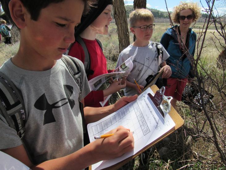
Local youth recording plant phenology observations (photo by Trevor Bloom).
*CitSci Fund Incubator Previous Recipient*
Location: Bridger-Teton National Forest, Wyoming
Partner Project Lead: Kate Gersh, Associate Director, Jackson Hole Wildlife Foundation
Forest Service Project Lead: Tim Farris, Trails/Wilderness Supervisor, Bridger-Teton National Forest
Funding Award: $20,000
Neighbors to Nature: Cache Creek Study organizes local volunteers to improve conditions for wildlife efficiently, while also forging lasting partnerships that form the foundation of a wildlife-friendly community. With the help of volunteers, wildlife/phenology/recreation-use data collection will continue to benefit wildlife, build a community of stewards, collect and share wildlife migration and observation data to support conservation, and educate the public on compatible coexistence between humans and wildlife.
This project was developed and began implementation in 2018 with Citizen Science Competitive Funding Program support. The goals for Phase 3 are to increase the number and diversity of citizen scientists in the community and achieve a sufficient number of total monitoring observations and total number of field days within the Cache Creek recreation area to paint an accurate picture about existing conditions and establish a baseline for trends.
Through this project engagement, students with the Friends of Pathway’s Youth Crew and students from the Jackson Hole Community School, enhance their scientific literacy. Wildflower Watch engages volunteers through direct monitoring of native and invasive flora and fauna of the forest. Citizen scientists participate with data entry but are also encouraged to support analysis and interpretation. Volunteers with Nature Mapping Jackson Hole make weekly commitments to monitor and report wildlife observations in the Greater Cache Creek area. This effort demonstrates the commitment of a community centered on the appreciation of our natural resources and contributes to data being collected throughout Teton County. We will share the best practices that have been gained along the way with this diverse set of partners and participants.