

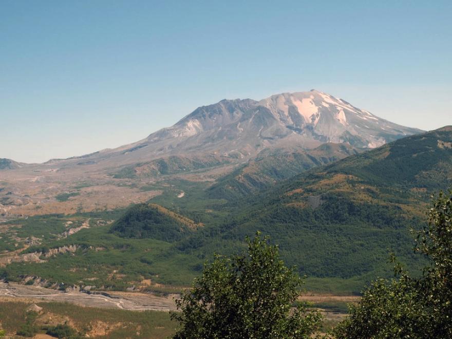
After two months of volcanic activity and shaken by an earthquake measuring 5.1 on the Richter scale, the north face of this tall symmetrical volcano collapsed in a massive rock debris avalanche. In a few moments this slab of rock and ice slammed into Spirit Lake, crossed a ridge 1,300 feet high, and roared 14 miles down the Toutle River.
The avalanche rapidly released pressurized gases within the volcano. A tremendous lateral explosion ripped through the avalanche and developed into a turbulent, stone-filled wind that swept over ridges and toppled trees. Nearly 150 square miles of forest was blown over or left dead and standing.
At the same time a mushroom-shaped column of ash rose thousands of feet skyward and drifted downwind, turning day into night as dark, gray ash fell over eastern Washington and beyond. Wet, cement-like slurries of rock and mud scoured all sides of the volcano. Searing flows of pumice poured from the crater. The eruption lasted 9 hours, but Mount St. Helens and the surrounding landscape were dramatically changed within moments.
A vast, gray landscape lay where once the forested slopes of Mount St. Helens grew. In 1982 the President and Congress created the 110,000-acre National Volcanic Monument for research, recreation, and education. Inside the Monument, the environment is left to respond naturally to the disturbance.
Amenities: Restrooms at visitor centers. No overnight accommodations available and no camping is allowed in the restricted area. Lodging, meals, gifts, supplies and services are available in many communities around the mountain.
Operating Season: Daily mid-May through October.
Fee: $8 for entrance to the Observatory, free to holders of a federal interagency recreation pass. No fee to drive within the Monument.
Think safety: There is little shade around Johnston Ridge Observatory, so bring sun protection and drink plenty of water. Pets are prohibited at recreation sites and trails within the Monument’s restricted area. Climbing and backcountry hiking is allowed in designated areas by permit only.
Accessibility: There is a wheelchair accessible trail that explores a mudflow-scoured canyon and a waterfall plunging over an ancient lava flow. Trails are generally open from June through October, although some lower elevation trails can be hiked all year. Visitors can climb to the top of Mount St. Helens; however, a climbing permit is required above 4,800 ft.
Other info: During the summer months, food service is available at the Coldwater Ridge Visitor Center and at Cascade Peaks Viewpoint.
- Tremendous views of Mount St. Helens, including the crater, lava dome, and blast zone.
- Amazing eyewitness accounts from eruption survivors.
- Interpretive talks, walks, and theater programs are offered. Click here for a map
- Emerald-hued Meta Lake.
- A 13,042 foot long lava tube, the third longest in North America, on Ape Cave Lantern Walk.
- Roosevelt Elk, Columbia Black Tailed Deer, and Mountain Goats and many smaller mammals. Bird populations have largely recovered, nesting in the dead trees and fertilizing the nearby ground
Find your Mount St. Helens destination here.
46.275554, -122.21606
Located approximately 70 miles north of Portland, Ore., within the Gifford Pinchot National Forest, the 110,000 acre Mount St. Helens National Volcanic Monument was established following the 1980 eruption of Mount St. Helens. The Monument was set aside for research, recreation, and education. Inside the Monument, the environment is being left to respond naturally to the disturbance. It is the first such monument managed by the U.S. Forest Service.
Johnston Ridge Observatory, Mount St. Helens' Crowning Jewel
Located at the end of State Highway 504 and 52 miles east of Castle Rock, Wash., in the heart of the volcano’s blast zone, interpretive displays indelibly portray the sequence of geologic events that transformed the landscape and opened up a new era in the science of monitoring an active volcano and forecasting eruptions. The observatory is located near the site of volcanologist David A. Johnston's camp on the morning of the major eruption.