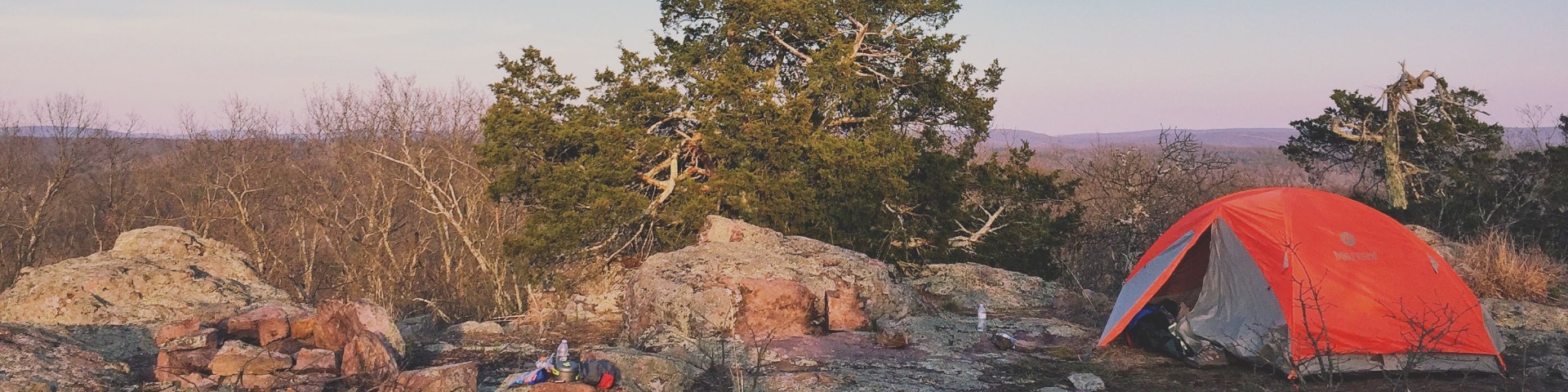
Cedar Creek Trl System


Area Status: Open
Bluff above Cedar Creek, looking over into Boone County

Cedar Creek Trail is a 36-mile trail that goes throughout the western half of the Cedar Creek Area. The trail traverses between oak hickory forests and tall grass prairie lands. The trail consists of four main sections. The trail winds on the county roads, users should beware of mixed use of vehicles and hikers.

The Southern Loop is 22-miles marked with gray diamonds. 2/3s of this trail are pasture or county roads. This loop you will be crossing Cedar Creek on the Barnett School Road Bridge. Users will cross Y Highway as they weave in and out of the Baskett Wildlife Research Area (University of Missouri). This loop connects to the Smith Creek Loop at Rutherford Bridge. It connects to Moon Loop at the far north end of the trail. It connects at Y Highway, to the east, with the Pine Ridge Section.

The Smith Creek Loop traverses 5-miles between Boydsville and Rutherford Bridge. This section is marked with orange diamonds. There are amazing vistas of the Cedar Creek from bluffs above. A section of the trail crosses Smith Creek, there is no bridge at the crossing. The loop connects into the Southern Loop and can go up to the Moon Loop on the west side. Or, you can go south and connect in to the Pine Ridge section and connect into the Southern Loop.

The Pine Ridge Section is 2.8 miles and passes through Pine Ridge Recreation Area . It connects from Y Highway on the east side of the Southern Loop up to Smith Creek Loop. You can start this section at Pine Ridge Recreation Area and hike to Dry Fork Campground. From Y highway to southern loop connection the trail is a Y shape, one segment goes into the campground and is foot traffic only, the other segment is open to horses. Please reference the map. This section is marked with grey diamonds.

The Moon Loop portion is approximately 6.2-miles in length and is named for the moon-like appearance of the area caused by soil erosion in the 1930s. The area has since been restored. This loop boasts beautiful wildflowers, much of it crosses pasture and travels along gravel roads. It is located near Columbia and can be pretty busy on a nice weekend. This section is marked with yellow diamonds. There are two stream crossings going over the Big Branch Creek, there are no bridges. It is relatively flat.

Maps and Brochures

A printable brochure is available for download.

view of the parking area at the cedar creek trailhead view of the road gate for Cedar Creek Trail at Oak Chapel Bluff above Cedar Creek, looking over into Boone County

At a Glance

Fees: There are no fees at trailheads.
Open Season: January - December
Usage: Medium
Best Season: Spring and fall; Suitable for year round use.
Restrictions: On the Trail
  • Hiking, Biking and Horseback riding is permitted.
  • No motorized vehicles are permitted.
  • No horses on the 1 mile Pine Ridge Section, use alternate route.

At the Trailheads

  • Dogs must be on a 6-foot leash in the day use area
  • No trash containers; please pack out all your trash.
  • Fireworks are prohibited.
  • Horses may not be tied directly to trees.
Closest Towns: Columbia, Ashland, Fulton
Water: Dry Fork and Pine Ridge Recreation Area trailheads
Restroom: Dry Fork and Pine Ridge Recreation Area trailheads
Operated By: USDA Forest Service
Information Center: Houston/Rolla/Cedar Creek Ranger District
Email | Phone and Address

General Information

Directions:

Trailheads are available at Pine Ridge recreation area for hikers and mountain bikers. Equestrian trailhead available at Dry Fork Campground.

Ginn Road Trailhead - 38.849337, -92.178934

  • Moon Loop

Barnes Chapel Road Trailhead - 38.861254, -92.167040

  • Moon Loop

Rutherford Bridge Trailhead

  • Smith Loop
  • Southern Loop

Pine Ridge - 38.758960, -92.142616

  • Pine Ridge

Dry Fork - 38.785827, -92.125066

  • Pine Ridge

Boydsville Road Trailhead - 38.814193, -92.111619

  • Smith Loop

County Road 354 - 38.824002, -92.137707

  • Smith Loop

Accessibility:

Pinde Ridge Recreation Area - Tables, toilet, grills, and lantern posts are accessible.


General Notes:

Safety:

  • No drinking water is not available at most trailheads or along the trail; bring what you will need, or be prepared to sterilize water you find.
  • During temperate months, be prepared for biting insects, poison ivy and high temperatures.
  • Be aware of hunting seasons.

For more safety tips visit the Safety section of the website.


Parking:

All trailheads have a registry board. This lets us know when trails are being used and how so we can better manage the trails.

Most parking areas can fit 3 vehicles.

Horses

Pine Ridge – horse trailers will not fit

All other trailheads can fit horse trailers.


Recreation Map

Map showing recreational areas. Map Information

Activities

Mountain Biking

Recreation areas with activity Mountain Biking:

The Cedar Creek Trail located southeast of Columbia offers mountain bike trails that allow riders to negotiate low ridges and tributaries of Cedar Creek, forest, and tallgrass prairie land. The trail offers approximately 36 miles of riding area. The trail offers an excellent opportunity to view over 16,500 restored acres in the Cedar Creek Ranger District and various wildlife habitats.

Dispersed Camping

Recreation areas with activity Dispersed Camping:

Dispersed camping is the term used for free camping anywhere in the National Forest OUTSIDE of a designated campground.

Dispersed camping means there are no toilets, no structures, no trash cans, no treated water, and no fire grates.

There are extra responsibilities required for this type of camp. It's a must to educate yourself before you try it, but we hope the adventure of dispersed camping in the Mark Twain National Forest calls to you!

  1. Pick a Campsite and follow the Leave No Trace Principles
  2. Camp 100 feet away from trails and water sources.
  3. Treat any water found in the area before consuming it.
  4. Human waste (Feces) must be buried at least 6 inches deep and covered.
  5. Pack out all of your garbage.

For more information on Dispersed Camping visit our dispersed camping page which has information on picking a campsite, how to protect water quality, and campfires!

Day Hiking

Recreation areas with activity Day Hiking:

The Cedar Creek Trail located southeast of Columbia offers mountain bike trails that allow riders to negotiate low ridges and tributaries of Cedar Creek, forest, and tallgrass prairie land. The trail offers approximately 36 miles of riding area. The trail offers an excellent opportunity to view over 16,500 restored acres in the Cedar Creek Ranger District and various wildlife habitats.

Backpacking

Recreation areas with activity Backpacking:

The Cedar Creek Trail located southeast of Columbia offers mountain bike trails that allow riders to negotiate low ridges and tributaries of Cedar Creek, forest, and tallgrass prairie land. The trail offers approximately 36 miles of riding area. The trail offers an excellent opportunity to view over 16,500 restored acres in the Cedar Creek Ranger District and various wildlife habitats.

Horse Riding

Recreation areas with activity Horse Riding:

Cedar Creek Trail is approximately 36 miles long and offers a great opportunity to view over 16,000 restored acres in the Cedar Creek Ranger District with various wildlife habitats. The trail meanders through the oak hickory forests and tallgrass prairies, with the equestrian trailhead located at Dry Fork Recreation Area. Access to trail can also be found on many county roads in the area.

Camping amenities at Dry Fork Recreation Area include 8 primitive camp sites each with table, fire ring, and lantern post that can accommodate up to 30 foot RV’s or smaller vehicles pulling a trailer. Other amenities include pressurized drinking water, vault toilets, picnic area, and hitching posts. No camping fees, but donations are encouraged.

No horses allowed on Pine Ridge Section of Cedar Creek Trail, alternative route available.

Viewing Wildlife

Recreation areas with activity Viewing Wildlife:

The Cedar Creek Trail provides multiple avenues to experience nature in its natural setting either by hiking, mountain biking, or horseback riding. Prior to 1940, the land was exceedingly cultivated by private land owners resulting in depleted and eroded soils.

Since 1953, the U.S. Forest Service has been managing this land and now Cedar Creek Trail offers a variety of wildlife habitats and plants species that call the oak-hickory forests and tallgrass prairies their home.

Plant and wildlife observers can now enjoy activities such as bird watching, rock hounding, and photography from the low ridges and tributaries of Cedar Creek, to the scenic bluffs overlooking the area.

The ultimate wildlife viewing experience is watching animals in their habitat.  Here are some helpful tips to become a wildlife friendly viewer:

  • Use the right tools - A field guide, a pair of binoculars and a camera.  Wear clothing that is appropriate for the season and activity.
  • Watch at dawn and dusk - This is the time when most wildlife species are active enough to view.
  • Keep your distance - Maintain a distance that is comfortable for the wildlife.
  • Stay quiet - Move slowly and quietly to increase your chances of viewing wildlife, and to avoid stressing the animals you wish to watch.
  • Do not feed the wildlife - There is plenty of food availale in the wild.  Human food can cause digestive problems, provide improper nutrition, and even kill an animal. 

An online version of the Missouri Wildlife Viewing Guide is available on their website.

Viewing Plants

Recreation areas with activity Viewing Plants:

The Cedar Creek Trail provides multiple avenues to experience nature in its natural setting either by hiking, mountain biking, or horseback riding. Prior to 1940, the land was exceedingly cultivated by private land owners resulting in depleted and eroded soils. Since 1953, the U.S. Forest Service has been managing this land and now Cedar Creek Trail offers a variety of wildlife habitats and plants species that call the oak-hickory forests and tallgrass prairies their home. Plant and wildlife observers can now enjoy activities such as bird watching, rock hounding, and photography from the low ridges and tributaries of Cedar Creek, to the scenic bluffs overlooking the area.

Within this wide and varied landscape there exists a diverse array of plants. Of the roughly 2800 species of plant in Missouri, about two-thirds can be found on the Forest. While most can be found commonly throughout the Forest, less common species can be found in specific natural communities such as calcareous fens, acid seeps, and glades (limestone, dolomite and igneous).

What to look for

Viewing Scenery

Recreation areas with activity Viewing Scenery:

The Cedar Creek Trail provides multiple avenues to experience nature in its natural setting either by hiking, mountain biking, or horseback riding. Prior to 1940, the land was exceedingly cultivated by private land owners resulting in depleted and eroded soils.

Since 1953, the U.S. Forest Service has been managing this land and now Cedar Creek Trail offers a variety of wildlife habitats and plants species that call the oak-hickory forests and tallgrass prairies their home.

Plant and wildlife observers can now enjoy activities such as bird watching, rock hounding, and photography from the low ridges and tributaries of Cedar Creek, to the scenic bluffs overlooking the area.

Related Information

Recreation Areas

Recreation Activities

Location

 
  Area/Length : 
36 miles

  Latitude : 
38.775111

  Longitude : 
-92.185072