
Official websites use .gov
A .gov
website belongs to an official government organization in the
United States.
Secure .gov websites use HTTPS
A lock
(
) or https:// means you've safely
connected to the .gov website. Share sensitive information only
on official, secure websites.


Bruno's Run Trail
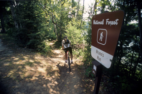
The Bruno’s Run Trail offers a 9 mile (14.48 km) loop ideal for non-motorized uses. Although the trail is not groomed in winter, it does offer a suitable outing for hikers, bikers, and horseback riders who prefer to break their own way. In keeping with agency interim direction, non-motorized trails are not open to eBikes (https://www.fs.usda.gov/visit/e-bikes).
The trail winds its way past a host of small lakes etched in this relatively young glacial plain, taking users over gently rolling country. Further along, the trail runs over foothills, along overlooks and through valleys. The many lakes and streams in the area as well as a variety of trees and other plants make it likely that those traveling the trail will spot wildlife or tracks. If you are alert, you are sure to have an enjoyable outing. Be careful with fire.
Trail Safety: Please keep in mind that this is a multi-purpose trail.
Users should maintain control of their speed at all times and approach turns in anticipation of someone around the bend. The trail is not groomed in the winter, and some areas may be icy or uneven, and you may encounter limbs or trees across the trail. Link to Bruno's Run Trail map.
At a Glance
| Open Season: | January - December |
|---|
General Information
Directions:Located about 11 miles south of M-28, Bruno’s Run Trail may be reached from the north or the south via Forest Highway 13. The trail may be accessed from both Widewaters and Pete’s Lake campgrounds as well as from Forest Highway 13 at Moccasin Lake and Forest Road 2173 at Grassy Lake. Limited parking is available at each site.
Activities
Mountain Biking
9.25 mile loop trail. In keeping with agency interim direction, this non-motorized trail is not open to eBikes (https://www.fs.usda.gov/visit/e-bikes).
TRAIL SEGMENTS:
Moccasin Lake to Pete’s Lake Campground (.92mi/1.53km): Beginning at a scenic point overlooking Moccasin Lake, the trail moves east from Forest Highway 13 to the campground north of Pete’s Lake.
Pete’s Lake to McKeever Lake (1.80mi/3.0km): The trail winds between Pete’s Lake and Grassy Lake, generally following a route parallel to Forest Road 2173.
McKeever Lake to FR 2258 (3.09mi/5.15km): a small bridge allows crossing of a stream south of McKeever Lake. Rolling hills on the western part of this segment provide some of the most scenic terrain on the trail. Dipper Lake and Wedge Lake may be viewed from overlooks along the way.
Forest Road 2258 to Widewaters Campground (1.64mi/2.7km): After crossing Forest Highway 13 and the Indian Wild & Scenic River, the trail runs northwest to Fish Lake, where a bridge provides a stream crossing near the campground.
Widewaters Campground to Moccasin Lake (1.66 mi/2.77km): This short segment includes rolling country that travels over an old logging grade and through a dense stand of mature hemlock called the “Hemlock Cathedral”. The round-trip ends at the trail access point at Moccasin Lake.
| Status: | Open |
|---|---|
| Difficulty Level: | Intermediate |
Day Hiking
9.25 mile loop trail
TRAIL SEGMENTS:
Moccasin Lake to Pete’s Lake Campground (.92mi/1.53km): Beginning at a scenic point overlooking Moccasin Lake, the trail moves east from Forest Highway 13 to the campground north of Pete’s Lake.
Pete’s Lake to McKeever Lake (1.80mi/3.0km): The trail winds between Pete’s Lake and Grassy Lake, generally following a route parallel to Forest Road 2173.
McKeever Lake to FR 2258 (3.09mi/5.15km): a small bridge allows crossing of a stream south of McKeever Lake. Rolling hills on the western part of this segment provide some of the most scenic terrain on the trail. Dipper Lake and Wedge Lake may be viewed from overlooks along the way.
Forest Road 2258 to Widewaters Campground (1.64mi/2.7km): After crossing Forest Highway 13 and the Indian Wild & Scenic River, the trail runs northwest to Fish Lake, where a bridge provides a stream crossing near the campground.
Widewaters Campground to Moccasin Lake (1.66 mi/2.77km): This short segment includes rolling country that travels over an old logging grade and through a dense stand of mature hemlock called the “Hemlock Cathedral”. The round-trip ends at the trail access point at Moccasin Lake.
| Status: | Open |
|---|---|
| Difficulty Level: | Intermediate |
Horse Riding
9.25 mile loop trail
TRAIL SEGMENTS:
Moccasin Lake to Pete’s Lake Campground (.92mi/1.53km): Beginning at a scenic point overlooking Moccasin Lake, the trail moves east from Forest Highway 13 to the campground north of Pete’s Lake.
Pete’s Lake to McKeever Lake (1.80mi/3.0km): The trail winds between Pete’s Lake and Grassy Lake, generally following a route parallel to Forest Road 2173.
McKeever Lake to FR 2258 (3.09mi/5.15km): a small bridge allows crossing of a stream south of McKeever Lake. Rolling hills on the western part of this segment provide some of the most scenic terrain on the trail. Dipper Lake and Wedge Lake may be viewed from overlooks along the way.
Forest Road 2258 to Widewaters Campground (1.64mi/2.7km): After crossing Forest Highway 13 and the Indian Wild & Scenic River, the trail runs northwest to Fish Lake, where a bridge provides a stream crossing near the campground.
Widewaters Campground to Moccasin Lake (1.66 mi/2.77km): This short segment includes rolling country that travels over an old logging grade and through a dense stand of mature hemlock called the “Hemlock Cathedral”. The round-trip ends at the trail access point at Moccasin Lake.
XC Skiing/Snowshoeing
9.25 mile loop trail
TRAIL SEGMENTS:
Moccasin Lake to Pete’s Lake Campground (.92mi/1.53km): Beginning at a scenic point overlooking Moccasin Lake, the trail moves east from Forest Highway 13 to the campground north of Pete’s Lake.
Pete’s Lake to McKeever Lake (1.80mi/3.0km): The trail winds between Pete’s Lake and Grassy Lake, generally following a route parallel to Forest Road 2173.
McKeever Lake to FR 2258 (3.09mi/5.15km): a small bridge allows crossing of a stream south of McKeever Lake. Rolling hills on the western part of this segment provide some of the most scenic terrain on the trail. Dipper Lake and Wedge Lake may be viewed from overlooks along the way.
Forest Road 2258 to Widewaters Campground (1.64mi/2.7km): After crossing Forest Highway 13 and the Indian Wild & Scenic River, the trail runs northwest to Fish Lake, where a bridge provides a stream crossing near the campground.
Widewaters Campground to Moccasin Lake (1.66 mi/2.77km): This short segment includes rolling country that travels over an old logging grade and through a dense stand of mature hemlock called the “Hemlock Cathedral”. The round-trip ends at the trail access point at Moccasin Lake.
| Status: | Open |
|---|---|
| Difficulty Level: | Intermediate |
Related Information
Highlights
- Check out videos from around the Forest
- eBikes

Please note that our biking trails are designated "non-motorized." In keeping with agency direction, non-motorized trails are not open to eBikes. - How to Live with Black Bears

- Hiawatha Tour App
Use Hiawatha's OnCell app on your personal mobile device to take self-guided tours of natural and heritage sites. - Recreation, Heritage & Wilderness Management
National Forests are managed for multiple uses. Learn how these resources contribute!
Location


