Official websites use .gov
A .gov
website belongs to an official government organization in the
United States.
Secure .gov websites use HTTPS
A lock
(
) or https:// means you've safely
connected to the .gov website. Share sensitive information only
on official, secure websites.


Trails #180 & #180D Silver Star & Summit
This 5 mile trail gradually ascends to an old roadbed, passing just west of Silver Star Mountain.
From the Silver Star Trailhead the trail heads south. After passing through wildflower covered slopes and huckleberry thickets, the trail intersects Ed's Trail #180A. Chinook Trail #180B, Sturgeon Rock Trail #180C, and Bluff Mountain Trail #172 all are reached in less than 2 miles from the trailhead. Just beyond the Bluff Mountain Trail, Silver Star Summit Trail #180D leads 0.25 mile to the summit of Silver Star Mountain.
Indian Pits Trail #180E and Pyramid Rock Trail #180F branch from the Silver Star Trail south of Silver Star Mountain before descending to the trailhead at Department of Natural Resources Road W-1200.
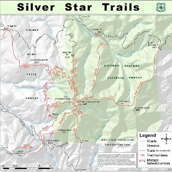
MAP: Silver Star/Grouse Vista Trail vicinity map via Department of Natural Resources showing south & west side access.
At a Glance
| Current Conditions: | 03/19/2024: Both trails are open. |
|---|---|
| Open Season: | Summer - Fall |
| Usage: | Medium |
| Restrictions: | Motorized use prohibited. |
| Closest Towns: | Yacolt, WA; Vancouver, WA |
| Operated By: | Forest Service |
| Information Center: | Mount St. Helens National Volcanic Monument Administrative Headquarters (360) 449-7800 |
General Information
Directions:North: Silver Star Trailhead - The road to this trailhead is very rough.
Grouse Vista Trailhead (South): From Vancouver Washington take Highway 14 east to the town of Washougal. At milepost 16 turn left on Washougal River Road. At just under seven miles on Washougal River Road turn left onto NE Hughes Road. Stay on this obvious main road for 3.2 miles (It will become NE 392nd then NE 28th then NE Miller Road, then NE 39th without you making any turns) then turn left on NE 412th, also called Skamania Mines Road. Shortly you will come to a fork, stay right to stay on Skamania Mines Road. After 2.8 miles turn left onto DNR road 1200 for 5.7 miles as it turns increasingly rough to end at the trailhead. Most cars will do fine on this road, although you may have to go slow through some rough patches.
(This trailhead requires a Washington Discover Pass - not available on-site)
General Notes:
Trail Vicinity Map: