
Official websites use .gov
A .gov
website belongs to an official government organization in the
United States.
Secure .gov websites use HTTPS
A lock
(
) or https:// means you've safely
connected to the .gov website. Share sensitive information only
on official, secure websites.


Mount St. Helens area
Visit Mount St. Helens from any direction! View areas below for current information.
-
Mount St. Helens West

From I-5, drive into the heart of the blast zone. Spectacular crater views, visitor centers, picnic areas and hikes await. Learn what's open along State Route 504!
-
Mount St. Helens East

This summer and fall route offers views of the crater and Spirit Lake, interpretive sites, and easy or rugged hiking.
-
Mount St. Helens South

Lava flows, waterfalls, caves, and lush forest abound. Plenty of year-round recreation options.
-
Mount Margaret Backcountry

Rugged, steep trails and amazing landscapes typify the Mt. Margaret Backcountry. Permits required for overnight camping.
At a Glance
| Current Conditions: | Always make sure to check road conditions before your trip. View the list of key roads in the Mount St. Helens area and select the link to view current road conditions:
|
|---|---|
| Operational Hours: | View current office hours |
| Reservations: | Teachers Corner: Field trips to Mount St. Helens start here |
| Fees: |
|
| Permit Info: |
|
| Information Center: |
|
General Information
Directions:Mount St. Helens Science and Learning Center at Coldwater: From Castle Rock, WA take State Route 504 east for 42 miles to the Science and Learning Center.
Johnston Ridge Observatory: From Castle Rock, WA take State Route 504 east for 52 miles to Johnston Ridge Observatory at the end of State Route 504. (CLOSED 2024)
Windy Ridge Interpretive Site: From Randle, WA travel south on State Route (SR) 131 until the road forks (1 mile). Stay to the right on State Route 131 which becomes Forest Road 25. Travel south on Forest Road 25 for 19 miles to Forest Road 99. Turn right on Forest Road 99 and drive 16 miles until it terminates at Windy Ridge.
Vicinity map showing key site locations: Mount St. Helens National Volcanic Monument (.pdf)
General Notes:
-
Mount St. Helens 1980 Eruption & Aftermath

On the morning of May 18, 1980, a magnitude 5.1 earthquake triggered the collapse of the summit and north flank of Mount St. Helens and formed the largest landslide in recorded history. In 1982 Congress designated the 110,000-acre Mount St. Helens National Volcanic Monument. The following decades have offered insight into the biological recovery of ravaged landscapes.
Activities
Mountain Biking
Areas for Mountain Biking at Mount St. Helens area
- Mount St. Helens East: Forest Roads 25 & 99
- Trail #213 Green River
- Trail #213A Vanson Ridge
- Trail #216D: Abraham
- Trail #217 Goat Mountain
- Trailhead: Goat Mountain
- Trail #217A Vanson Peak
- Trail #218 Tumwater
- Mount St. Helens South: Forest Roads 83 & 81
- Trail #129 Huffman Peak
- Trail #130 Siouxon
- Trailhead: Siouxon
- Trail #130A Chinook Creek
- Trail #156 Wildcat
- Trail #180B Chinook
- Trail #180C Sturgeon Rock
- Trail #180F Pyramid Rock/Grouse Vista
- Trail #204 Cinnamon
- Trail #216A Ptarmigan
- Trail #216B June Lake
- Trail #225 Smith Creek
- Trailhead: Smith Creek (Road 99)
- Trail #234 Ape Canyon
- Trail #237 Blue Lake
- Trail #238 Toutle
- Trail #238A Butte Camp
- Trail #240 Sheep Canyon
- Trail #242 Fossil
- Trailhead: Blue Lake (Mt St Helens)
- Trails #180 & #180D Silver Star & Summit
- Mount St. Helens West: State Highway 504
- Trail #207 Truman (Willow Springs #207A)
- Trail #230A South Coldwater
- Trail #139 East Fork
- Trail #191 Zig Zag Lake
- Trail #216 Loowit
- Loowit #216- Butte Camp to Ptarmigan Trail
- Loowit #216- Castle Ridge to Sheep Canyon Trail
- Loowit #216- Ptarmigan to June Lake Trail
- Loowit Trail #216- Ape Canyon to Windy Trail
- Loowit Trail #216- June Lake to Ape Canyon Trail
Campground Camping
Areas for Campground Camping at Mount St. Helens area
Mountain Climbing
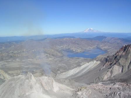 Climb and explore one of the best lunch spots in the Northwest, but, you will have to work for it! A 4 to 6 hour climb up will reward you with spectacular panoramic views from the rim of Mount St. Helens. On a clear day you can see Spirit Lake, the crater, Mount Rainer, Mount Adams and Mount Hood.
Review all information about Climbing Mount St. Helens.
| Reservation required?: | Y |
|---|---|
| Permit required?: | Y |
Areas for Mountain Climbing at Mount St. Helens area
Day Hiking
Areas for Day Hiking at Mount St. Helens area
- Mount Margaret Backcountry
- Mount St. Helens East: Forest Roads 25 & 99
- Trail #1: Boundary- Norway Pass TH to Norway Pass
- Trail #1: Boundary- Norway Pass to Elk Pass
- Trail #210 Meta Lake
- Meta Lake Interpretive Site
- Trail #213 Green River
- Trail #213A Vanson Ridge
- Trail #216D: Abraham
- Trail #216E Windy
- Trail #217 Goat Mountain
- Trailhead: Goat Mountain
- Trail #217A Vanson Peak
- Trail #222 Ryan Lake
- Trail #224 Harmony
- Harmony Falls Viewpoint
- Trail #227 Independence Pass
- Trailhead: Independence Pass
- Trail #227A Independence Ridge
- Trailhead: Norway Pass
- Windy Ridge Interpretive Site
- Mount St. Helens South: Forest Roads 83 & 81
- Ape Cave Interpretive Site
- Campground: Sunset Falls Campground and Day Use
- Horse Camp: Kalama
- Lava Canyon Interpretive Site
- Trail #129 Huffman Peak
- Trail #130 Siouxon
- Trailhead: Siouxon
- Trail #130A Chinook Creek
- Trail #140 Horseshoe Ridge
- Trail #156 Wildcat
- Trail #172 Bluff Mountain
- Trail #174 Sunset Falls
- Trail #175 Starway
- Trail #180A Ed's
- Trail #180B Chinook
- Trail #180C Sturgeon Rock
- Trail #180E Indian Pits
- Trail #180F Pyramid Rock/Grouse Vista
- Trail #184 Lava Canyon
- Trail #204 Cinnamon
- Trail #216A Ptarmigan
- Trail #216B June Lake
- Trailhead: June Lake
- Trail #225 Smith Creek
- Trailhead: Smith Creek (Road 8322)
- Trailhead: Smith Creek (Road 99)
- Trail #233 Trail of Two Forests
- Trail #234 Ape Canyon
- Trailhead: Ape Canyon
- Trail #237 Blue Lake
- Trail #238 Toutle
- Trail #238A Butte Camp
- Trail #240 Sheep Canyon
- Trail #242 Fossil
- Trailhead: Blue Lake (Mt St Helens)
- Trails #180 & #180D Silver Star & Summit
- Trailhead: Silver Star
- Trailhead: Climbers Bivouac
- Mount St. Helens West: State Highway 504
- Johnston Ridge Observatory
- Site: Coldwater Lake Picnic and Boating Area
- Trail #246 Birth of a Lake
- Trail #1: Boundary- Hummocks to Johnston Ridge
- Trail #1E Harry's Ridge
- Trail #201 Eruption
- Trail #207 Truman (Willow Springs #207A)
- Trail #211 Lakes
- Trail #216G Castle Ridge/Trail #221 Castle Lake
- Trail #229 Hummocks
- Trail #230A South Coldwater
- Trailhead: South Coldwater
- Trail #232 Winds of Change
- Trail #139 East Fork
- Trail #173 Summit Springs
- Trail #191 Zig Zag Lake
- Trail #205 Goat Creek
- Trail #216 Loowit
- Loowit Trail #216- Ape Canyon to Windy Trail
- Loowit Trail #216- June Lake to Ape Canyon Trail
Backpacking
Areas for Backpacking at Mount St. Helens area
- Mount Margaret Backcountry
- Mount St. Helens East: Forest Roads 25 & 99
- Trail #1: Boundary- Norway Pass TH to Norway Pass
- Trail #1: Boundary- Norway Pass to Elk Pass
- Trail #218 Tumwater
- Trailhead: Norway Pass
- Windy Ridge Interpretive Site
- Mount St. Helens South: Forest Roads 83 & 81
- Horse Camp: Kalama
- Trail #129 Huffman Peak
- Trail #130 Siouxon
- Trail #140 Horseshoe Ridge
- Trail #156 Wildcat
- Trail #172 Bluff Mountain
- Trail #175 Starway
- Trail #180B Chinook
- Trail #180C Sturgeon Rock
- Trail #180F Pyramid Rock/Grouse Vista
- Trail #204 Cinnamon
- Trail #216A Ptarmigan
- Trail #225 Smith Creek
- Trail #234 Ape Canyon
- Trail #237 Blue Lake
- Trail #238 Toutle
- Trail #238A Butte Camp
- Trail #240 Sheep Canyon
- Trail #242 Fossil
- Trails #180 & #180D Silver Star & Summit
- Mount St. Helens West: State Highway 504
- Trail #1: Boundary- Truman #207 to Norway Pass
- Trail #207 Truman (Willow Springs #207A)
- Trail #230 Coldwater
- Trail #139 East Fork
- Trail #173 Summit Springs
- Trail #216 Loowit
- Loowit #216- Butte Camp to Ptarmigan Trail
- Loowit #216- Castle Ridge to Sheep Canyon Trail
- Loowit #216- Ptarmigan to June Lake Trail
- Loowit #216- Sheep Canyon to Butte Camp Trail
- Loowit Trail #216- June Lake to Ape Canyon Trail
- Loowit Trail #216- Windy to Castle Ridge Trail
Horse Camping
Areas for Horse Camping at Mount St. Helens area
Horse Riding
Areas for Horse Riding at Mount St. Helens area
- Mount St. Helens East: Forest Roads 25 & 99
- Trail #213 Green River
- Trail #213A Vanson Ridge
- Trail #217 Goat Mountain
- Trailhead: Goat Mountain
- Trail #217A Vanson Peak
- Trail #218 Tumwater
- Mount St. Helens South: Forest Roads 83 & 81
- Trail #129 Huffman Peak
- Trail #130 Siouxon
- Trailhead: Siouxon
- Trail #130A Chinook Creek
- Trail #156 Wildcat
- Trail #172 Bluff Mountain
- Trail #175 Starway
- Trail #180B Chinook
- Trail #180C Sturgeon Rock
- Trail #180F Pyramid Rock/Grouse Vista
- Trail #204 Cinnamon
- Trail #237 Blue Lake
- Trail #238 Toutle
- Trail #240 Sheep Canyon
- Trail #242 Fossil
- Trailhead: Blue Lake (Mt St Helens)
- Trails #180 & #180D Silver Star & Summit
- Trail #139 East Fork
- Trail #173 Summit Springs
- Trail #191 Zig Zag Lake
- Trail #205 Goat Creek
OHV Trail Riding
Areas for OHV Trail Riding at Mount St. Helens area
XC Skiing/Snowshoeing
Areas for XC Skiing/Snowshoeing at Mount St. Helens area
- Mount St. Helens South: Forest Roads 83 & 81
- Sno-Park: Cougar
- Sno-Park: Marble Mountain
- Sno-Park: Trail of Two Forests
Snowmobiling
Areas for Snowmobiling at Mount St. Helens area