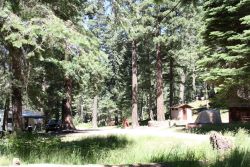
Shannon Campground is small and tucked away along the upper reaches of Marijilda Creek, a pleasant little brook that winds through a setting of tall trees and green grass. Campsites are shaded under mature Engelmann spruce and Douglas-fir. Two three-sided wood shelters of the type originally developed in the Adirondack Mountains of New York add to the historic atmosphere of this campground.
The Arcadia Trail, which leads down the mountain to Arcadia Campground, has been designated a National Recreation Trail. A one-mile spur leads from this trail to the top of Heliograph Peak, a vantage point with a history as well as a view. This 10,022-foot vantage point once served as a location for signal mirrors used to communicate messages during the Apache Wars of the late 1880s. Today you’ll find a Forest Service lookout tower on the mountaintop as well as some of the most panoramic views in southeastern Arizona.
Note: Black bear area. Store and dispose of all food in bear-proof containers and trash bins, or keep it locked in your vehicle with windows all the way up.
At a Glance
| Reservations: | This is a first-come, first-served campground. Reservations are not accepted. |
|---|---|
| Area Amenities: | Tent camping, Fee charged for some activities, Picnic tables, Toilets, Parking |
| Fees: | Single site: $15. With Golden Age/Access or Interagency Senior/Access pass $7.50. Payable with cash or check. |
| Usage: | Light-Medium |
| Restrictions: | Vehicle restrictions: Vehicles (including trailers) longer than 22 feet are not recommended because of the difficulty of negotiating the switchbacks on AZ 366. Campground restrictions: Pack and saddle stock are not permitted in campground. Limit 2 vehicles and 10 persons per site. 14 day stay limit. |
| Closest Towns: | Safford, AZ |
| Information Center: | Safford Ranger District 928-428-4150 |
General Information
Directions: From Safford drive south 8 miles on US 191 to AZ 366. Turn right (southwest) onto 366 and drive 21.8 miles to the campground entrance on the right side of the road. Check local road conditions during winter months.Activities
Campground Camping
| No. of Sites | 11 |
| Sleeping Shelter | Two Adirondack-style shelters. |
Day Hiking
Backpacking
Amenities
| Picnic tables: | Yes |
|---|---|
| Tent camping: | Yes |
| Fee charged for some activities: | Yes |
| Parking: | Yes |
| Toilets: | Yes |

