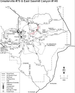
East Sawmill Canyon #146
The Greaterville Trail, combined with the East Sawmill Canyon Trail, provides access from the northeast to Florida Saddle, one of the major trail crossroads in the Santa Rita Range. This saddle marks the beginning of the Crest Trail #144 that leads to the summit of Mt. Wrightson. The Greaterville and East Sawmill Canyon trails pass through an area of rugged, scrub oak-clad ridges and forested canyons that slope gradually toward the Santa Ritas. Both offer views to the east, of the Whetstones and Mustangs, as well as to the west of Mt. Wrightson and the Santa Rita Crest. Closer at hand, ponderosa pines, alligator junipers and Emory, white and silverleaf oaks make up most of the scenery. This area is good wildlife habitat. There are healthy populations of Coues white-tailed deer in the area, and if your eye is sharp enough to see them before they flush, you might spot some scaled quail or Montezuma quail. From the western terminus of East Sawmill Canyon Trail you can head north into Florida Canyon, south and east along Cave Creek Canyon or continue along the Crest Trail to the top of the Santa Ritas.
At a Glance
| Usage: | Light |
|---|---|
| Restrictions: | Motorized and mechanical vehicles and equipment, including mountain bikes, are not permitted in Wilderness. |
| Operated By: | Nogales Ranger District |
General Information
Directions:East Sawmill Canyon Trail: 21 miles south of Interstate 10 and 4 miles north of Sonoita on AZ 83, turn west onto Gardner Canyon Road (FR 92). Keep to the left at three-quarters of a mile and take the right fork at about 4 miles. Go around the Apache Springs Ranch then continue past the Arizona Trail trailhead, thru the creek crossing, to FR 4085 at the cattle guard. Turn north on FR 4085. Continue to FR 4084 Turn west on FR 4084. Follow FR 4084 to the trailhead at Aliso Spring. The last 5 miles or so of this road may require a high clearance, 4-wheel drive vehicle.
Note: FR 165 past the trailhead is scheduled to be closed (OAR only) as part of Travel Management


