
Official websites use .gov
A .gov
website belongs to an official government organization in the
United States.
Secure .gov websites use HTTPS
A lock
(
) or https:// means you've safely
connected to the .gov website. Share sensitive information only
on official, secure websites.


Cottonwood #233
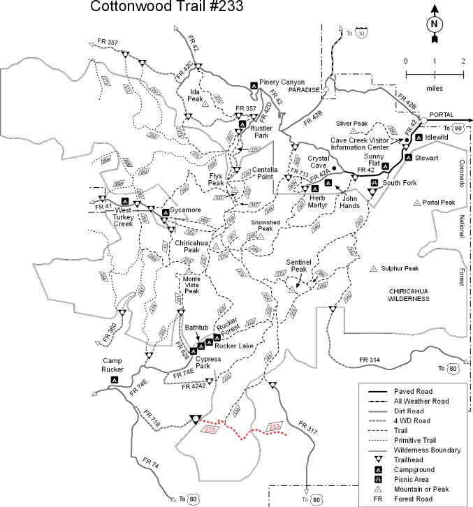 This primitive trail leads into an area of red-rock bluffs and wide canyons. Low peaks with sheer cliff faces and scrub-covered slopes define the horizon, as this roughly defined route snakes along intermittent watercourses and up and over the manzanita- and oak-clad ridges that separate them. Some of the climbs are steep here and the trail can be hard to follow, but views that stretch into Mexico are the reward for your diligence and effort. Remember, this is a primitive trail, which means that the level of maintenance is low. Come prepared to be responsible for finding your own way and be ready to take some time to do it. Because this area is relatively low in elevation, exposed and south facing slopes can be quite hot. Since natural sources of water are unreliable, be sure to bring plenty of your own. This is an area that was used heavily in the mid 1800’s by the U. S. Army during their campaign against Geronimo, but it’s doubtful that you will see any evidence of that aspect of its history. The Cottonwood Trail dead ends at private land, so through hikes are not possible.
At a Glance
| Usage: | Light |
|---|---|
| Operated By: | Douglas Ranger District |
| Information Center: | Douglas Ranger District 520-364-3468 |
General Information
Directions: From Douglas, take Leslie Canyon Road north to Rucker Canyon. Stay on the main road, which will become FR 74. Follow this road to FR 718 and turn left to the trail at the end of the road. There is no public access on the east end. These roads are rough and dusty and may be muddy and slick when wet. There is flash flood danger at water crossings following summer and winter storms.Activities
Day Hiking
Cross-country route, remote setting, primitive trails, good views. This trail is maintained in a primitive condition. Using it safely requires appropriate skills and equipment. 4.2 miles of the Cottonwood Trail are within the Chiricahua Wilderness. USGS Map(s): Swede Peak| Elevation desc | 5,600 - 7,400 feet |
| Difficulty Level: | More Difficult |
|---|