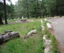
Riggs Flat Campground

The main attraction at Riggs Flat Campground (Map) is Riggs Flat Lake. Some come to fish in it, some to boat on it, and some just to enjoy the reflective beauty this small (11 acre) lake adds to such a scenic area. The dam was financed by the Arizona Game and Fish Department in 1957 to provide trout fishing for forest recreationists. Information about stocking Riggs Lake is available from Arizona Game and Fish Department.
Note: Black bear area. Store and dispose of all food in bear-proof containers and trash bins, or keep it locked in your vehicle with windows all the way up.
At a Glance
| Reservations: | This is a first-come, first-served campground. Reservations are not accepted for single sites. Reserve the Riggs Lake Group site are at www.recreation.gov. |
|---|---|
| Area Amenities: | Boat ramp, Tent camping, Camping trailer, Fee charged for some activities, Picnic tables, Toilets, Drinking water, Parking |
| Fees: | Twenty-six campsites. Single site: $20. With Golden Age/Access or Interagency Senior/Access pass $10. Payable with cash or check on site. |
| Permit Info: | A valid Arizona fishing license is required to fish in Riggs Lake. |
| Open Season: | April 15 - November 14 |
| Usage: | Medium-Heavy |
| Restrictions: | Vehicle Restrictions: Vehicles (including trailers) longer than 22 feet are not recommended because of the difficulty of negotiating the switchbacks on AZ 366. This trailhead is not accessible by vehicle from November 15 to April 15 when the Swift Trail is closed for the winter. Early or late snow may extend the inaccessible season. Boat Restrictions: Boats permitted on the lake may be powered by no more than a single electric trolling motor. Campground Restrictions: Pack and saddle stock are not permitted in campground. Limit 2 vehicles and 10 persons per site. 14 day stay limit. |
| Closest Towns: | Safford, AZ |
| Information Center: | Safford Ranger District (928) 428-4150 |
General Information
Directions:From Safford, Arizona: Drive south 8 miles on US 191 to AZ 366/Swift Trail. Turn right (southwest) onto 366 and drive 29 miles to the Columbine Visitor Center. Continue along National Forest Service (NFS) Roads 803 and 287 for about 5 miles to the campground.
From Tucson, Arizona: Take I-10 east for 90 miles. Take exit 352 for US 191, and turn left toward Safford. Drive 26.3 miles north and turn left on AZ 366/Swift Trail. Drive 29 miles to the Columbine Visitor Center and then continue along National Forest Service (NFS) Roads 803 and 287 for about 5 miles to the campground.
Activities
Campground Camping
Trout fishing. Cool mountain weather. Great scenery/nearby overlook. Watchable wildlife. Hiking trails. RV’s up to 22' and vehicles with trailers less than 21' are recommended. Longer vehicles have difficulty negotiating the switchbacks on the road up the mountain (AZ 366). Tables and fire grills.
| No. of Sites | 31 |
Group Camping
| No. of Sites | 1 |
| Fire Information | Tables and fire grills |
Amenities
| Camping trailer: | Less than 22 feet total |
|---|---|
| Picnic tables: | Yes |
| Tent camping: | Yes |
| Parking: | Yes |
| Toilets: | Yes |
| Fee charged for some activities: | Yes |
| Boat ramp: | Yes |
| Drinking water: | Yes |

