
Official websites use .gov
A .gov
website belongs to an official government organization in the
United States.
Secure .gov websites use HTTPS
A lock
(
) or https:// means you've safely
connected to the .gov website. Share sensitive information only
on official, secure websites.


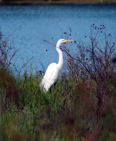
Dyar Pasture Recreation Area

This 60-acre freshwater wetland was originally a cooperative project with the U.S. Forest Service, Georgia DNR, Georgia Power and Ducks Unlimited. Dyar Pasture is a bird sanctuary and a birders paradise. Outfitted with a dike and water control system to control water levels, the management of this area enables a healthy and sustainable waterfowl habitat necessary for the continued survival of this wetland ecosystem. The area has picnicking and fishing opportunities, a boat launch with access to the Oconee River and Lake Oconee and a short hiking trail, making Dyar Pasture a fantastic place for a day of birding and appreciating a wetland habitat.
Photos of the area...
Download the Dyar Pasture Brochure. Includes a site map and a plant and animal check list along with other cool information.


At a Glance
| Current Conditions: | Open sunrise to sunset |
|---|---|
| Operational Hours: |
Day use hours Sunrise to Sunset |
| Reservations: | Reservations are not required. Occupancy of sites are on a first come, first serve basis. |
| Rentals & Guides: | None |
| Area Amenities: | Boat ramp, Toilets, Parking |
| Fees: | Boat Launch and Wildlife Viewing Facilities: $5/vehicle/day Pay your day use recreation fees and purchase the yearly Chattahoochee-Oconee Forest Pass online through recreation.gov. |
| Permit Info: | Georgia fishing license and valid boat registration required. Click here for a link to GA Department of Natural Resourses! |
| Open Season: | Year round |
| Best Season: | July to December |
| Restrictions: | Although this is a Wildlife Management Area, there is absolutely NO HUNTING allowed. No Fireworks on the National Forest! Possessing, discharging or using any kind of fireworks or other pyrotecnic or explosive device. 36 CFR 261.52 (f) |
| Closest Towns: | Dyar Pasture is 12.5 miles north east of Madison, GA. |
| Water: | Not available |
| Restroom: | Vault toilet |
| Passes: | The Interagency, Senior and Access Passes and the Golden Age Passports are accepted. These passes entitle the pass holder to a 50% discount on camping fees. Click here for detailed information on passes! |
| Information Center: | Please call the Oconee Ranger District at 706-485-7110- Office Hours are Monday-Friday 08:00 a.m. to 12:00 p.m. and 1:00 p.m. to 4:30p.m. excluding holidays |
General Information
Directions:From Greensboro GA, take US 278 west for eight miles. Turn right onto Greshamville Rd. Turn right onto Copeland Rd.
Travel approximately 2.5 miles and turn right onto a dirt road through a pasture to the Dyar Pasture Waterfowl Conservation Area.
Parking:
Parking is available for vehicles and boat trailers.
Activities
River and Stream Fishing
The Boat ramp at Dyars Pasture allows access to the Oconee River at it's most southern point before it feeds into Lake Oconee. This is a popular location for those people who enjoy fishing in a river setting.
| Status: | Open |
|---|---|
| Reservation info: | None required |
| Best Season: | Spring |
| Hours of Operation: | Sunrise to sunset |
Viewing Wildlife
This bird sanctuary is great for birding enthusiasts. Birds often seen here include Wood Storks, waders, Cliff Swallows, ducks and various other shorebirds. However, if the summer has had lots of rain, then the water may be too high for waders and they will be hard to spot.
| Best Season: | The best time of year for birding here is July - December |
|---|
Viewing Scenery
Wildlife Viewing Trail - Leads from parking to viewing platform, 0.25 mileBoating - Motorized
The boat launch provides access to the Oconee River and Lake Oconee.
| Launch Ramps | Boat Launch |
Amenities
| Parking: | For vehicles and trailers |
|---|---|
| Toilets: | vault toilet |
| Boat ramp: | single paved ramp |