
Official websites use .gov
A .gov
website belongs to an official government organization in the
United States.
Secure .gov websites use HTTPS
A lock
(
) or https:// means you've safely
connected to the .gov website. Share sensitive information only
on official, secure websites.


Long Canyon Trail No. 122
Wide and nearly level, Long Canyon Trail provides easy access into Sedona's scenic red rock backcountry. For the first mile or so, the route follows an old jeep trail up an ephemeral streambed. Though this drainage is usually dry, it still supports a community of riparian or water-loving vegetation. Along the trail you'll even find a number of cypress trees, Arizona cypress, which are easily recognizable by their shaggy bark and round, gum ball-size seeds.
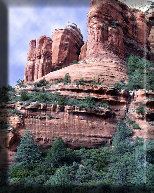
Providing a scenic setting for this unique habitat are a sampling of the picturesque buttes and cliffs for which the Sedona area is so famous. Steamboat Rock, Wilson Mountain, Maroon Mountain, and a number of unnamed cliffs, spires, windows and arches are visible from this trail. The trail ends at a red sandstone cliff where there are a few small Indian ruins and some primitive rock pictographs. Please don't disturb them.
See also Deadmans Pass Trail and Boynton Canyon Trail.
At a Glance
| Open Season: | Year-round |
|---|---|
| Usage: | Medium |
| Closest Towns: | Sedona, AZ |
| Operated By: | Red Rock District - 928-203-2900 |
General Information
General Notes:Rating: Easy
Hiking time: 3 hours
Notes:
- No motorized vehicles. No bikes
Click map thumbnail for larger view.

Directions:
Location: 2 miles west of Sedona, 32 miles south of Flagstaff, on paved roads. The elevation ranges from 4560 to 5000 feet.
GPS (Map): 34°54'24.0"N 111°49'27.5"W
Access: Drive 27 miles south from Flagstaff on US 89A through Sedona to Dry Creek Road. Turn north (right) about a mile and a half to Long Canyon Road (FR 152D) and north (right) again about 0.5 miles to the Long Canyon Trailhead on left.
Maps
- Red Rock Country Maps: Download Red Rock Country trail maps and find other Sedona recreation resources. See the Sedona Southeast [PDF] map for this trail system.
- Red Rock Recreation Guide [PDF]: Info on hiking, biking, camping, and more in Arizona's magnificent Red Rock Country. Download the guide or pick one up at the Red Rock Ranger District Visitor Center.
- The Digital Travel Map Whether you're driving, hiking, riding, or exploring, you will find this full-color, GPS-enabled map a handy reference to have on your mobile device. The map show trails, recreation sites, major landmarks, and forest roads.
- Forest Service Topo Map (FSTopo Geo-enable PDF)
Activities
Day Hiking
Horse Riding

Related Information
Location

