

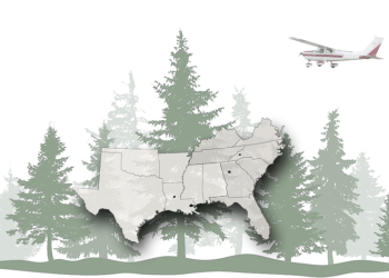
Forest Health
Forest Health Protection is a unit of the Department of Agriculture U.S. Forest Service that employs pest management specialists, forest entomologists, and plant pathologists to provide technical assistance in the prevention, detection, evaluation, and suppression of forest insect and disease pest problems. Forest Health Protection in the Southern Region serves Alabama, Arkansas, Florida, Georgia, Kentucky, Louisiana, Mississippi, North Carolina, Oklahoma, South Carolina, Tennessee, Texas, Virginia, and Federally-managed lands in Puerto Rico and the U.S. Virgin Islands.
Forest Health Protection
Who We Are
Forest Health Protection (FHP) traces its roots to the early 1960s. Plagued by serious insect and disease outbreaks, such as southern pine beetle, chestnut blight, spongy moth and fusiform rust, the Forest Service saw the need for a specialized unit designed to work exclusively on pest problems related to forest resource productivity and management.
The unit provides technical assistance in the prevention, detection, evaluation, and suppression of forest insect and disease pest problems. In addition, expertise is available in the areas of seed orchard pest management, nursery disease problems, pesticide use, protection of wood in use, and remote sensing for monitoring insect populations and/or damage.
FHP is comparable to other specialized Forest Service units, such as engineering, recreation, and wildlife. The most significant difference is that we provide forest health assistance not only to managers of National Forests, but to managers of all forested lands.
Where We Work
FHP maintains three offices in the Southern Region. Our headquarters are in Atlanta, Georgia and we have two field offices:
- Our office in Alexandria, Louisiana services the Western Gulf States: Texas, Oklahoma, Louisiana, Mississippi, Arkansas, and Alabama.
- The Asheville, North Carolina field office serves Virginia, North and South Carolina, Kentucky, Tennessee, Georgia, Florida, and federal lands of Puerto Rico and the U.S. Virgin Islands. FHP also administers the Resistance Screening Center near Asheville. There seedlings are screened for genetic resistance to destructive diseases.
Forest Health Programs
With the assistance of our state forestry cooperative partners, we annually survey forested areas of the South for forest health conditions. We conduct our surveys from aircraft to enable us to cover such a large area each year. Aerial surveying enables us to monitor forest health conditions more efficiently and economically than other methods. During the surveys, we look for areas with dying trees (from bark beetles, diseases, drought, other factors), various types of defoliation, and abiotic impacts such as from storms and weather patterns. The observer in the aircraft records the survey using a digital sketch mapping system (Digital Mobile Sketch Mapping ).
Region 8 Forest Health Monitoring Story Maps
Summary of spatial forest disturbance data across Region 8 compiled by the FHM Program, presented using the ESRI story map platform.
Survey Year:
Region 8 Forest Health Monitoring Dashboard
An interactive dashboard that allows visitors to query spatial forest disturbance data across Region 8 compiled by the FHM Program by year, damage type, state, etc.
https://www.arcgis.com/apps/dashboards/8441e73c5cef41dfb0285c993235f101
Annual Region 8 Forest Health Monitoring Survey Maps
- Regional Summaries
- Spongy Moth & Fall Cankerworm
2022 | 2023
Southern Pine Beetle Spots, 1998-2023 [PDF 11 MB]
Animated Progression (GIF)
Coastal Ghost Forest Mapping Project - Regions 8 and 9
Coastal ghost forests are areas of standing dead trees that used to be forest but because of sustained or permanent saltwater intrusion due to sea level rise, can no longer grow trees. Ghost forests often affect areas where ecosystem services are critical and ecosystem sensitivity and biodiversity are high. They can also be quite visible to the public due to being common in areas of high population density where tourism associated with coastal development is rampant.
The Forest Health Monitoring programs in regions 8 and 9 have partnered with various state cooperators and the USDA Climate Hub in order to document and highlight areas affected by coastal ghost forests. By using spatially explicit data on dead trees, the project intends to provide a baseline that can be used to assess and monitor the impacts of sea level rise on coastal forests going forward.
To help inform the public on this emerging issue, the project team has developed an ESRI story map and dashboard to provide the latest information and spatial data:
GIS Data
Please Note:
U.S. Forest Service, Forest Health Protection (FHP), along with our cooperators, strive to maintain an accurate Aerial Detection Survey (ADS) Dataset, but due to the conditions under which the data are collected, FHP and its partners shall not be held responsible for missing or inaccurate data. ADS are not intended to replace more specific information. An accuracy assessment has not been done for this dataset; however, ground checks are completed in accordance with local and national guidelines. Maps and data may be updated without notice. Please cite “USDA Forest Service, Forest Health Protection, Southern Region” as the source of this data in maps and publications.
Access ADS data by Forest Service Region from the National Program Page
SPB is the most damaging insect pest of pines in the Eastern U.S. During major outbreaks, the SPB severely impacts the region’s tourism and wood-based industries, and also negatively impacts watersheds and wildlife habitat, most notably that of the red-cockaded woodpecker. It is an aggressive tree-killing beetle which periodically damages extensive areas of pine forests from NY to FL to TX. From 1973-present SPB has caused almost $4 billion in economic damage. The worst recorded outbreak took place from 1999 – 2003 when SPB impacted more than a million acres in 7 states and caused more than $1 billion of damage, most on non-industrial, private land. Currently there is SPB activity in AL, FL, LA, MS, NC, SC and VA. The most significant activity is on the National Forests in MS (5,500 spots) and in Alabama.
Direct link to video: A Story About a Beetle
SPB Prevention Program
The SPB Prevention Program is a cornerstone piece to the Southern Region Forest Health Protection’s efforts to institute a comprehensive and integrated approach for preventing and reducing the impacts of SPB on federal, state, and private forests. The SPB Prevention Program was developed, at the request of Congress, after the last major outbreak in 1999-2003. The prevention strategy has been developed and implemented in close cooperation and integration with 12 National Forests and 13 Southern States. The million acres treated represents more than 13,000 landowners who have participated in cost-share programs and hundreds of loggers who have taken part in a logger incentive program. The logger incentive program is an innovative approach that was developed to help target smaller-acreage tracts and to save and restore jobs in the rural-based logging industry that has been struggling to survive the last several years. Since the SPB Prevention Program started in 2003, there has not been a major SPB outbreak, which has allowed for a single focus on prevention work instead of suppression activities. The SPB Prevention Program is a successful model upon which to develop future proactive forest health strategies that can be applied across large geographic areas and among many different cooperators and stakeholders.
The U.S. Forest Service has teamed up with ESRI to create an exciting new tool for the Southern Pine Beetle (SPB) Prevention Program. This web-based application is called a story map, which is designed for users to navigate through interactive maps accompanied by multimedia content and informative text.
- Direct link to video: Southern Pine Beetle Prevention Program
Region 8 Forest Health Monitoring 2023 Summary
A summary of spatial forest disturbance data across Region 8, compiled by the Forest Health Monitoring Program for survey year 2023, presented using an interactive ESRI story map.
Laurel Wilt Disease
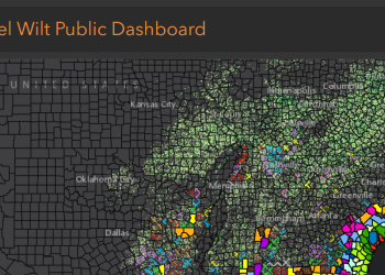
Learn more about Laurel Wilt and explore the updated regional infestation map for Laurel Wilt Disease.