
Henry M. Jackson Wilderness: Okanogan-Wenatchee
Senator Henry Jackson of Washington was instrumental in designating many of Washington's Wildernesses.
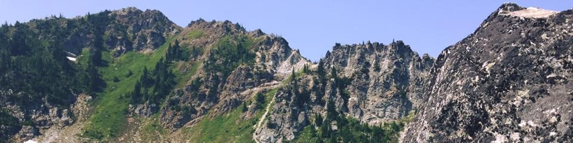
The 103,297-acre Henry M. Jackson Wilderness is located within both the Mt. Baker-Snoqualmie and the Okanogan-Wenatchee National Forests. Here you will find glacial basins surrounded by ragged ridgelines supporting sharp spires and rock towers. Snow often accumulates to a depth of 20 feet and remains well into summer. The melting snow feeds the multiple high mountain lakes in the northwest section. Tall forest at lower elevations thins out into broad meadows on ridge tops.
There are approximately 49 miles of hiking trails. Visitors can choose from easy day hikes to mountain lakes or hike the Pacific Crest National Scenic Trail through the Wilderness for about 32 miles. Henry M. Jackson Wilderness borders Glacier Peak Wilderness to the north and Wild Sky Wilderness to the southwest.
Help protect your wilderness by following wilderness regulations and using Leave No Trace principles.
Active Alerts
General Information
Some trailheads require a valid recreation pass. Check our Recreation Passes and Permits page for details.
- Some trails closed to use by stock due to steep grades, inadequate design, lack of grazing or other factors.
- Camping is prohibited within 200 feet, horizontal distance, from the shoreline of the following lakes: Goat Lake, Blanca Lake, Pear Lake.
- Using a fire or campfire, except for self-contained, carry-in devices such as stoves, is prohibited within 1/4 mile of the following locations: Goat Lake, Glacier Basin Trail, Silver Lake, Upper Twin Lake, Lower Twin Lake, Lake Sally Ann, Lake Minotaur, Lake Theseus, Heather Lake, Glasses Lake, Lake Valhalla.
Getting There
Directions
Henry M. Jackson Wilderness is near Stevens Pass, about 35 miles northwest of Leavenworth on US-2.
Trailheads that access Henry M. Jackson Wilderness:
- Smithbrook Trailhead - access to Smithbrook Trail #1590 and Pacific Crest Trail #2000.
- Heather Lake Trailhead - access to Heather Lake Trail #1526.
- Top Lake Trailhead - access to Top Lake Trail #1506.
- Little Wenatchee Ford Trailhead - access to Little Wenatchee Trail #1525, the Cady Creek Trail #1501, Pacific Crest Trail and Cady Ridge Trail #1532.
- Pacific Crest - Stevens Pass North Trailhead - access to Pacific Crest National Scenic Trail - Washington North Cascades.
- Lake Minotaur Trailhead - access to Lake Minotaur Route Trail #1517.
See also
Mt. Baker Snoqualmie National Forest - Henry M. Jackson Wilderness information.
Topo Maps
Bedal, Benchmark Mountain, Blanca Lake, Captain Point, Evergreen Mountain, Glacier Peak West, Labyrinth Mountain, Monte Cristo, Poe Mountain, Sloan Peak. Download free U.S. Forest Service Topo maps.
Buy maps online
Go to the National Forest Store.
Wilderness.net
Go to Wilderness.net for online maps and other important Wilderness information.
Facility and Amenity Information
Horse/Pack Animal Information
Horse/Pack animals are allowed at this site.
Weed-free feed is required. Find more information here.