
Coyote Wall Recreation Area

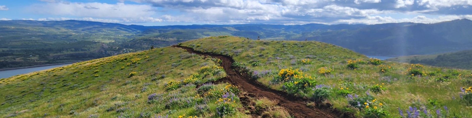
A massive formation of columnar basalt, Coyote Wall is one of the Columbia River Gorge's most recognizable features from all directions. Known around the Gorge as "The Syncline" - local amateur geologists enjoy debating its proper geological classification over a craft brew. From Coyote Wall Trailhead, bikers, hikers, and riders can access a 30+ mile network trails with an open feel and breath-taking views.

Mountain bikers love the range of mountain biking challenges which reward those who climb the trails with amazing panoramas of the Gorge! Naturalists can appreciate the diverse population of rare and sensitive plants found here. The thin, fragile soils were created by Missoula floods, and the habitat remains important for wildlife species.

General Information

Please avoid the area directly below Coyote Wall to the west, as it is private land. Trails in the area have been gradually rehabilitated in recent years according to a long-term site management plan, so user-created trails that once damaged natural resources are being decommissioned. New signs make it easy to stay on official trails but use maps with caution as most are now out of date. This planning map shows temporary names used during the planning process to label approved trails. Today's signs do not match the shorthand codes, but they do make it easy to stay on official trails.

Please respect signs indicating decommissioned trails and sensitive areas under restoration.

Area Restrictions:

  • Aircraft/UAS/drone takeoffs and landings are prohibited at this site.
  • Equestrian use prohibited seasonally from October 1 to April 30 in the Coyote Wall area, and not allowed at all on the nearby Catherine Creek Loop Trail.
  • Mountain bikes should stay on designated trails and respect recently decommissioned side trails or areas under rehabilitation.
  • Dogs must be on leash December 1 - June 30.
  • Raptor Trail (near Catherine Creek, known as Ca1 during the planning process) is closed from February 1 to June 15 to protect breeding raptors and other sensitive wildlife and plants.

Recreation Sites

Showing: 1 - 9 of 9 results

Bitterroot Trail (#4422)

This is a proposed two mile hiking/biking trail from the Catherine Creek Trailhead to Atwood Road, northeast of Coyote Wall.Currently, a user-created trail exists in this location, referred to as Ca2…

Coyote Wall Trail (#4428)

Biking Horse Riding and Camping Hiking
The trail was realigned away from the cliffs in accordance with the 2011 Catherine Creek, Coyote Wall, and Burdoin Mountain Recreation Plan. The new trail is designed for mountain bike use but open…

Coyote Wall Trailhead

Site Open
Biking Hiking Horse Riding and Camping
From Coyote Wall Trailhead, bikers, hikers, and riders can access a 30+ mile network trails with an open feel and breath-taking views. Please respect signs indicating decommissioned trails and…

Labyrinth Trail (#4423)

Biking Hiking Horse Riding and Camping
Runs through Coyote Wall Recreation Site, and connects to Desert Parsley, which continues on to the adjacent Catherine Creek Recreation Site.

Little Maui Trail (#4425)

Horse Riding and Camping Hiking Biking
This popular mountain biking trail in the Coyote Wall area rewards bikers with spectacular Gorge views.Please respect signs and closures as trail rehabilitation is ongoing here, with several side…

Little Moab Trail (#4425)

Biking Horse Riding and Camping Hiking
This popular hiking and mountain biking trail follows the top of the Coyote Wall geologic formation in the eastern Gorge and is easily reached from Coyote Wall Trailhead.This trail was previously…

Old Ranch Road Trail (#4426)

Hiking Horse Riding and Camping Biking
This trail follows an old Jeep road from Old Highway 8 before climbing the ridge of "Coyote Wall," an impressive rock wall known to locals as "The Syncline." It can be combined with Little Moab and…

Raptor Trail (#4421)

Biking Hiking
This short trail (less than half a mile) connects bikers and hikers from Desert Parsley Trail in the Coyote Wall area to Old Highway 8. It was formerly known as "Ca1" during the planning process and…

Upper Labyrinth (#4424)

Site Open
Horse Riding and Camping Biking Hiking
Located just south of Atwood Road in Klickitat County, Upper Labyrinth Trail connects to Desert Parsley Trail to the east, leading to the Catherine Creek Area. To the west, it links up with Labyrinth…

Last updated July 3rd, 2025