
Wilderness
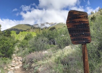
The Pike-San Isabel National Forests & Cimarron and Comanche National Grasslands is home to nine congressionally designated wilderness areas with over 385,000 acres of untrammeled opportunities for challenge, solitude, tranquility and personal growth. Wilderness areas provide critical habitat for a multitude of species and help to protect important natural resources, such as clean water.
Many of the forest's popular climbing peaks over 14,000 feet (fourteeners) are within designated wilderness areas. See the regulations below that apply for each wilderness (e.g., group size, number of stock animals, type of stock feed, campfires, camping locations and dogs) to minimize human impacts to these unique and special areas. Please always use Leave No Trace techniques to help keep these areas wild, clean and pristine!
Wilderness: Know Before You Go
Three wilderness areas—Holy Cross, Lost Creek and Mount Evans—require visitors to obtain self-issued permits that are available at each trailhead at no cost. Permits are required to measure the number of visitors using a wilderness area and educate visitors about the benefits of minimizing our collective impacts.
All commercial and nonprofit groups are required to obtain a special use permit through the local ranger district office in advance of their trip. If you are using the services of an outfitter-guide, be sure they are licensed and have a Forest Service permit.
Federal Regulations (36 CFR 261.18) for National Forest Wilderness
Motorized equipment and equipment used for mechanical transport is prohibited. This includes the use of motor vehicles, motorboats, motorized equipment, bicycles, hang gliders, wagons, game carts, portage wheels and the landing of aircraft, including helicopters.
Wilderness regulations on the Pike-San Isabel National Forests & Cimarron and Comanche National Grasslands
Group size
- Group size is limited to 15. Stock groups are limited to 25 with a maximum of 15 people.
Responsible pet ownership
- Pets must be under control at all times. Pets can harass, stress, injure or kill wildlife; introduce disease and disturb fellow hikers. Some wilderness areas require dogs to be leashed at all times.
Stock
- Secure animals 100 feet from lakes, streams and trails. A picket line is less damaging to trees than direct tying. Move stock often when picketing to prevent resource damage.
- Restraining or grazing of recreational livestock is not permitted within 100 feet of lakes or streams.
- Only certified weed-free hay or pelletized food is allowed.
Camping
- Campsites must be at least 100 feet from trails, lakes, streams and any water source. Please use an existing site when possible. Before leaving, "naturalize" your campsite by removing signs of your use.
- Obey posted signs prohibiting camping or other activities. Some campsites may be closed to allow the area to recover from overuse.
Trails
- Cutting switchbacks on trails is prohibited. Shortcuts cause severe erosion, eventually destroying the trail.
Peak climbers—cross country
- Delicate alpine tundra is very susceptible to damage. Walk on durable routes of rock or talus. In the spring, travel on snow and rocks, or plan your trip during drier conditions.
- Check with the local ranger district office on designated routes.
Waste
- Soap, even biodegradable, pollutes the water. Dispose of wash water at least 100 feet away from any water source.
- Bury human waste a minimum of 100 feet away from any water source, trail or campsite in a hole 6 to 8 inches deep.
- Pack out toilet paper, feminine products and leftover food. Otherwise, animals can dig it up. It is never acceptable to bury trash. Follow the rule: if you pack it in, then pack it out.
Campfires
- A lightweight backpacking stove is recommended. If a campfire is desired, build it in a manner that minimizes impact. Campfires should be at least 100 feet from lakes, streams and trails. Collect only dead and downed wood less than 3 inches in diameter. Remember: if you can't break it by hand, don't use it.
- Use existing fire rings. Avoid building fires above tree-line. Dead wood removed from Krummholz (dwarf trees near timberline) affects their survival.
- Do not build a fire on exposed rock surfaces to prevent scarring.
- If possible, use a fire blanket or a fire pan (like a pan used to change motor oil). Place several inches of soil in the bottom of the pan and build the fire on this. Always use extreme caution and avoid building fires in dry or windy conditions.
Water
All water can carry giardia—protozoa that affect the human intestinal system—and can cause serious illness. Water can be treated by boiling for five minutes, using iodine tables or filtering.
Fires
Campfires are a tradition, but please consider their impacts:
- Dead and downed wood is a component of the ecosystem.
- Concentrations of charcoal and ash sterilize soil, so consider using a fire pan.
- Many visitors consider fire rings an eyesore.
Food
Repackage food items to minimize plastic trash that you will need to pack out.
Always practice the seven Leave No Trace principles.
- Plan ahead and prepare
- Travel and camp on durable surfaces
- Dispose of waste properly
- Leave what you find
- Minimize campfire impacts
- Respect wildlife
- Be considerate of others
Buffalo Peaks Wilderness

Buffalo Peaks Wilderness, encompassing 41,232 acres, was congressionally designated in 1993. It get its name from the 13,000-foot Buffalo Peaks located 15 miles southwest of Fairplay, Colorado. Elevations range from 9,200 to 13,326 feet from sea level.
Collegiate Peaks Wilderness
Collegiate Peaks Wilderness was designated by the United States Congress in 1980, and it now has a total of 167,584 acres. Located in Colorado, this wilderness spans the Gunnison, White River and Pike-San Isabel national forests.
Greenhorn Mountain Wilderness
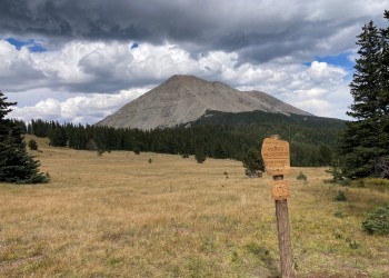
The Greenhorn Mountain Wilderness was designated by Congress in 1993, and it now has a total of 23,087 acres. Soaring dramatically from the plains of Colorado, Greenhorn Mountain rises from 7,600 to 12,347 feet in the center of the northern section. Its summit is the highest point in the wilderness, and nowhere else in the state provides such a vivid and dramatic change from plains to mountains.
Holy Cross Wilderness
Holy Cross Wilderness, established in 1980, now encompasses a total of 122,918 acres spanning San Isabel and White River National Forests. Its name comes from the 14,007-foot Mount of the Holy Cross, which dominates the northern end of the Sawatch Range, so named because of the 1,150-foot tall "cross" of snow facing northwest.
Lost Creek Wilderness

Lost Creek Wilderness was officially designated by the Colorado Wilderness Act of 1980 with additions in 1993. Today it totals 119,790 acres. Elevations range from 8,000 to 12,400 feet above sea level. Lost Creek was named after a creek of the same name that repeatedly disappears underground only to reappear again further downstream, where it ultimately becomes Goose Creek.
Mount Evans Wilderness

The United States Congress designated the Mount Evans Wilderness in 1980, and it now has a total of 74,401 acres. Mount Evans Wilderness is located approximately 40 miles west of Denver, Colorado. The Mount Evans Scenic Byway ascends a non-wilderness corridor into the center of the wilderness.
Mount Massive Wilderness
Mount Massive Wilderness was designated by Congress in 1980, and it now has a total of 30,540 acres. All of this wilderness is located in Colorado and is managed by the Fish and Wildlife Service and the Forest Service.
Sangre de Cristo Wilderness
Sangre de Cristo Wilderness was designated by Congress in 1993, and it now has a total of 220,803 acres. All of this wilderness is located in Colorado and is managed by the Forest Service and the National Park Service. The Sangre de Cristo Wilderness is bordered by the Great Sand Dunes Wilderness to the west.
Spanish Peaks Wilderness
The United States Congress designated the Spanish Peaks Wilderness in 2000, and it now has a total of 19,226 acres. Los Cumbres Espanolos, the Spanish Peaks, are prominent landmarks along the eastern front of the southern Rockies. Their snow-capped summits, rising 7000 feet above the arid plains, made the "Double Mountain" an easily recognizable reference point to travelers of all cultures.